Will Typhoon "Xuan Lannuo" land in my country?How does it affect the coastal areas?Expert analysis →
Author:Changjiang Daily Time:2022.09.03
Xuan Lannuo is less likely to land in my country
With the approaching of "Xuan Lannuo" to my country's coast, its impact on my country's storm is gradually prominent. According to expert analysis, judging from the current path of "Xuan Lannuo", it is less likely to land in my country.
It is expected that "Xuan Lannuo" will move north to west at a speed of about 15 kilometers per hour. It will move into the East China Sea today and gradually approach the coast of the northeast of Zhejiang.
Zhang Ling, chief forecaster of the Central Meteorological Observatory: Because of the considering the Western Wind Band System, and a changes in a subtropical high -pressure on the north side, there are some uncertain factors that have high pressure on the south side, which will lead to the Typhoon Center Center The distance from the coastline of our country may be reduced to a certain extent. We currently consider this possibility of landing, but we think that it is still not the same as logging in, and this possibility of turning offshore will be greater.

At present, the closest period of "Xuan Lannuo" and the nearest period of the coastal areas of East China will be from today to 5th, and the wind of Zhejiang coast will gradually increase. Meteorological experts remind that although Typhoon "Xuan Lannuo" is less likely to land in my country, the impact of wind and rain is still very strong. In the past, ships should return to the port to avoid wind and strengthen port facilities.
"Xuanlan Nuo" intensity may develop again
In the past day, Typhoon "Xuan Lannuo" stagnated in the east of Taiwan, and its strength was weakened from super typhoon to strong typhoon. But as "Xuan Lannuo" gradually approached the East China Sea, its intensity will develop again. So, why does "Xuan Lannuo" weaken before strengthening it? Zhang Ling, chief forecast at the Central Meteorological Observatory, analyzed ↓
After the development of yesterday, the wind -eye structure of Typhoon "Xuan Lannuo" is once again clear. It is expected that the future intensity will develop again. It may develop again into super typhoons again, and gradually approach to northeast Zhejiang.
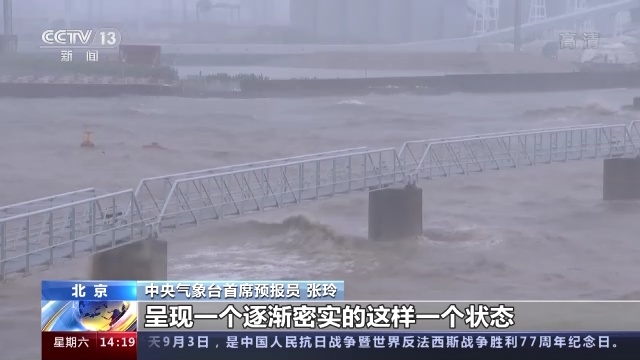
Zhang Ling, chief forecaster of the Central Meteorological Observatory: Yesterday, its intensity showed a state of attenuation, mainly due to the large vertical cutting, and some dry air was involved. level. Although the strength of Typhoon "Xuan Lannuo" has weakened, its entire framework structure is still very complete. As it gradually enters the East China Sea today, its structure will gradually appear in a tight state. Judging from the conditions of typhoon development, including the status of its sea temperature and the heat of the entire atmosphere, it is very conducive to the development of its intensity.
(Source: CCTV News Client)
【Edit: Zhang Jing】
For more exciting content, please download the "Da Wuhan" client in the major application markets.
- END -
Anti -drug delivery full of warmth full Mid -Autumn Festival
On the occasion of the Mid -Autumn Festival, on September 7, a member of the Drugs Social Workers in Wujiaxiang Center, Wujiaxiang Center, Wujiagang District, Yichang City, Hubei Province, and members
Today, 4 years ago, Donghu High -tech Zone released the "Outline of China Optics Valley 2035 Innovation Driven Development Strategic Action Outline" | Wuhan Calendar

Coordinating: Chen Zhi Design: Wang Yuzhe【Edit: Zheng Xiaoxiao】For more exciting...