"Xuanlan Nuo" moved into the East China Sea tonight, and Zhejiang Province's defense fingers increased the emergency response of typhoons to level II
Author:Published by Zhejiang Time:2022.09.03
According to the "Zhejiang Province Flood Control and Drought Resistance Emergency Plan", the provincial defense index was decided to increase the emergency response of typhoon prevention to level Ⅱ at 18:00 on September 3.
At 16:00 on September 3 on September 3, the Provincial Institute of Infinement adjusted the major meteorological disaster (typhoon) business service level III emergency response to a level II emergency response.
"Xuanlan Nuo" latest developments
At 18:00 today, Typhoon Xuanlan Nuo No. 11 this year is located at 24.1 degrees north latitude and 124.8 degrees east longitude. It is about 690 kilometers east of the south of Zhujiajian Island in Zhejiang Province.
It is expected to move north at a speed of 15-20 kilometers per hour, and the intensity will gradually increase. Today, I moved into the East China Sea in the middle of the night. The speed of the movement tomorrow has accelerated. It gradually moves towards the coast of the northeast of Zhejiang. On the 5th of the 5th, it will turn to the northeast in the northeast of Zhejiang.
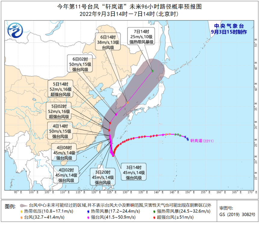
Affected by the periphery of "Xuan Lannuo", there have been heavy rain in Ningbo, Shaoxing, Jiaxing and other places since today. Among them, there are heavy rain in Ningbo. 8-9 high winds appeared on the coast of central Zhejiang.
According to the "Emergency Plan for Geological Disasters in Zhejiang Province", the Emergency Response Office of the Provincial Emergency and Prevention Conference of Geological Disasters has initiated the Grade IV emergency response at 9:00 on September 3. Relevant departments and regions should pay close attention to the development and changes of typhoons and weather risks of geological disasters, and do a good job of preventing and emergency work in the current geological disaster.
Zhejiang Natural Resources Department and the Provincial Meteorological Administration September 3:00 on September 3, jointly issued geological disasters Meteorological risk red warning
From 18:00 on September 3rd to 18:00 on September 4, Ningbo (Haishu District, Jiangbei District, Zhenhai District, Fenghua District, Yuyao City, Cixi City), Shaoxing City (Shangyu District) and other areas Gao (red warning); Ningbo (Beilun District, Lizhou District), Shaoxing City (Xinchang County, Lizhou City), Jinhua City (Pan'an County, Dongyang City), Taizhou City (Tiantai County) and other regions (Orange warning); Ningbo (Ninghai County), Shaoxing City (Yuecheng District, Keqiao District, Zhuji City), Taizhou (Xianju County) and other regions of geological disasters (yellow warning). Please pay close attention to the rainfall and do a good job of prevention of geological disasters!
Zhejiang Ocean Monitoring and Forecast Center released a red alert and storm trendy yellow alert based on the "Emergency Plan for the Marine Disaster"
Wave red alert
Affected by Typhoon No. 11 "Xuan Lannuo" (strong typhoon level), it is expected
近海海域:杭州湾有1.4米到2.2米的中浪,明天傍晚增大到2.5米到3.5米的大浪;浙江北部有3.5米到5.0米的大到巨浪,明天傍晚增大到6.0米到9.0 meters of mad waves to mad waves; there are giant to mad waves from 4.0 meters to 6.0 meters in central Zhejiang, and will increase from 7.0 meters to 10.0 meters to mad waves tomorrow evening. The waves will increase from 9.0 meters to 12.0 meters tomorrow evening. The warning level of the sea waves in the sea is orange.
Near -shore waters: Jiaxing has 1.4 meters to 2.2 meters in the middle wave, and tomorrow evening will increase to large waves from 2.5 meters to 3.5 meters; Zhoushan has a large wave from 2.5 meters to 3.5 meters. The waves; Ningbo has a large wave from 2.5 meters to 3.5 meters, and will increase to a giant to the wild wave from 4.0 meters to 6.0 meters tomorrow evening; Taizhou and Wenzhou will be from 3.0 meters to 4.0 meters from large to huge waves. To 6.0 meters of giant to mad waves. Near -shore sea wave warning levels are red.
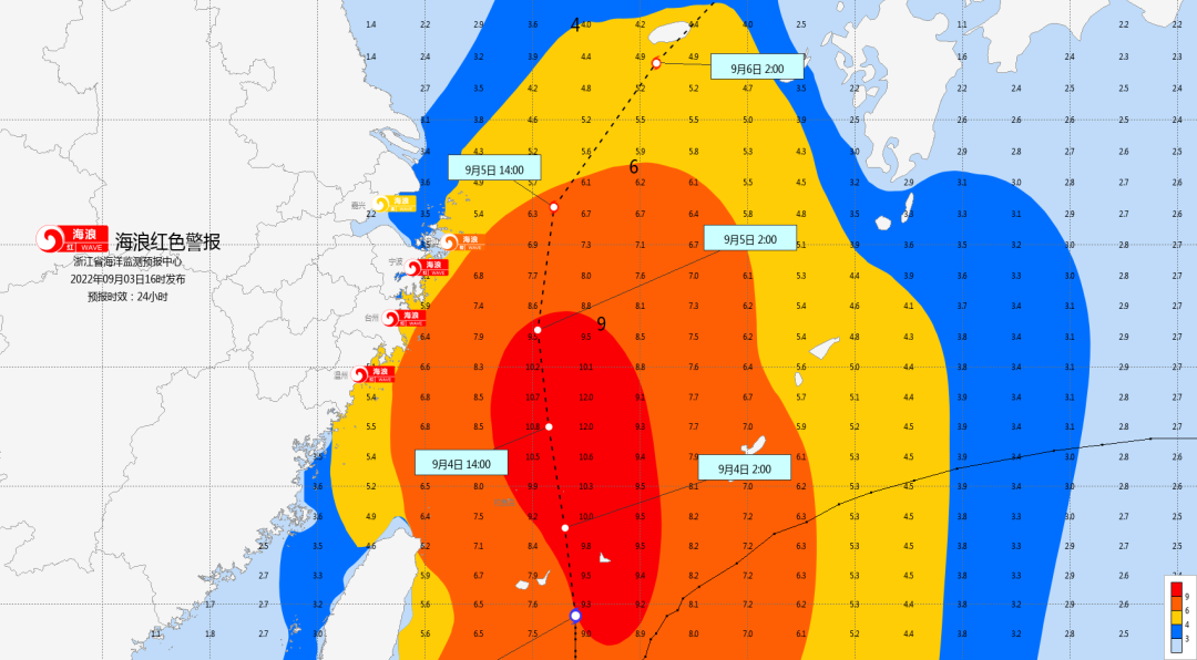
Wave Police News
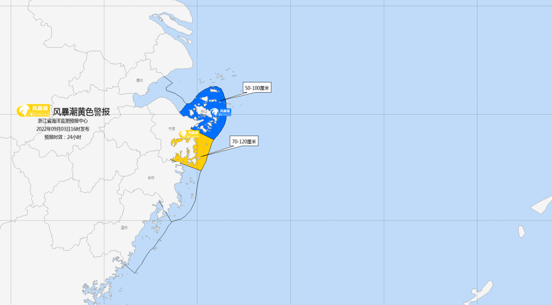
Storm Tide Yellow Alert
Affected by Typhoon No. 11 "Xuan Lannuo" (strong typhoon level), it is expected
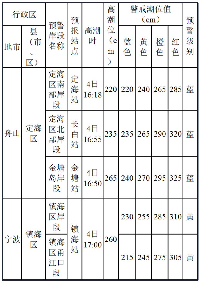
A 50-100 cm storm will increase water along the Zhoushan coast, and 70-120 cm of storms will occur along the coast of Ningbo. Zhenhai Station will have orgasm that exceeds the local yellow warning tide; Dinghai, Changbai, and Jintang Station will appear more than the orgasm of the local blue warning tide. The storm wave warning level is yellow.
Storm wave alert map
Zhejiang improves the emergency response level of typhoons in many places
Ningbo City
According to the "Ningbo City Flood Control and Drought Resistance Emergency Plan", Ningbo's defense index was decided to increase the typhoon prevention response to level II on September 3.
Wenzhou city
According to the "Wenzhou Flood Control Station Drought Resistance Emergency Plan", Wenzhou's defense index decided to increase the response to typhoon prevention to level II from 15:00 on September 3.
Taizhou
According to the "Taizhou City Flood Control and Drought Resistance Emergency Plan", Taizhou's defense index decided to increase the emergency response to typhoon prevention to level Ⅱ at 16:00 on September 3.
Warning
Affected by the strong typhoon "Xuan Lannuo", on September 3, there were local heavy rainstorms in the east of the northern part of Zhejiang, among which there were heavy rain in Ningbo and Zhoushan area. 4-5 on the eastern part of Zhejiang, there are mid-to-heavy rain. Among them, there are heavy rains in Ningbo, Zhoushan, Jiaxing, Shaoxing, Taizhou, East Jinhua and other places, and local heavy rain. There are more than 300 mm or more mountainous areas such as Siming Mountain.
Each city, especially Ningbo, Jiaxing, Shaoxing, Jinhua, Zhoushan, and Taizhou City, they should pay close attention to the development of the typhoon "Xuan Lannuo" and the development of the rain.Should be "all kinds of responsible persons.It is necessary to strengthen publicity notifications, rolling the typhoon dynamics, guiding the masses to strengthen the awareness of typhoons, and reasonably arrange travel plans.It is necessary to strengthen emergency duty, strictly implement the leadership class, 24 -hour duty system, and in accordance with the "six questions" random inspection mechanisms, strengthen the random inspection of the person responsible for flood control and personnel on duty, strictly implement the regulations for the reporting of disaster information. Once a sudden occurred, a sudden occursSend an incident to achieve the Morning Post and Express.The content is based on the Central Meteorological Observatory, Zhejiang Weather, Zhejiang Emergency Management, Zhejiang Ocean Monitoring and Forecast Center, Wenzhou Release, Taizhou Release, Ningbo Release, etc.
"Xuanlan Nuo" may be enhanced to super typhoons. There are strong precipitation in these areas.
Xue Editor: Ji Qunya
Editor in charge: Ding osmanthus
- END -
Urumqi City released 30 measures to help companies relieve rescue
Pomegranate/Xinjiang Daily (Reporter Guo Qian reported) On August 26, the Press Office of the People's Government of the Autonomous Region held a press conference on epidemic prevention and control. A...
Shaoyang held the first Hunan-ASEAN trading party management and control deployment work meeting
(Reporter Li Chengjun Correspondent Zeng Shaoshi Qiu Zhijun) On the afternoon of August 19th, the Shaoyang Market Supervision and Administration Bureau held the first Hunan-ASEAN Investment Trade Fair