Shenzhen has continued to dry up 3 days from this day, high temperature 34 ℃+does it have a "autumn feeling"?
Author:Crystal report Time:2022.09.04
In Shenzhen in September, the sky is refreshing, the cool wind is learned, and the "blessing" of the Beibei wind, "as if there is an illusion of autumn."
In terms of seasonal division standards, Shenzhen has not reached the autumn standard, so where does this faint autumn coming from? According to reports, the weak cold air guided by "Xuan Lannuo" stirred a burst of northern wind.

The temperature in the afternoon yesterday (3rd) was generally above 30 ° C, and the highest temperature was 34.1 ° C. It appeared in Meisha Street, Yantian District. At the same time, relative humidity is generally 40-60%, which is relatively dry.

Early in the morning, the sun was brilliant. Did you be cured by the sky?

The weather in Shenzhen reminds that it will continue to be dry on sunny days from this day.

The weather today: dry day, hot at noon; temperature of 26-33 ° C; north wind 3-4 levels, gusts at the coast, highlands and sea areas 6-7; relative humidity 45%-80%.

Weather trend: September 5-6 is sunny and hot, and the weather is hot. On the afternoon of the 6th, there are occasional (thunder) showers; 7-9 days of clouds increased, there are showers or thunderstorms, and the hot weather is relieved.
At present, the city's high -temperature yellow warning is effective.
"Xuanlan Nuo" will once again enhance the strong typhoon -level Zhejiang and Shanghai and other places.
Overnight, because the subtropical high pressure has been disconnected, the typhoon "Xuan Lannuo" began to the north under the guidance of the auxiliary high on the east side. Its north cloud system is much plump than before, and finally bid farewell to the "bald" state.

The Central Meteorological Observatory continued to issue a yellow warning of typhoon this morning. At 8 am this morning, the center of "Xuan Lannuo" (strong typhoon) is located on the sea about 470 kilometers east of the south of Zhujiajian Island, Zhejiang Province. It is expected that it will move north to the west at a speed of 20 kilometers per hour, and the intensity will gradually strengthen. Today, it will be strengthened to a super typhoon grade (level 16, 52 ~ 55 meters per second) during the day. Essence From the night of the 4th to the morning of the 5th, it will move around the northeast near the sea surface of Zhejiang. The last time is about 150 to 170 kilometers from the Zhejiang Coastline, and then gradually moves towards the southern part of the Korean Peninsula to the Korean Strait. The next 36 hours will be the main impact period of "Xuan Lannuo" on my country's land and offshore.

In terms of temperature, in the next few days, due to the influence of sinking air flow and sunny radiation in the periphery of "Xuan Lannuo", the southern autumn tiger is brewing to return. High temperatures mainly appear in South China. The high temperature range will be significantly expanded north next Monday, but the main is that the highest temperature rises significantly, and the relative humidity is not very high. Dry heat will be mainly during the day.
Source | Jingbao APP
- END -
Taiyuan will build a new bridge here.
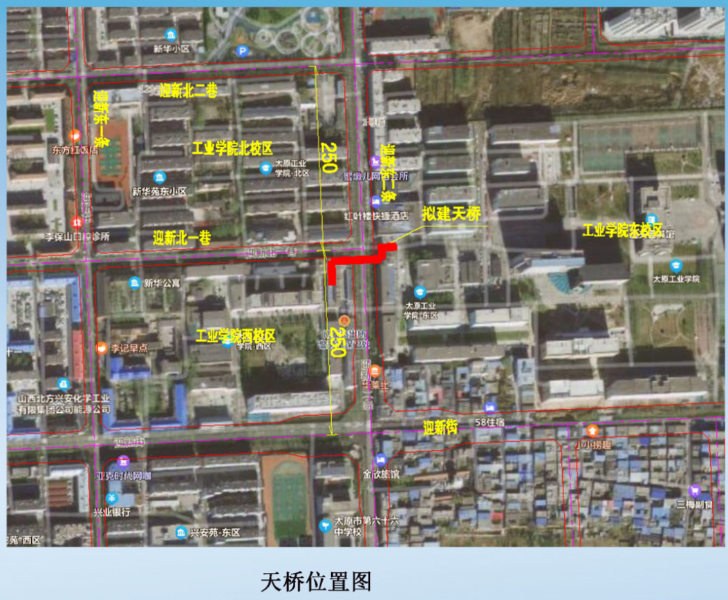
1. Bridge plan:Taiyuan Institute of Industry is located north of Yingxin Street, w...
[Patrol · Meishan chapter] Chen Yunhua, director of Qingshen County Zhilian Federation: Use craftsmanship to enable rural revitalization to add color

In series of resources, the craftsmanship is made into a heritage. Mr. Chen Yunhua...