Just released by Hangzhou: Upgrade!The crazy waves of the offshore are coming, Zhejiang released a red alert, storm trendy yellow alert
Author:Voice of Zhejiang Time:2022.09.04
Source: Sound of Zhejiang Comprehensive Hangzhou Defense Independence Office, reporter Wu Di
The copyright belongs to the original author, if there is any infringement, please contact it in time
Typhoon No. 11 this year "Xuan Lannuo" (strong typhoon) is located on the south of the East China Sea about 631 kilometers from the south of Hangzhou at 8 o'clock today. The radius radius is 300-400 kilometers. According to the "Hangzhou Flood Prevention and Drought Resistance Emergency Plan", the city's defense index was decided to increase the emergency response of typhoon prevention to level III at 9:00 on September 4.
Typhoon latest dynamics
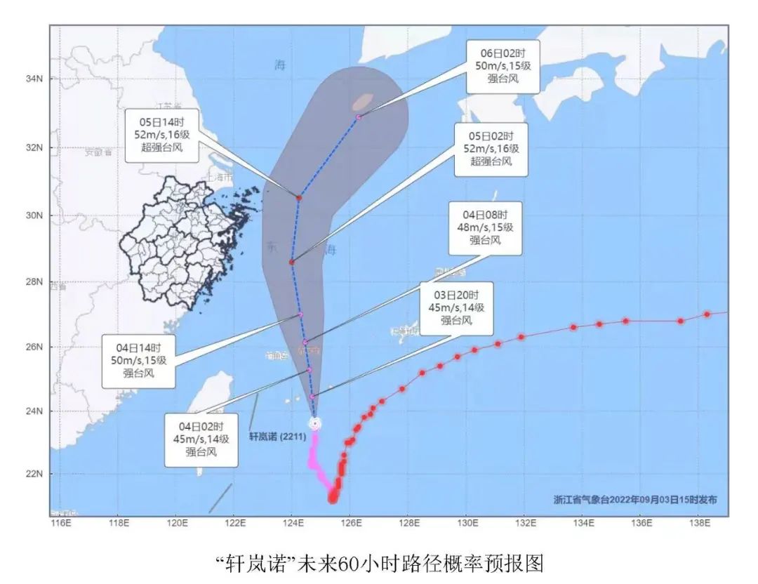
According to the Central Meteorological Observatory, Typhoon Xuan Lannuo (Strong Typhoon Grade) this year is located on the south of the East China Sea about 631 kilometers from Hangzhou south at 8 o'clock today. ), The seven-level wind ring radius is 300-400 kilometers. It is expected that "Xuan Lannuo" will move north at a speed of about 15 kilometers per hour, and the intensity will be slowly enhanced. The maximum possibility of the typhoon center will go north of 123-125 degrees east longitude, and move to the northeast after the morning of the 5th.
Affected by the circulation of the "Xuanlan Nuo" typhoon, at 2:00 on the 4th, there was a shower in the province. There were 10-30 mm precipitation in the eastern part of Hangzhou. The rainfall of the county (city, district) is: 6.0 mm in Gongshu District and 5.5 mm in Xiaoshan District.
Wind and rain forecast: Today, Qiantang, Xiaoshan, Fuyang, main urban areas, and parts of the mountainous areas in the northwestern region of Lin'an and Yuhang have local heavy rains. This day, there are 6-9 levels of high mountainous areas and Qiantang Rivers and other rivers and lakes. Level 10 individual level 11 wind.

Typhoon anti -typhoon in Hangzhou
Copy public defense guidance
Click to check

The crazy waves of the offshore are coming
Zhejiang released a red alert, storm trendy yellow alert
At 10 o'clock on September 4, the Zhejiang Provincial Marine Monitoring and Forecast Center issued a red warning and a yellow alert for storms based on the "Emergency Plan for Marine Disaster".
Affected by Typhoon No. 11 "Xuan Lannuo" (strong typhoon level), it is expected to be noon today to noon tomorrow:
(1) The sea area: Hangzhou Bay is from 2.0 meters to 3.0 meters in the middle to large waves, and it will increase to large waves from 3.0 meters to 4.0 meters at night; 8.0 meters to 10.0 meters of mad waves to madness; central Zhejiang and southern parts of 8.0 meters to 10.0 meters of mad waves to mad waves, and the sea surface passed by the typhoon center will appear more than 12 meters. The warning level of the sea waves in the sea is orange. (2) Near -shore waters: Jiaxing is from 1.6 meters to 2.5 meters in the middle to large waves, and it increases to large waves from 2.5 meters to 3.5 meters at night; Zhoushan and Ningbo have 3.5 meters to 5.0 meters of large waves, which will increase at night to the night to increase to the night to increase to the end of There are giant to mad waves from 4.0 meters to 6.0 meters; Taizhou and Wenzhou have 4.0 meters to 6.0 meters of giant to mad waves. Near -shore sea wave warning levels are red.
Affected by Typhoon No. 11 "Xuan Lannuo" (strong typhoon level), it is expected to be noon today to noon tomorrow:
A 50-100 cm storm will increase water along the Zhoushan coast, and 70-120 cm of storms will occur along the coast of Ningbo. Ningbo storm warning level is yellow; Zhoushan storm trendy warning level is blue.
- END -
Shenzhou: In -depth promotion of high -standard farmland construction makes the fields more vibrant

Dongguang, Hebei: Drama enters the rural culture to benefit Wanjia

In order to vigorously promote the excellent traditional culture of China and enri...