alert!Super Typhoon "Xuan Lannuo" strikes
Author:Upstream news Time:2022.09.04

Source Xinhuanet editor Cai Haiyan

not
At around 11 am on September 4th, Typhoon Xuan Lannuo, No. 11 this year, strengthened its level to super typhoon. As it approached step by step, my country has entered the main time period of Typhoon "Xuan Lannuo". Although "Xuan Lannuo" does not land in my country, its circulation is huge, and it will be combined with cold air. The wind and rain are widely affected. East China and even the Northeast will be affected.

It is expected that "Xuanlan Nuo" will move north at a speed of 15-20 kilometers per hour, and the intensity will be enhanced. It will gradually approach the sea in northeast Zhejiang. It started to move to the northeast morning in the morning and tended to the southern Korean Peninsula to the area of the Korean Strait.
Affected by "Xuan Lannuo", there will be strong wind and rain along the coast of East my country, and there will be heavy rain in the northeast of Zhejiang. In addition, the number of cold air in North China, Northeast and other places in the north will also increase.
1 "Xuan Lannuo" is strengthened again to be a super typhoon again
The Central Meteorological Observatory continued to issue a yellow warning of typhoon at 10:00 on September 4:
Typhoon No. 11 this year's "Xuan Lannuo" (strong typhoon level) center on September 4th is located on the south of the East China Sea in the south of the south of the south of Zhujiajian Island, Zhejiang Province, which is 26.2 degrees north latitude and east. 124.5 degrees, the maximum wind near the center is 15 levels (48 meters/s), the lowest air pressure in the center is 945 hundred Pache, the seventh-level wind ring radius is 300-400 kilometers, the 10-level wind ring radius is 100-150 kilometers. Railway 30 kilometers.
It is expected that "Xuan Lannuo" will move north at a speed of about 20 kilometers per hour, and the intensity will gradually be strengthened. The northeast is close to the sea. From the 4th to the morning of the 5th, it will be on the north of Zhejiang's offshore. On the morning of the 5th, it will move to the northeast.
Great Wind Forecast:
From 14:00 on September 4th to 14:00, the bus strait, Taiwan Strait, Taiwan's east, most of the Yellow Sea, East China Sea, Yangtze River Estuary District, Hangzhou Bay, Taiwan Island and its coast, central and northeast coast of Fujian, northeast Zhejiang, northeast Zhejiang , Shanghai, Jiangsu and the coast, and the coast of the Shandong Peninsula will have 6-9 strong winds, and the gusts are 10-11. Among them, the wind on the sea of the East China Sea, the sea of Hangzhou Bay, and the northeast of Zhejiang have 10-12 levels. At the 11-13 level, the wind on the sea across the "Xuan Lannuo" center is 13-16, and the gusts can reach level 17 and above.
Precipitation forecast:
From 14:00 on September 4th to 14:00, there were heavy rain in northeast Zhejiang, Shanghai and northern Taiwan Island. Among them, there were heavy rains (100-150 mm) in northeast Zhejiang and coastal areas.
Defense guide:
1. Government and relevant departments do a good job of preventing typhoon rescue emergency in accordance with their duties.
2. Related water operations and past ships should return to the port to avoid wind, strengthen port facilities, and prevent the ship's anchor, stranding and collision.
3. Stop outdoor dangerous operations such as large -scale rally indoor and outdoor and high altitude.
2 State Defense
Improve the emergency response to flood prevention and typhoon to the third level
The reporter learned from the Emergency Management Department on the 3rd that, given that the typhoon "Xuan Lannuo" No. 11 this year will seriously affect my country, the state defense promoted the emergency response of flood prevention and typhoon to the third level on the day of the state defense. deploy.
The National Defense Office and Emergency Management Department emphasized that the typhoon "Xuan Lannuo" has the characteristics of complex and changeable paths, strengthening strengths, and extensive influences. Responsible and flood prevention and typhoons at all levels, and organize the responsible system of flood prevention and fascination. The responsible persons of the flood prevention and typhoon at all levels will conduct in -depth supervision and inspection, strengthen the research and judgment of the federation of the federation of the federation of the federations such as meteorological and natural resources, closely monitor the development and changes of the wind, and release early warning information in a timely manner It
It is necessary to implement the various work of typhoons at sea in accordance with the settlement of the accounts, increase the implementation of the work of ships to return to Hong Kong to avoid wind, and the work staff evacuated ashore.
We must conduct in -depth investigation of hidden dangers of land risk, pay special attention to objects that are easy to fall and fall, and take measures such as reinforcement, protection, alert, and other measures to do a good job of prevention and response of disasters such as flood geological disasters, small and medium rivers, and urban and rural waterlogging. Tourist scenic spots, seaside baths and other places, organize evacuation tourists, and take control measures;
It is necessary to resolutely do a good job of transfer of personnel transfer, earnestly understand the number of threatened people in the dangerous areas, in particular to strengthen mobile personnel such as foreign business, migrant workers, tourists, etc., and further refine the transfer of risk aversion measures;
It is necessary to strengthen the reporting of major dangerous situations and disaster conditions to ensure that the report is timely and accurate.
At present, the two working groups of the National Defense Office have assisted in guidance and guidance of flood prevention and typhoon in Zhejiang and Jiangsu provinces.
3 The Ministry of Transportation Starts
Defense Typhoon No. 11 "Xuan Lannuo" level III response
On the 3rd, the reporter learned from the Ministry of Transport that according to Typhoon Xuanlan Nuo No. 11 this year, the Ministry of Transport will increase the defense of the Typhoon Class IV response to level III at 17:00 on the same day.
According to reports, the Ministry of Transport requires timely organizing maritime operators to evacuate risks, highlight key waters, key ships, organize maritime ship scientific selection of wind -free waters to prevent accidents from taking an anchor, stranding, collision and other accidents;Flood prevention and wind control measures under construction, strengthen the investigation of hidden risks, timely organize personnel to transfer risks, strengthen the operation monitoring and travel guidance of road network operations, and conduct timely development of the traffic;
Highlight the fields of flood prevention and typhoon prevention and typhoon prevention and typhoon prevention and typhoon prevention and typhoon prevention and typhoon prevention and typhoon prevention and typhoon prevention and typhoon preventing typhoons strictly suspended in accordance with relevant regulations.
Strictly implement the system of leading classes and 24 -hour duty, strengthen dispatching guidance, and conduct emergency response in a timely manner.
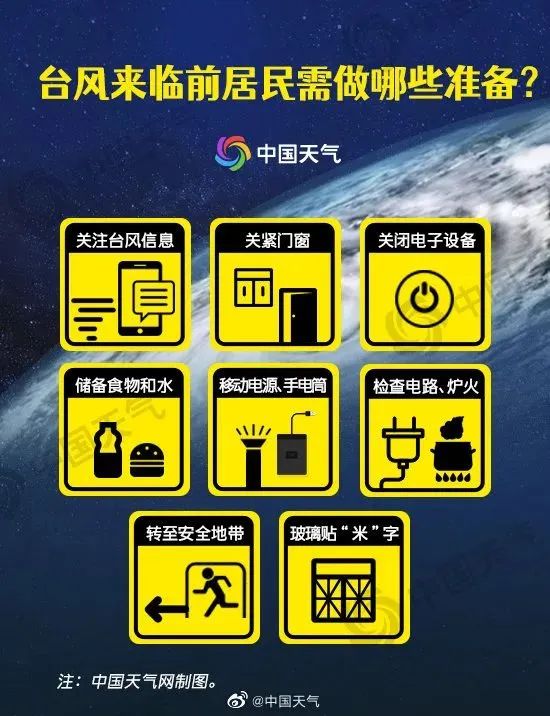
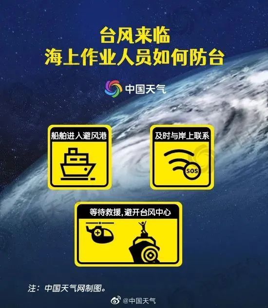
4 Typhoon strikes
How should we prevent?
Typhoon is here, what should we do?Poke the picture below to understand


- END -
Crowded and cool, look forward to you!1,000 copies of cooling bags are sent to the front -line sanitation workers
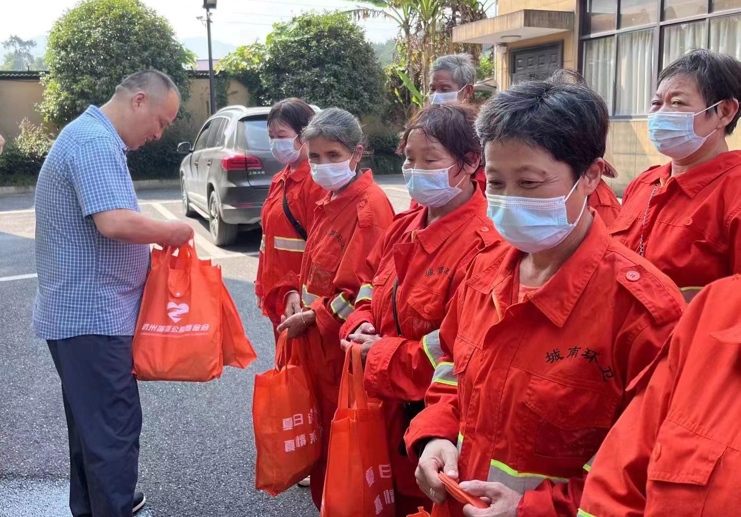
You are the Beauty Artist 'of this city. Everyone paid for the beauty and cleanlin...
Cultural tourism integration promotes the development of the whole region to improve
As a well -known provincial tourist resort, Tai Baihu New Area is known as a bright pearl on the southwestern land of Ru. In recent years, Tai Baihu New District has continuously accelerated the const