The super typhoon "Xuan Lannuo" is coming!Rizhao issued the latest notice!
Author:Rizhao News Network Time:2022.09.04

The sky is high, colorful
The sense of atmosphere of the sunshine autumn
Suddenly it was filled with the quiet beauty

Shan Ying/Photo
Not just the scenery
Recently, the temperature of the hot and hot when sunshine is hot
Also remind us of the arrival of autumn
Rizhao City Meteorological Bureau
At 17:30 on September 04
Meteorological Service Express
Typhoon No. 11 "Xuan Lannuo" trend analysis
The center of Typhoon No. 11 this year "Xuan Lannuo" (Super Typhoon Level) is about 340 kilometers southeast of the southeast of Zhujiajian Island, Zhejiang Province today (September 4) at 17 pm. 52 meters/s), the lowest pressure in the center is 935 hundred Pache.
It is expected that "Xuan Lannuo" will move north at a speed of about 15 kilometers per hour. The intensity is maintained or enhanced. It will gradually approach the sea in northeast Zhejiang. On the north, it began to move northeast in the afternoon of the 5th, tending to the southern Korean Peninsula to the area of the Korean Strait. (see picture 1)
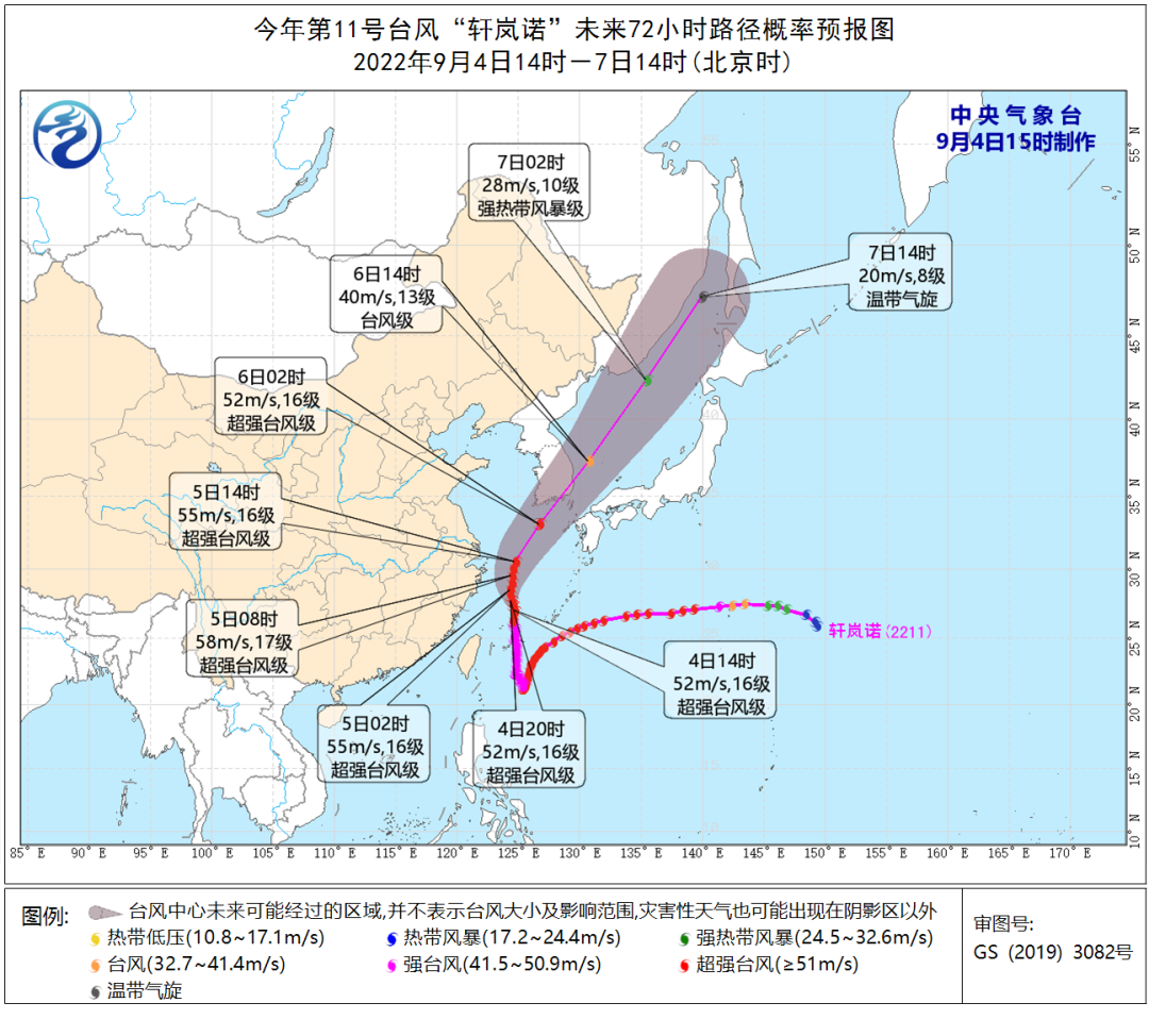
Figure 1 Typhoon "Xuan Lannuo" future path probability forecast chart
According to the current data analysis, "Xuan Lannuo" has a small impact on the land of our city. On the 4th, the north wind is 4 to the 4th, level 6 to 7, and level 8 of gusts; , Gust 7th level, the sea is enhanced to level 7 and gusts 8-9.
Because "Xuan Lannuo" is far from our city, the influencing factors are complicated, and its later movement paths have certain uncertainty. The meteorological department will closely monitor the weather changes and strengthen the tracking and judgment.

September 4
Notice of the Office of the General Headquarters of Rizhao Flood Control and Drought Resistance
Further do a good job of Typhoon No. 11 "Xuan Lannuo"
Defense work
Typhoon No. 11 this year, "Xuan Lannuo", has a large intensity and a wide range of influences. Over time, the impact on our city will gradually increase. According to the current data analysis, "Xuan Lannuo" has a mainly influence on our city on the sea. On the 4th day, the north wind is 4 to the 4th level, level 6 to 7, and level 8 of gusts; , Gust 7th level, the sea is enhanced to level 7 and gusts 8-9. Relevant departments at all levels are requested to further strengthen monitoring and forecasts in accordance with the requirements of provincial and municipal defense notifications, and more strict and more accurate monitoring of typhoon path changes. Fine detailed investigation of key hidden dangers such as high -altitude structures, easy to fall, and coastal areas to eliminate risks in advance to eliminate risks in advance Hidden dangers; further strengthen the release of early warning information, send the typhoon warning information to the responsible person of each operating ship and shipbuilding insurance, remind science and effective avoidance of wind and risk, ensure that the early warning information is available to the ship, the full coverage, and no omissions; further strengthen the right right right. Maritime operating fishing vessels, transport ships, only maritime operating vessels, merchant ships and other management. The management section takes the measures of suspension, shutdown, and production suspension. All fishing vessels (including fishery operating vessels only) must be returned to Hong Kong or choose the Hong Kong to avoid the wind in the near future to ensure that the ship enters the port, and the ship enters the port. People go ashore. It is necessary to strengthen the safety supervision of the centralized mooring points of fishing ports and fishing vessels, strengthen fishing ports, docks and other facilities, and properly arrange fishing vessels to mock spacing; strengthen maritime transportation organizations, increase the anchor distance between coastal anchor ships, strictly prevent the anchor, ensure that there are no problems with problems. Essence
According to the Municipal Meteorological Bureau
Based on the current data analysis
"Xuanlan Nuo" has a small impact on the land of our city
What about the specific situation
Pay attention to the weather next week, right?

According to the Municipal Meteorological Bureau, it is expected that the weather in our city will be based on the cloud system next week. On Monday, due to the peripheral of Typhoon Xuanlan Nuo No. 11 this year, the wind north of the sea can reach 7 and gusts 8-9 levels. There are weak precipitation on Sunday. The temperature is suitable.
The urban area is predicted as follows:
Monday (September 5): Cloudy and sunny, fog or light fog, northwind is enhanced to level 4, 20-28 ° C;
Tuesday (September 6): Sunny to Shaoyun, northwind to 4-5 to the southwest wind 3 to 4, 18-28 ° C;
Wednesday (September 7): Sunny turns cloudy, west wind turns east wind 3 to 4, 18-28 ° C;
Thursday (September 8): Cloudy, northern wind turning southwind, 3 to 4, 19-27 ° C;
Friday (September 9): Cloudy, 3rd winds in the south, 19-25 ° C;
Saturday (September 10): Cloudy turns overcast, southwind 3, 19-25 ° C;
Sunday (September 11): Cloudy turns overcast, there are light rain in some areas, 3 to southwest wind level, 19-25 ° C.
Please pay attention to the forecast early warning in time
Pay attention to weather changes
Beware of a cold
All media reporter Rong Xinxin
The "Rizhao Daily Video" is new!
- END -
Protection Provincial Games

The picture shows the on -site patrol of Leshan Public Security Police at the open...
Pan Shitao's Political and Legal Pioneer Team to send watermelon grain and oil, fertilizer, and help girls go home

The newspaper (Li Pengcheng Xu Fei) Send watermelon grain and oil to left -behind ...