Stop class again!Today Zhejiang's local heavy rainstorm, Hangzhou traffic police important reminder
Author:Global Times Time:2022.09.05
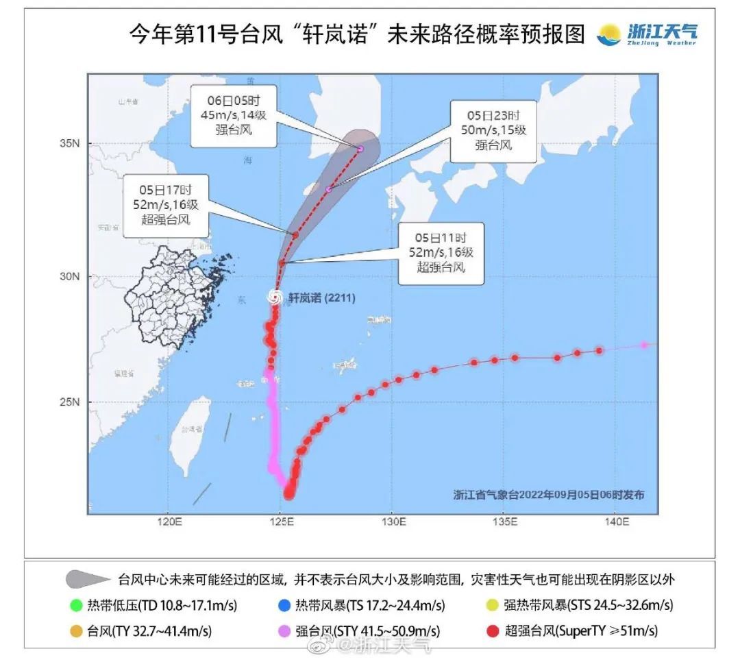
6 o'clock this morning,
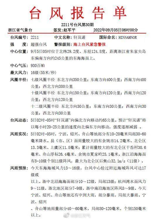
Typhoon "Xuanlan Nuo" is from the south of the east part of Zhujiajian Island
About 250 kilometers on the East China Sea surface
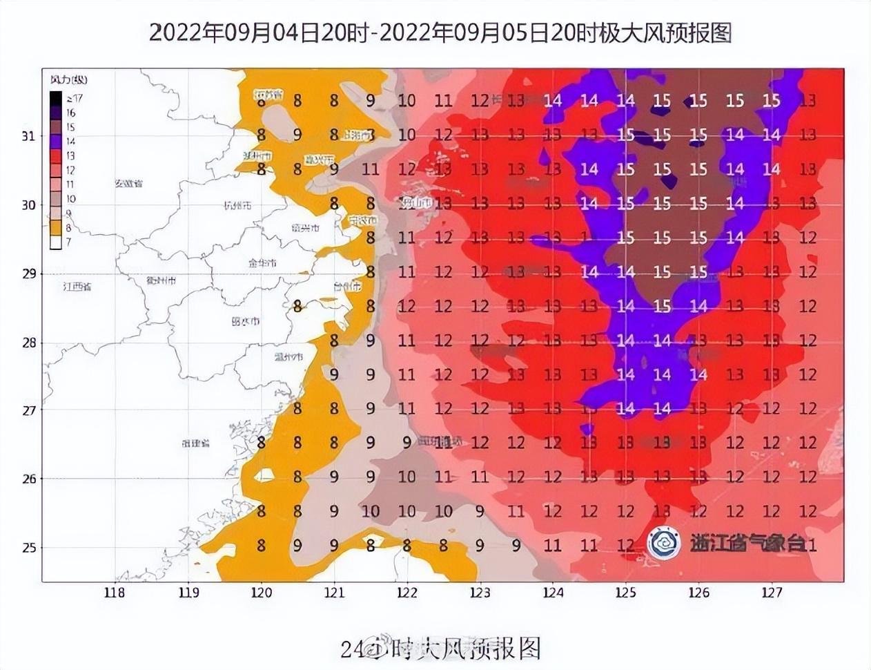
The maximum wind is 16 levels
As "Xuan Lannuo" approached step by step,
It is gradually prominent on the impact of my country's storm.
"Xuan Lannuo" is very powerful, and the storm strikes.
At 7 am on September 5th,
The official Weibo of Zhejiang Weather released the latest typhoon report display.
Today, Ningbo, Shaoxing, Zhoushan and other places still have middle to heavy rain.
Some heavy rain, local heavy rain.
Today early morning
Many people are awakened by huge wind sounds
More people have an analogy:

This wind sounds more than alarm clock
In the afternoon of September 4, affected by the super typhoon "Xuan Lannuo"
The coast of Wenling Shitang set off a huge wave of over 10 meters
Police 24 hours stick to the front line
The coastal patrols are persuaded to return to Guanlang
yesterday afternoon
Shengsi coast set off a wave of stunning waves
Zhejiang another place to stop class today for a day
Affected by the super typhoon "Xuan Lannuo"
September 5th (Monday)
Taizhou City
Each primary and secondary schools, kindergartens, and off -campus training institutions
Stop class for 1 day
Previously,
Wenzhou, Zhoushan, and Ningbo have released the news of today's suspension of classes
Zhejiang Meteorological Bureau
Start major weather disaster (typhoon) business services
Level I response
At 21:00 on September 4th, the Zhejiang Meteorological Bureau adjusted the major meteorological disaster (typhoon) business service level Ⅱ emergency response to class Ⅰ. Research, maintain or adjust to the corresponding response state.
Ningbo launched a sea -level emergency response to Taiwan
Ningbo's defense finger decided to launch a sea -level emergency response at 21:00 on September 4.
"Xuanlan Nuo" to the morning
Close to Zhejiang
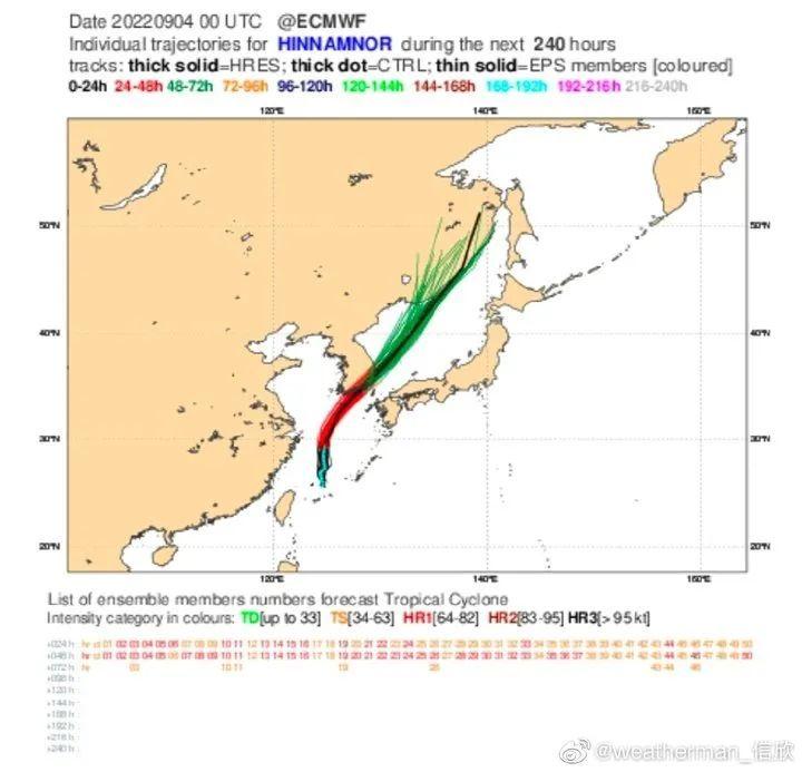
According to Xinxin analysis of the meteorological channel meteorological channel meteorological channel, from the cloud map of the evening yesterday, the high -pressure Qingkong area is not obviously westward, so Xuan Lannuo will not land in my country. The path has been greatly converged. Judging from the forecast path of the Central Meteorological Observatory, on the morning of the 5th to the morning, Xuan Lannuo Center was closest to the Zhejiang coast, about 200 kilometers. After noon on the 5th, it gradually accelerated to the northeast and landed in South Korea on the morning of the 6th.
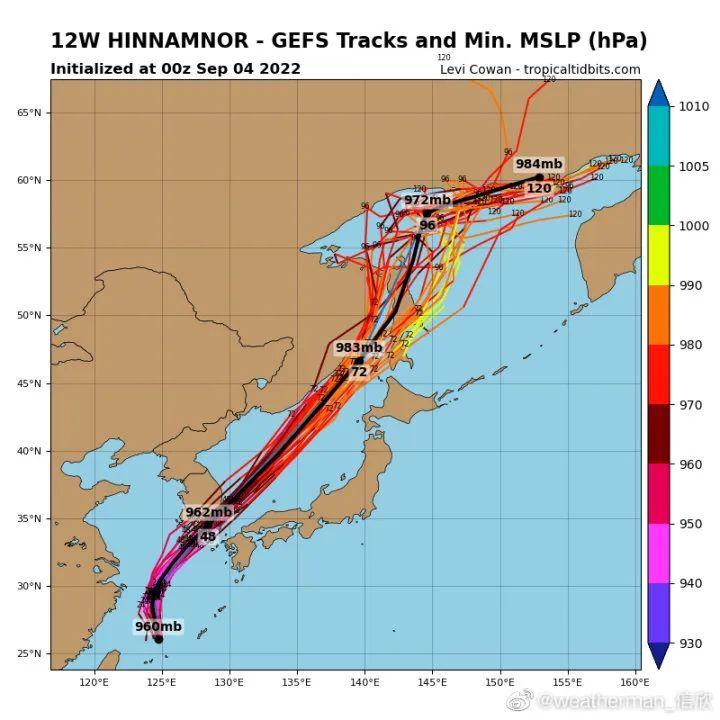
Although Xuan Lannuo did not land in my country, Xuan Lannuo's huge circulation combined with cold air would still bring a strong wind to the eastern sea area and Jiangsu, Zhejiang and Shanghai coast. There may be heavy rain in the Siming Mountains at the junction of Ningbo Shaoxing, Zhejiang. On 6-7, after the typhoon went north, it may merge into the cold vortex system in the west wind, which led to significant rainfall in eastern Jilin and the eastern and northern parts of Heilongjiang.
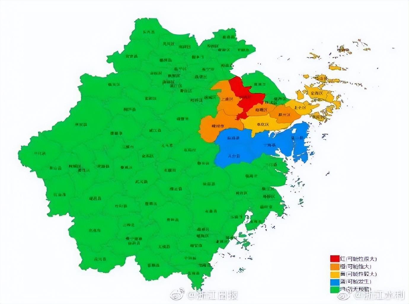
Zhejiang issued a red warning of flood disasters
The possibility of flood disasters in Yuyao is very likely
Zhejiang Province Water Resources Department and Zhejiang Meteorological Bureau September 04, 2022 jointly issued the red warning of the mountain flood disaster: It is expected to have a great possibility of mountain flood disasters in Yuyao City at 20:00 on the 4th (red warning) , Haishu District, Lizhou District, Shangyu District, and Puzhou City are likely to occur in mountain flood disasters (orange warning), Beilun District, Fenghua District, Dinghai District, Putuo District, Shan County, Shengsishan County, which is more likely to occur in mountain flood disasters (yellow warning ), Xiangshan County, Ninghai County, Xinchang County, and Tiantai County may occur (blue warning). Please pay close attention to the changes in the weather situation and rainwater, and pay attention to preventing mountain flood disasters caused by heavy precipitation.
Hangzhou Public Security Traffic Police warm reminder:
Affected by the typhoon "Xuan Lannuo", the peak (September 5th) on the first week of school (September 5) will spend the rain in rainwater. According to previous experience, the traffic traffic capacity of the city will decrease by 10%. So today's peak (September 5), everyone must go out in advance.
Affected by the typhoon, before the departure, the drivers pay attention to check the car condition and replace the wiper in time. Driving on rainy days or slippery roads, please keep the windows and reflector clear, control the speed of the car, keep a safe distance from the front car to avoid emergency braking and steering, so as to prevent the side danger from slipping on the car.
When encountering heavy rain, if the effect of the wiper cannot meet the requirements of visibility, do not risk driving. You should choose to park at places that do not affect traffic and safety, and turn on the hazard warning light.
"Xuan Lannuo" is dragging and pulling
It's simply rushing
According to Hangzhou Meteorological Observatory
Starting this afternoon
Hangzhou will turn into a cloud -based weather

Source: Qianjiang Evening News The All -Media Editorial Center is comprehensive from Zhejiang News, Central Meteorological Observatory, Ningbo Meteorological, Ningbo Evening News, Zhejiang Water Conservancy, Qianjiang Evening News, Correspondent Yang Yifan, Zheng Yijiong
Source: Qianjiang Evening News
- END -
[Reminder] The latest adjustment of Wuhan bus line!

Wuhan City Transportation Bureau issued an announcementDue to Hongqiqu Road Compre...
Wang Xiaoyou founded Wang Xiong: When net red is not a bad thing

The other side of the big is fragile: the supply chain of the enterprise is not so...