Typhoon "Xuan Lannuo" continues to go north!There are more rainfall in the southwest!丨 weather outlook
Author:China Meteorological Administr Time:2022.09.05

New weekly opening
Local weather
Still unable to calm down
today
Typhoon "Xuan Lan Nuo"
It will move north to northeast
Strong strength maintains super typhoon level
(Level 16, 55 meters/second)
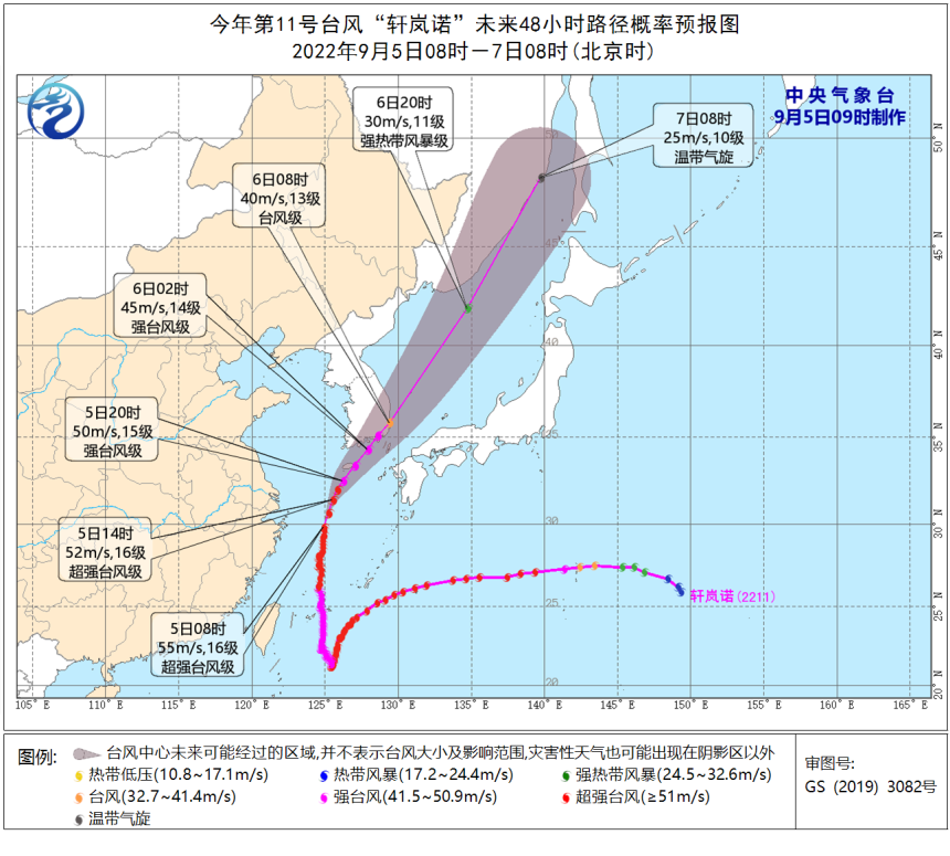
It is expected that the intensity of "Xuanlan Nuo" will gradually weaken in the future
Morning to the morning
Log in or wipe the coast of southern South Korea
After entering the sea of Japan
Quickly move in the northeast
And gradually become a green cyclone
Affected by it
Today, the coast of the Yangtze River Delta area today
There will be windy weather
Central Meteorological Observatory continues to release
Typhoon yellow warning
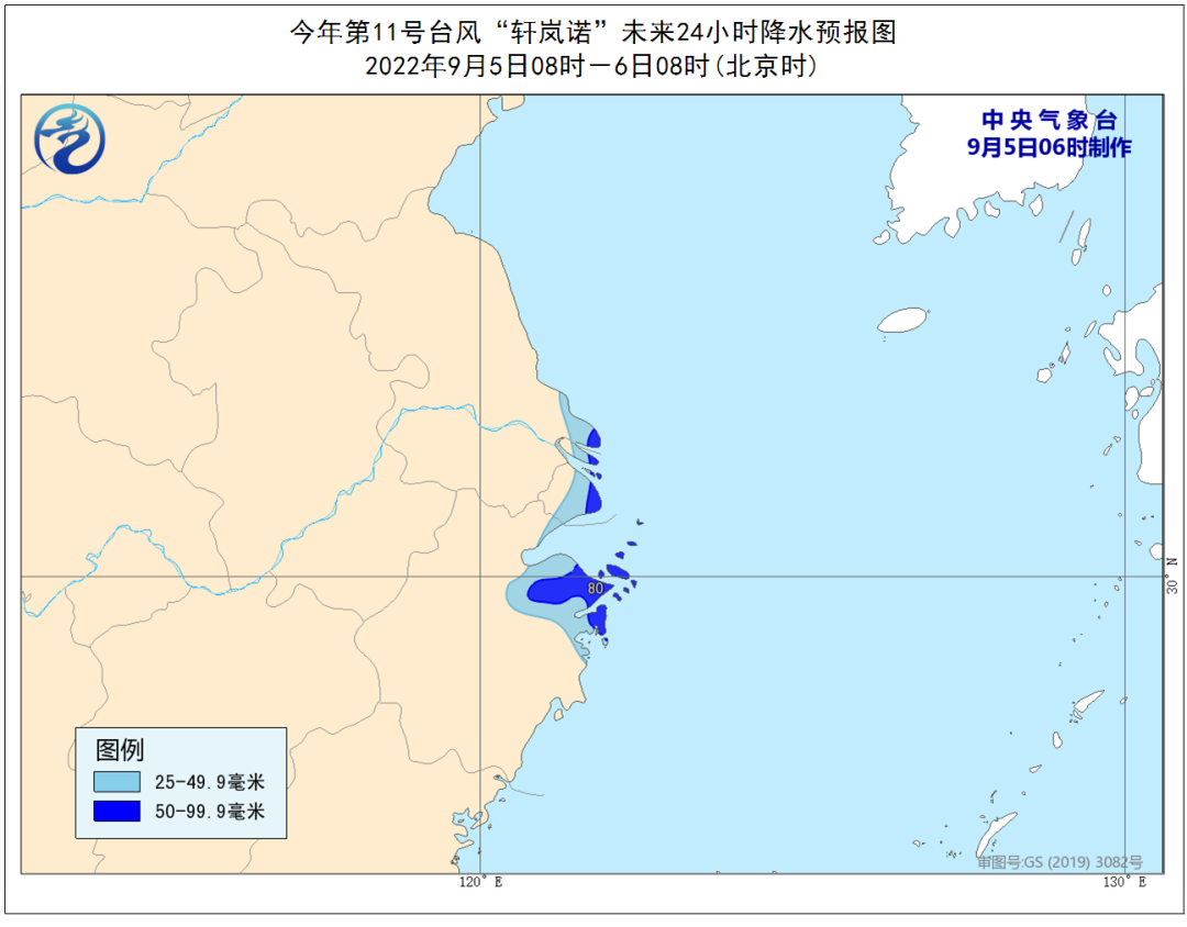
Dafeng Forecast: September 5th to 08:00 on the 6th, the bus strait, Taiwan ’s east ocean, the middle of the East China Sea, the middle of the Yellow Sea and the south, the sea near the Diaoyu Islands, the Yangtze River Estuary District, Hangzhou Bay, the coast of Taiwan Island, northeast Zhejiang, Shanghai, Shanghai, Shanghai, Shanghai, Shanghai, Shanghai, Shanghai, Shanghai, Shanghai, Shanghai, Shanghai, Shanghai, Shanghai, Shanghai, Shanghai, Shanghai , East and coastal of Jiangsu will have 6-9 strong winds, and the gusts are 10-11. Among them, the wind of most of the East China Sea, the southern Yellow Sea, Hangzhou Bay, and the northeast of Zhejiang are 10-12, and the gusts are 11-13. "Xuan Xuan The wind on the nearby sea of Lannuo's "Lannuo" center is 13-16, and gusts can reach level 17 and above.

Precipitation forecast: September 5th to 08:00 on September 5th, southeast Jiangsu, northeast Zhejiang, and Shanghai have middle to heavy rain. Among them, there are heavy rain in northeast Zhejiang, Shanghai, southeast Jiangsu (50-80 Millimeter).
As the typhoon turns to the northeast
The precipitation in East China has weakened
It is expected to be from the night of the 5th to the 6th
"Xuan Lannuo" on the north will be with the cold vortex of the Northeast
Commonly affecting the Northeast China
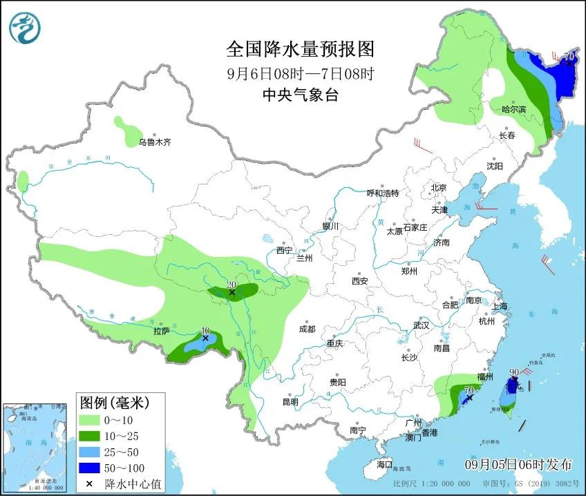
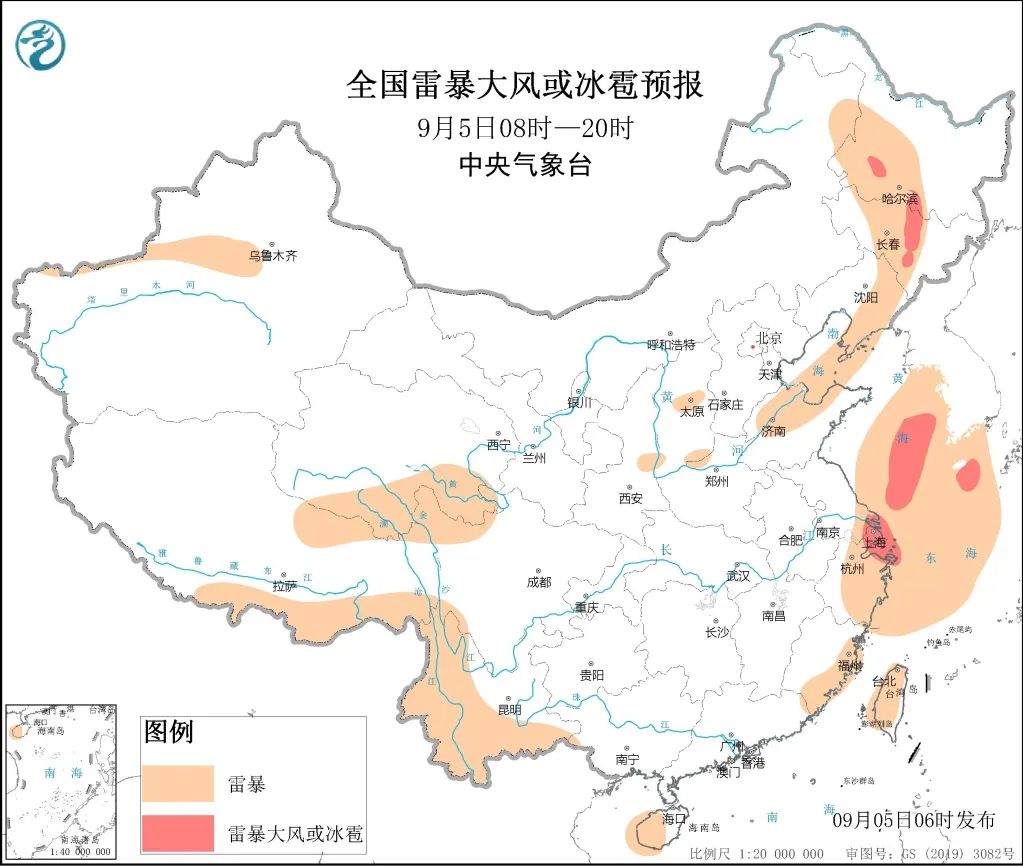
There are middle to heavy rain in eastern Jilin, eastern Heilongjiang and other places. In addition, due to the cold vortex, during the day on the 5th, there were convective weather in the central part of the Northeast region. Land in south of Heilongjiang and central Jilin need to be alert to thunderstorms or hail.
in addition
One week
There are more rainfall weather in the southwest

It is expected that this two days (5th to 6th), Tibet, southern Qinghai, western Sichuan, western Yunnan and other places will be small to middle rain. Among them, there are rain sandwiches in northern Tibet and southern Qinghai. There are heavy or heavy rain in western and southern Yunnan.
From the 7th to 9th, there will be small rain and heavy rain in the central and eastern parts of Tibet, southern Qinghai, east, Sichuan, Yunnan, and South China.
Reminder
Affected by Typhoon "Xuan Lannuo"
There are heavy rainfall weather in Ningbo, Shaoxing and other places in Zhejiang
The risk of geological disasters in the local area is high
Northeast Zhejiang, Shanghai
East Jiangsu and coastal winds are strong
Please pay attention to prevention
Produced by China Meteorological Administration Xuanke Center (China Meteorological News Agency)
Source: Central Meteorological Observatory
Edit: Zhang Linhao
Review: Duan Haoshu

- END -
Huangpu District Meteorological Observatory issued a thunderstorm and windy yellow warning [III clas
At 07:10 on June 09, 2022, the Huangpu District Meteorological Observatory issued a thunderstorm and windy yellow warning signal in various streets in Huangpu District.
The list of famous teachers and principals of Jiuquan City, these individuals are on the list!
About 2022 Jiuquan City Famous Teacher Name PresidentAnnouncement of selection recommended candidatesAccording to Jiuquan Education Bureau, the Municipal Human Resources and Social Affairs Bureau, and