Super typhoon approaching!The red alarm sounds!Stop work!Swina!Stop class!
Author:Chinese anti -cult Time:2022.09.05

At around 11 am on September 4th, Typhoon Xuan Lannuo, No. 11 this year, strengthened its level to super typhoon. As it approached step by step, my country has entered the main time period of Typhoon "Xuan Lannuo". Although "Xuan Lannuo" does not land in my country, its circulation is huge, and it will be combined with cold air. The wind and rain are widely affected. East China and even the Northeast will be affected.
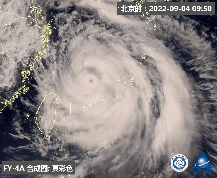
It is expected that "Xuanlan Nuo" will move north at a speed of 15-20 kilometers per hour, and the intensity will be enhanced. It will gradually approach the sea in northeast Zhejiang. It started to move to the northeast morning in the morning and tended to the southern Korean Peninsula to the area of the Korean Strait.
Affected by "Xuan Lannuo", there will be strong wind and rain along the coast of East my country, and there will be heavy rain in the northeast of Zhejiang. In addition, the number of cold air in North China, Northeast and other places in the north will also increase.

Ningbo, Zhejiang, depending on Hong Kong -sheltered ships. Picture of Ningbo Maritime Affairs Bureau
"Xuan Lan Nuo" is getting close
Zhejiang released a red warning of the waves
At 10:00 on the 4th, the Zhejiang Marine Monitoring and Forecast Center issued a red warning and a yellow alert of storm in the "Emergency Plan for Marine Disasters".
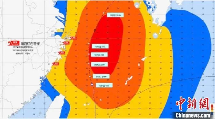
The waves of waves issued by Zhejiang Province. Photo Conferry of Zhejiang Marine Monitoring Forecast Center
According to the storm wave issued by Zhejiang Marine Monitoring and Forecast Center at 10 o'clock, due to the influence of "Xuan Lannuo", it is expected to increase the water by 50-100 cm along the coast of Zhoushan on the 4th to the 5th. -120 cm storm increases. Ningbo storm warning level is yellow; Zhoushan storm trendy warning level is blue.
In Zhejiang's offshore waters: Hangzhou Bay is from 2.0 meters to 3.0 meters in the middle to large waves, and it will increase to large waves from 3.0 meters to 4.0 meters at night; there are 6.0 meters to 8.0 meters of wild waves in northern Zhejiang, which increases to 8.0 at night to 8.0 The mad waves from rice to 10.0 meters to the madness; the central and southern parts of Zhejiang have 8.0 meters to 10.0 meters of mad waves, and the sea surface passes by the typhoon center will appear more than 12 meters. The warning level of the sea waves in the sea is orange.
In the waters of Zhejiang near the shore: Jiaxing has 1.6 meters to 2.5 meters in the middle to large waves, and it increases to large waves from 2.5 meters to 3.5 meters at night; Zhoushan and Ningbo are from 3.5 meters to 5.0 meters. Mi to 6.0 meters of giant to mad waves; Taizhou and Wenzhou have 4.0 meters to 6.0 meters of giant to mad waves. Near -shore sea wave warning levels are red.
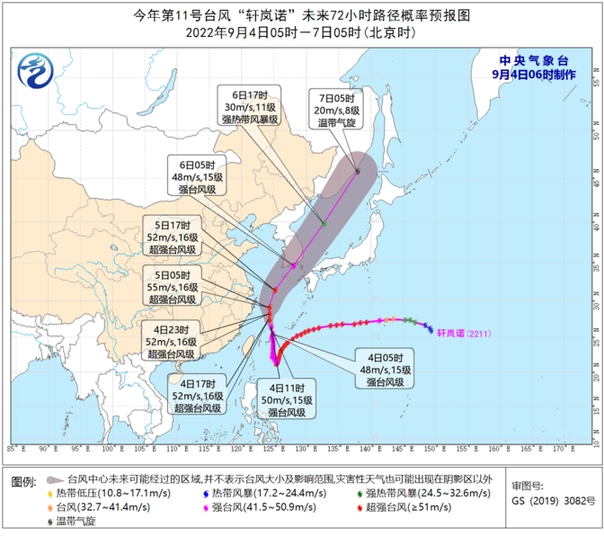
Typhoon No. 11 this year "Xuan Lannuo" in the next 72 hours path probability forecast chart
There are so many places to heavy rain
Some sea gusts can reach level 17 or more
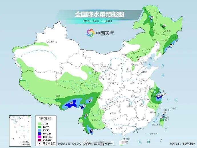
Affected by "Xuan Lannuo", the coast of East China has obvious storms. Since September 1st, rainfall in northern Taiwan, Zhejiang, Shanghai, southern Jiangsu and other places has increased significantly, and heavy rain or heavy rains. In the eastern part of Shandong and southern Liaoning, there was also a strong rainfall under the joint influence of the typhoon water vapor transportation and the eastward movement of the northern high -altitude slot. Davids appeared in the local area of Weihai and Rongcheng.
From 8:00 on September 4th to 8:00 on 5:00, there were heavy rain in northeast Zhejiang and northern Taiwan Island. Among them, there were heavy rainstorms (100-120 mm) in the northeast of Zhejiang. In addition, there will be heavy rain (25-40 mm) in southern Liaoning and southern Jilin.
On the 5th, "Xuanlan Nuo" turned to the northeast movement, which weakened the impact on the precipitation of the eastern coastal areas. By the heavy rain, the territorial heavy rain.
Source: China Weather Network
The Central Meteorological Observatory predicts that due to its influence, in the next three days, Taiwan will be in the east, the East China Sea, the East China Sea, the Diaoyu Islands, the Yangtze River Estuary, Hangzhou Bay, Zhejiang coast, Shanghai coast, and southeast of Jiangsu. "The nearby sea surface passed by the center is 13 ~ 16, and the gusts can reach level 17 or more.
Discontinue work, suspension, and suspension!
At present, Zhejiang Province has initiated a level IV emergency response of geological disasters. More than 1,1600 fishing vessels in maritime operations have all returned to Hong Kong, and more than 670 leisure fishing vessels have been suspended.
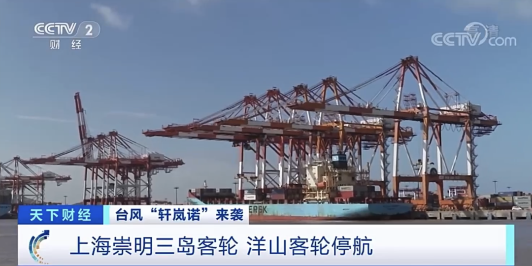
On the afternoon of the 3rd, the passenger ships and Yangshan passenger ships of the Chongming three islands in Shanghai have been suspended. Huangpu River tour ships and ferries will take measures such as suspension and wind from the situation. 332 ships.
In addition, the Ningbo, Zhoushan, and Wenzhou Education Bureau issued an emergency notice and affected by the super typhoon "Xuan Lannuo". The impact of the winding wind will be resurrected.
The National Defense Administration to improve the emergency response to flood prevention and typhoon prevention to the third level
In view of the "Xuan Lannuo" will seriously affect my country, in accordance with the relevant provisions of the "National Flood Control and Drought Resistance Emergency Plan", the state defense decided to increase the emergency response of flood prevention and typhoons to the third level on September 3, and on Typhoon Defense work is arranged and deployed.
At present, the two working groups of the National Defense Office have assisted in guidance and guidance of flood prevention and typhoon in Zhejiang and Jiangsu provinces.
CCTV Finance "The World Finance" column video
"Xuanlan Nuo" arrives in Okinawa, Japan
More than 3,000 residents stopping power outages
According to Xinhua News Agency, Typhoon Xuan Lannuo, No. 11 this year, arrived on the 3rd of Ishigaki and Miyagaki, Shigaki City, Okinawa, Japan. As of the evening of the 3rd, typhoons have caused more than 3,000 households in the two cities.
On the 3rd, the Okinawa County Government issued a shelter instruction to approximately 109,500 people living in Ishigaki and Miyaguda. As of that night, except for a 70 -year -old woman in Naaba, there was no other casualties.
According to the forecast of the Japanese Meteorological Agency, from the night of the 3rd, Typhoon moved north from Ishigaki Island all the way to the north, and began to turn eastward on the 5th. It is expected to reach the Kyushu area on the 6th. The Japan Meteorological Agency has issued alarm, large waves, heavy rain, mudslide disaster and other cities along the coast of Japan and Pacific coast.
This article is reproduced from the WeChat public account "China News Agency". Source: China News Agency integrates from China News Network, China Weather Network, CCTV Finance, Xinhua News Agency, Qianjiang Evening News, CCTV News Client, etc.
not
- END -
Taiyuan Xinzhou issued a business license named "Shanxi Taixin Integration Economic Zone" on the same day

On July 15th, the Administrative Examination and Approval Service Administration o...
The South Jiao Passenger Station of Urumqi will be transformed on August 1st, and 28 passenger routes are diverted

On July 14, the 28 car routes at the Nanjiao Passenger Station of Urumqi City were...