Typhoon is also greedy?Will the super typhoon "Xuan Lannuo" be strengthened again?
Author:Institute of Physics of the Ch Time:2022.09.05
On the weather stage this year, the performance of typhoons seemed to be active. Before August 20, there were only 8 typhoons (12 historical average), and only two (3-4 historical average) were available in my country. Among the top 8 typhoons, only Typhoon No. 1 "Maleka" reached a strong typhoon level. Typhoon No. 3 "Siaba" reached the typhoon level. Others are some "miscellaneous fish" typhoons. The structure is loose and the history of life is short. This is because the absolute protagonist of this summer is the unprecedented and powerful subtropical high pressure. It brings the first high -temperature red warning in my country. The large area on both sides of the Yangtze River has undergone two months of heat. The minimum temperature record of the day is also crazy. The powerful subtropical high pressure almost runs the north hemisphere. Under its strong control, many typhoon embryos have died. The typhoon that barely generates can only disappear in the smoke.
Two "strange species": Typhoon No. 6 "Cui Si" and Typhoon No. 7 "Mulan". If you don't say this is a typhoon, who can recognize it?
However, since August, with the number of sunshine time in the northern hemisphere, the long -term sluggish cold air has gradually begun to cheer up. In late August, the cold air had invaded most of the northern part of my country, the temperature of Xi'an quickly autumn, the Yangtze River Basin also cooled down, the subtropical high pressure was weakened. , Typhoon No. 10 "Scorpion Tiger" has formed: "saddle" passes through Luzon Island, Philippines and landed in Maoming, Guangdong; although the "Scorpion Tiger" reaches a strong typhoon level, it is harmless to human and animals. On the 26th, the degeneration was temperate cyclone.

Typhoon No. 9 "saddle" and Typhoon No. 10 "Scorpion Tiger". Finally, the shape of the typhoon gradually appeared ...
On August 28, the typhoon "Xuan Lanuo" was generated immediately. The name of "Xuan Lannuo" seems to be combined with many common names in recent years. In fact, the name comes from Laos and is transliterated by the name of a national reserve. The sudden formation of "Xuan Lan Nuo" was unexpectedly expected by major weather institutions, because the latitude was relatively high, not in the sea with good thermal conditions. In the initial forecast of the Central Meteorological Observatory, "Xuan Lannuo" was considered to dissipate quickly after three or four days westward, and the intensity was only a tropical storm (level 8-9) level.
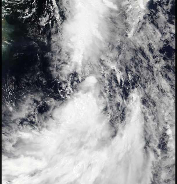
On the 29th, "Xuanlan Nuo" was unexpected again, and the small body was small. Move to the west steadily; at the same time, there is a tropical disturbance 98W activity at the same time, the structure is loose, the size is similar, and there is a trend to strengthen.
29th situation
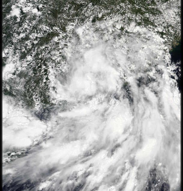
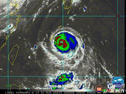
On the 30th, "Xuan Lannuo" became the first super typhoon this year. It is almost perfect, with a small and deep windy eye, which can be described as "small and powerful". The 98W is just upgraded to a tropical low -pressure 13W. Its structure is loose, but it continues to affect the path of "Xuan Lannuo", making it gradually out of the rare southwest path. Double dance ". Since then, the strong "Xuan Lannuo" has gradually "greedy" and began to absorb 13W circulation.
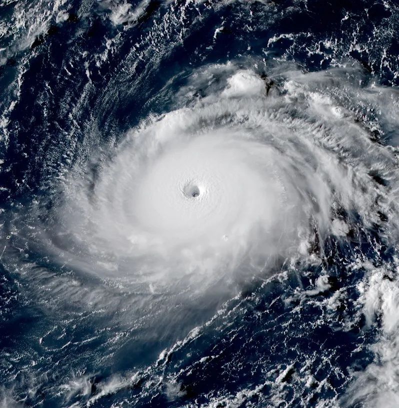
"Xuanlan Nuo" peak satellite picture

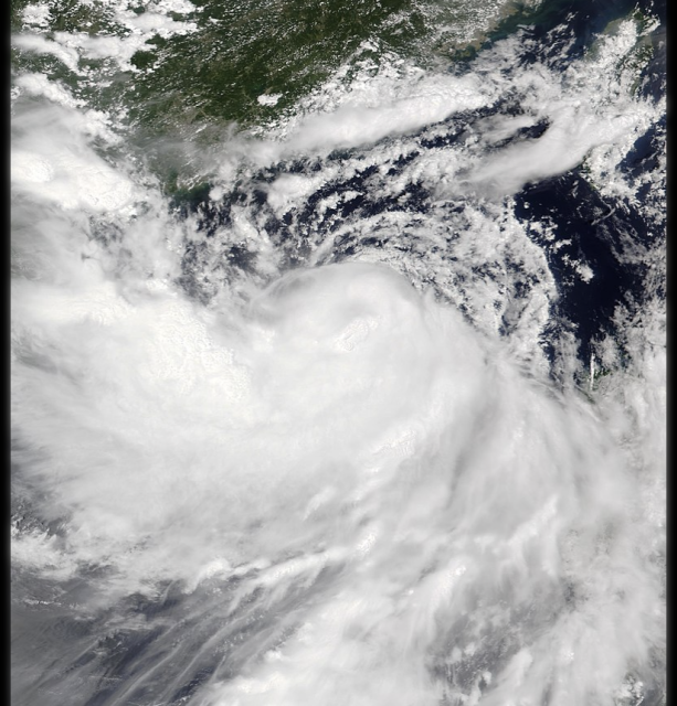
Xuan Lannuo and 13W in the early morning of the 31st satellite images
"Xuan Lan Nuo" once reached 915 hundred Papa with a small and strong body shape, with a super typhoon level of level 17 or above (65 meters/second of wind speed), which is the strongest storm so far this year. However, in the process of absorbing low -pressure 13W, it was a bit uncomfortable. This is because the 13W structure is relatively loose, but the circulation is not smaller than "Xuanlan Nuo". Its irregular wind farm has brought wind cuts to the strong "Xuan Lannuo". At the same time, the subtropical high pressure is stronger than expected. It was not completely disconnected. From the two directions of the west and north, the "Xuan Lannuo" was directly stuck to prevent it from converging with the western wind grooves in the north. In this way, "Xuan Lannuo" almost turned in place for two days. Great, but the intensity dropped straight, the structure also loosened a lot because the wind was cut, and the dry air was involved in the north side.

"Xuan Lannuo" in the early morning of September 2nd became bald, but also weakened
Because the rotation of typhoons depends on the warm surface seawater energy supply, the rotation in place makes "Xuan Lannuo" exhausted the sea water under the feet, forming a "cold water area", and the intensity of "Xuan Lannuo" is more difficult to maintain. On the 3rd, "Xuan Lannuo" weakened to a strong typhoon level (level 14, wind speed 42 meters/second) intensity. This time "forcibly mergers and acquisitions" caused "Xuan Lannuo" to hurt his vitality. Will there be the opportunity to come back in the future?
The merger process moves, the following group is a tropical low pressure 13W
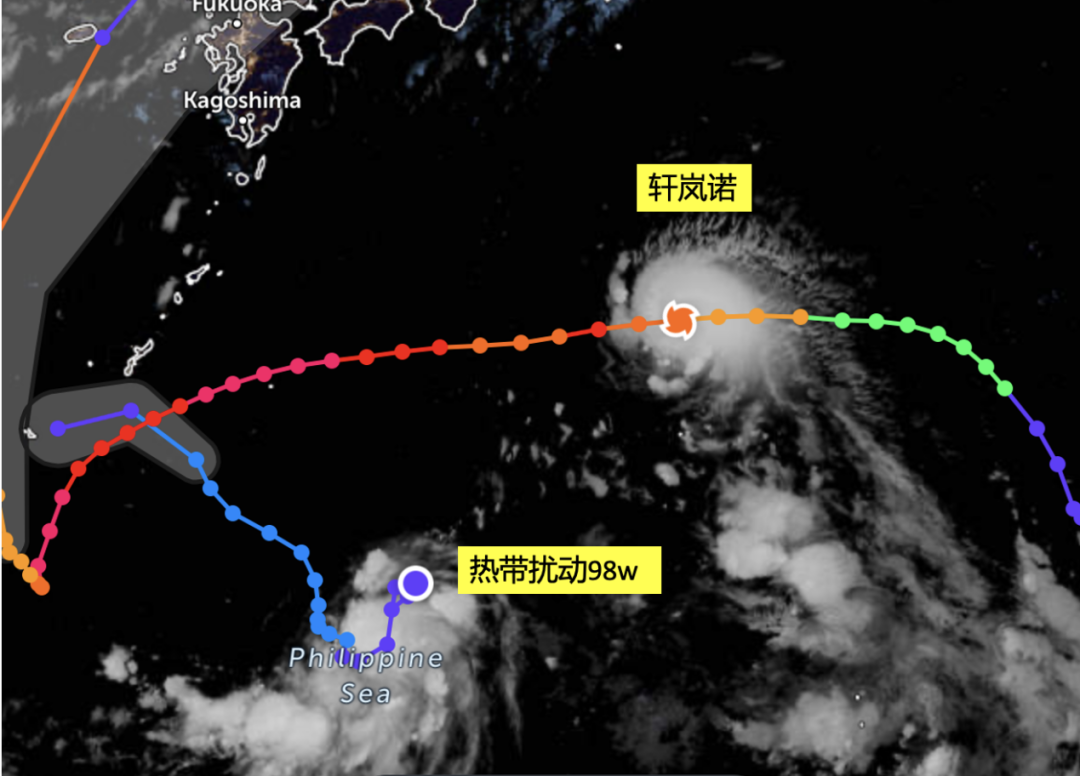
The current forecast shows that the path of "Xuan Lannuo" is more western than the previous forecast, so it will be more likely to affect and even land on the eastern part of my country in the next two days (4-5). With the adjustment of the subtropical high pressure, "Xuan Lannuo" will soon start to go north, reorganize the fanfare, and on the warm East Ocean surface, it may reinforce it into super typhoons and bring storm impact on the coastal areas of East China. In the process of "Xuan Lannuo", although the core became weakened, the overall turned into a proper giant. When "Xuan Lannuo" entered the East China Sea, the circulation will almost cover the entire East Ocean face! Therefore, personnel in related areas need to pay more attention to prevention.
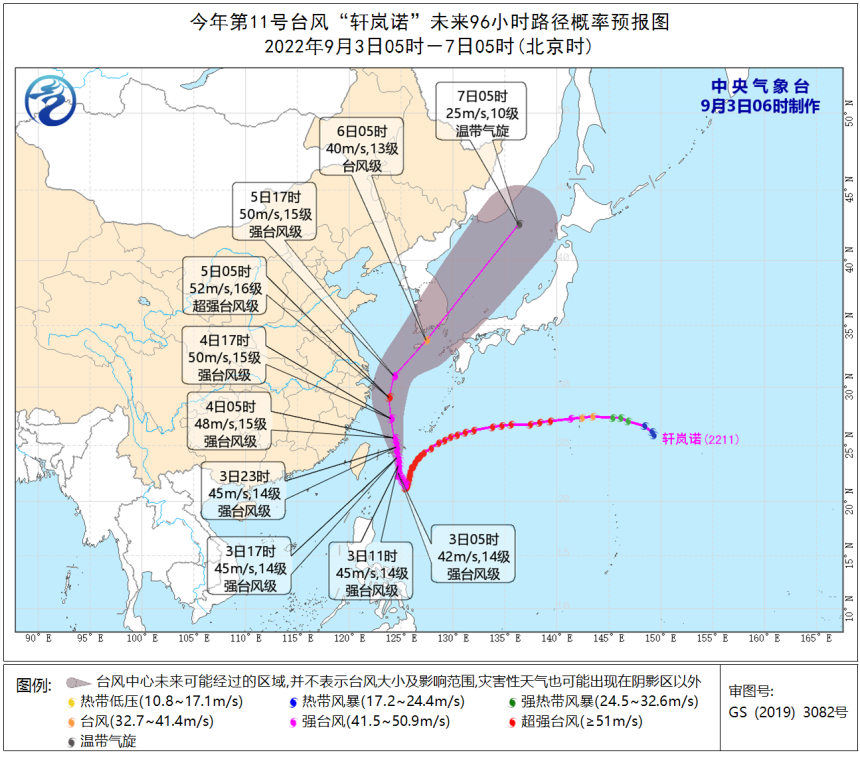
Central Taiwan path forecast
- END -
good news!There are new deployments in direct settlement of medical insurance across provinces

The two departments further promote the direct settlement of cross -province medic...
Watching 丨 Combat force to bigger and stronger new energy vehicle market

In order to enhance the competitiveness in the new energy vehicle market, many ind...