This time the Qiu Tiger is the latest news of the dry hot and super strong typhoon Xuan Lannuo Road. Today
Author:China Well -off Time:2022.09.06
This time the autumn tiger is a dry hot type
Today, a "autumn tiger is a dry hot" news on the hot search list.
According to reports, at 11:00 on September 4th, the center of Typhoon "Xuan Lannuo" No. 11 this year is located on the sea about 460 kilometers east of the south of Zhujiajian Island, Zhejiang Province, and enhanced it to a super typhoon level.
It is expected to be closest to the land on the morning of the 5th and then move to the northeast. Beginning on the 6th, the wind and rain in East China will be significantly weakened.
It should be noted that on the 6-7, the typhoon may be incorporated into the cold vortex system on the west wind. There are obvious rainfall in the eastern and eastern and northern parts of Heilongjiang, and there may be heavy rains in some areas.
This typhoon was almost like this. What I never expected was that Qiu Tiger came to "take over" ...
It is expected that high temperatures will appear from the Sichuan Basin to Jiangnan, and many places will reach 38 ° C above 35 ° C. However, this Qiu tiger is a dry heat type, and the heat will not be as high as before, and the time will not be as long as before.
Typhoon "Xuan Lannuo" will move north to northeast
The Central Meteorological Observatory continued to issue a typhoon yellow warning at 06:00 on September 5: The center of Typhoon "Xuan Lannuo" No. 11 this year (5th) is located at 5 o'clock in the southeast of Zhujiajian Island, Zhejiang Province. On the sea, the maximum wind near the center is 16 levels (55 meters/s), the lowest air pressure in the center is 930 hundred Pache, the seventh -level wind ring radius is 350 to 400 kilometers, the 10th wind ring radius is 120-150 kilometers, and the 12th -level wind circle Railway 30 kilometers.
It is expected that "Xuan Lannuo" will move north at a speed of 20 to 25 kilometers per hour, and the intensity will gradually weaken. It will move to the northeast today. Enter the sea to the northeast of Japan to move quickly and gradually become a temperate cyclone (see Figure 1).
Affected by it, from 08:00 on September 5th to 08:00, there were heavy rain in southeast Jiangsu, northeast Zhejiang, and Shanghai. Among them, there were heavy rain in northeast Zhejiang, Shanghai, southeastern Jiangsu (50 ~ ~ 80 mm). The bus Strait, the East China Sea, the middle of the East China Sea, the middle of the Yellow Sea and the south, the sea near the Diaoyu Islands, the Yangtze River Estuary District, Hangzhou Bay, the coast of Taiwan Island, the northeast of Zhejiang, Shanghai, eastern Jiangsu and the coast will have 6-9 strong winds. Level ~ 11, of which most of the winds of the East China Sea, the south of the Yellow Sea, Hangzhou Bay, and the northeast of Zhejiang have 10-12 levels, and the gusts are 11-13. The gust of gusts can reach level 17 and above.
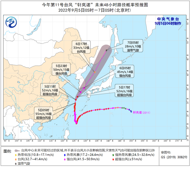
Figure 1 Typhoon No. 11 this year "Xuan Lannuo" in the next 48 hours path probability forecast chart
Specific forecast in the next three days
From 08:00 on September 5th to 08:00 on the 6th, there are rain sandwiches in the northern part of Tibet, southern Qinghai and other areas, northeast of Inner Mongolia, northern Heilongjiang, eastern Jilin, southeast Jiangsu, northeast Zhejiang, Shanghai, southwestern Sichuan There are heavy rain in parts of western Yunnan, southeast of Tibet, and other areas. Among them, there are heavy rain (50-80 mm) in northeast Zhejiang, Shanghai, southeast of Jiangsu, southeast of Tibet, and northeast of Inner Mongolia. East of Inner Mongolia, southern Jiangsu, Shanghai, northern and east of Zhejiang have levels of 5-6 or above. There are levels of 8-10 and gusts at the southern part of the Yellow Sea and Donghai (see Figure 2).
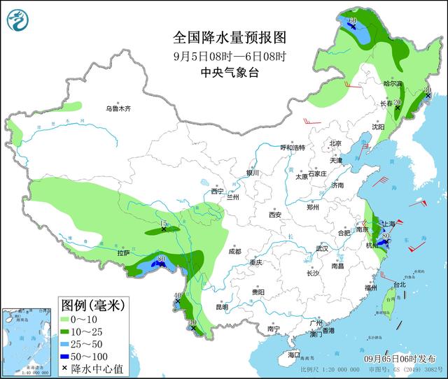
Figure 2 National precipitation forecast map (September 5th to 08:00 on September 5th)
From 08:00 on September 6th to 08:00 on the 7th, there are rain sandwiches in the northern part of Tibet, southern Qinghai, and other areas. There are middle to heavy rain in parts of the ground. Among them, there are heavy rain (50-90 mm) in the northeast of Heilongjiang, northern Taiwan Island, and southern Fujian. There are 4 to 6 winds in parts of the central Inner Mongolia, northeast Heilongjiang (see Figure 3).
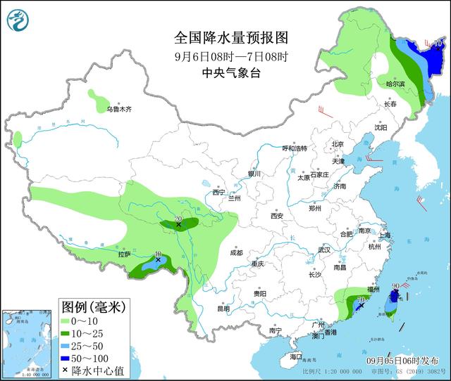
Figure 3 National precipitation forecast map (September 6th to 08:00 on September 6)
From 08:00 on September 7th to 08:00 on the 8th, there are rain sandwiches in the northern part of Tibet, southern Qinghai, and other areas. , Southern and East, Taiwan Island and other parts of Hainan Island have medium to heavy rain (25-45 mm) (see Figure 4).
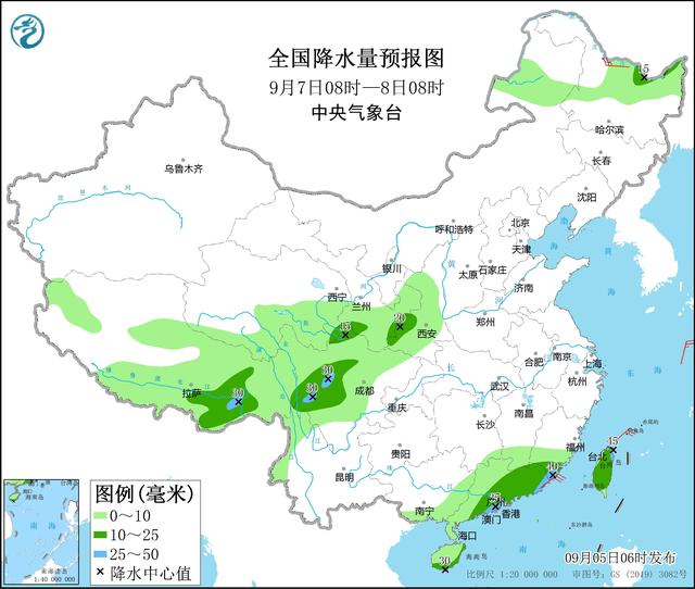
Figure 4 National precipitation forecast map (September 7th to 08:00 on September 7)
(China Xiaokang.com Comprehensive Guangming.com, the official website of the Central Meteorological Channel, Poster News)
- END -
Require rectification!Multi -place epidemic prevention practices violate the "nine inaccurate" and have been reported

The State Council's joint control mechanism held a press conference on the afterno...
Today's agricultural machinery dominate the wheat field, but we will not forget the "Mai K

Right now, summer harvest is in full swingIn order to ensure that summer grain is ...