The latest news of Typhoon "Xuan Lannuo" recently moves about 300 kilometers from the Shanghai Coast Line to move northeast
Author:China Well -off Time:2022.09.06
"Xuanlan Nuo" (Super Typhoon Grade) Center today (September 5) is located on the sea about 306 kilometers from the southeast of Shanghai Pudong's south of Shanghai Pudong at 08. The lowest air pressure in the center is 930 Hill. It is expected that "Xuan Lannuo" will move north to east at a speed of 25 to 30 kilometers per hour, and the intensity will gradually weaken. Today, it will pass by the people's square in the same latitude around 14:00, and the closest to the Shanghai Coastline is about 300 kilometers. Today, the largest inland gust of Shanghai in Shanghai is 7-9, and the coastal areas along the river are 9-11. The wind will gradually weaken in the middle of the night. Today, there are decentralized gaze or thunderstorms in Shanghai during the day. There are heavy rain in local areas.
As the typhoon "Xuan Lannuo" continues to go north. Today (September 5) rainfall will weaken the rainfall of the eastern coast. There will be heavy rain in northeast Zhejiang, Shanghai, southeast of Jiangsu, and strong sea winds on the sea. After the typhoon northward, many places in the south will be affected by the sinking air flow, and the subtropical high pressure will be strengthened to control the land again. On Thursday, there will be high temperatures in the Sichuan Basin to Jiangnan area.
Typhoon "Xuan Lannuo" north to the east coastal rainfall and weaken the rainfall in the northeast and other places
Typhoon "Xuan Lannuo" re -strengthened it to a super typhoon yesterday, and gradually approached the coastal areas of East my country in China. The influence on my country's land and offshore has entered its main time period. Under the influence of its peripheral cloud system, heavy rain or heavy rain appeared in northeast Zhejiang, eastern Shanghai, southeast of Jiangsu, and northern Taiwan Island. Grade 6-8 gusts of the eastern coast of Fujian, the eastern coast of Zhejiang, Hangzhou Bay, Shanghai, central and southern Jiangsu, and Taiwan Island, and 9-11 areas of the eastern part of Zhejiang and eastern Taiwan Island.
In order to cope with typhoon, Ningbo and Zhoushan's main passenger transport routes were suspended yesterday. Many scenic spots in Shanghai announced their closures. The passenger ships were suspended across the line. The city suspended the opening of landscape lighting.
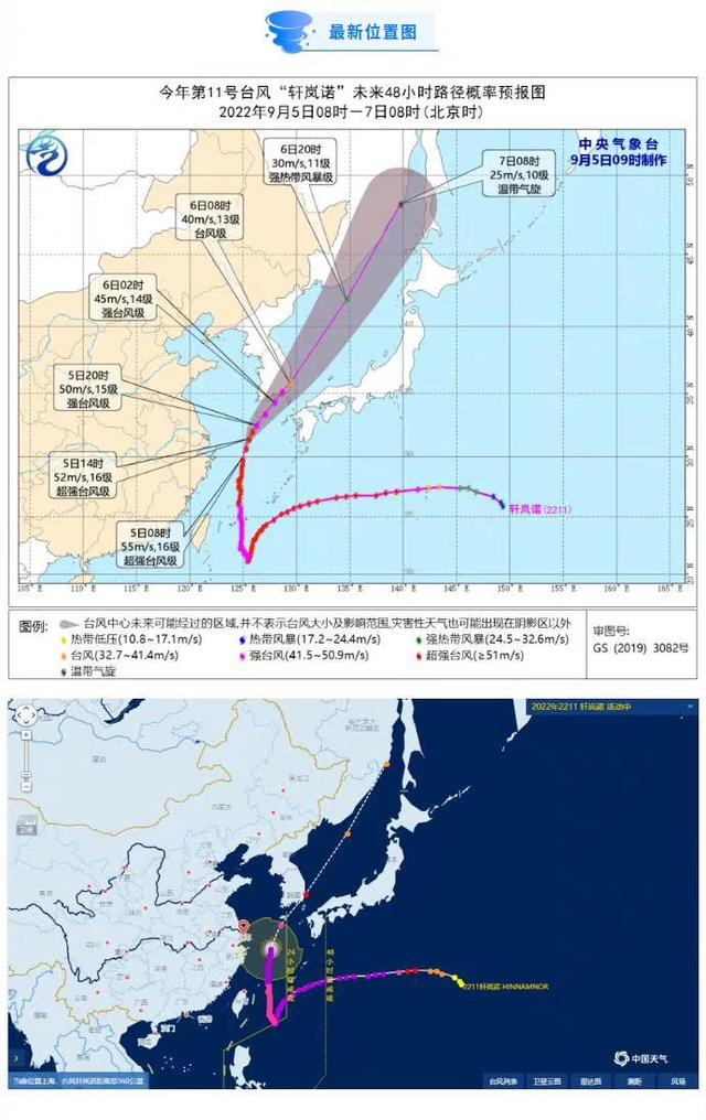
At 5 o'clock today, the center of Typhoon "Xuan Lannuo" is located on the southeast of the southeast of Zhujiajian Island, Zhejiang Province, on the southeast of the East China Sea. The largest wind near the center is 16 (55 meters/s). It is expected that "Xuan Lannuo" will move north at a speed of 20-25 kilometers per hour, and the intensity will gradually weaken. It will move to the northeast today. Enter the Japanese Sea to the northeast and move quickly and gradually become a green cyclone.
As the Typhoon "Xuan Lannuo" moves to the northeast, the precipitation in the eastern coastal areas will weaken today, because there is sufficient water vapor to continue to land on the east side, in the northeast of Inner Mongolia, northern Heilongjiang, eastern Jilin, southeast Jiangsu, and southeast Jiangsu,, southeast Jiangsu, and southeast Jiangsu,, southeast Jiangsu, southeast Jiangsu, southeast Jiangsu, and southeast Jiangsu. There are heavy rain in the northeast of Zhejiang, Shanghai, and other places. Among them, there are heavy rain (50-80 mm) in northeast Zhejiang, Shanghai, southeast of Jiangsu.
At the same time, the strong winds on the sea today are still strong. The bus strait, the east ocean, the East China Sea, the middle of the Yellow Sea and the south, the sea near the Diaoyu Islands, the Yangtze River Estuary District, Hangzhou Bay, the coast of Taiwan Island, the northeast of Zhejiang, Shanghai, eastern Jiangsu and the coast will be available. Grade 6-9 gusts, gusts 10-11, of which most of the winds of the East China Sea, the south of the Yellow Sea, Hangzhou Bay, and the northeast of Zhejiang are level 10-12, and the gusts are 11-13. The wind on the sea is 13-16, and the gusts can reach level 17 and above.
On the day after tomorrow, "Xuan Lannuo" continued to move quickly towards the northeast, and merged the transgender into temperate cyclone and cold vortex. The impact on my country will end.
In addition, due to the eastward shift of the plateau groove, the rainfall in the southwest area is frequent in the next few days. From September 5th to 6th, there are small rain in Tibet, southern Qinghai, western Sichuan, western Yunnan and other places. Among them, there are rain and snow in northern Tibet and southern Qinghai. There are heavy rain or rainstorm. From the 7th to 9th, there will be small rain and heavy rain in the central and eastern parts of Tibet, southern Qinghai, east, Sichuan, Yunnan, and South China.
The meteorological department reminds that the eastern waters, the coast of East China, and the northeast must prevent strong wind and rain weather and the possible secondary disasters. There are many rainfall weather in eastern Tibet, western Sichuan, Yunnan and other places, and need to prevent land floods, geological disasters and floods of small and medium rivers.
Typhoon yellow warning: Jiangsu, Zhejiang, Shanghai and other places in some areas of gusts 10 to 11
The Central Meteorological Observatory continued to issue a yellow warning of typhoon at 10:00 on September 5:
The center of Typhoon No. 11 this year "Xuan Lannuo" is located on the northern sea of the East China Sea in the northern sea of about 240 kilometers east of Zhujiajian Island, Zhejiang Province today (5th). The maximum wind power nearby is 16 levels (55 meters/second), the lowest air pressure in the center is 930 hundred Pache, the seventh-level wind ring radius is 350-400 kilometers, the 10-level wind ring radius is 120-150 kilometers, and the 12-level wind ring radius is 30 kilometers.
It is expected that "Xuan Lannuo" will move north to northeast at a speed of 20-30 kilometers per hour, and the intensity will gradually weaken. On the morning of the 6th to the morning of the southern South Korea, enter the Japanese sea Movement and gradually became a green cyclone.
Dafeng forecast: From 14:00 on September 5th to 14:00 on the 6th, the bus Strait, Taiwan East Ocean, East China Sea, Yellow Sea central and southern, Yangtze River Estuary, Hangzhou Bay, southeast of Taiwan, northeast Zhejiang, Shanghai, and eastern JiangsuThe coast will have 6-9 high winds, and the gusts are 10-11. Among them, the wind of the north of the East China Sea, the south of the Yellow Sea, the Hangzhou Bay, and the northeast of Zhejiang has 10-12 levels, the gust of 11-13, and the "Xuanlan Nuo" centerThe wind on the nearby sea is 13-16, and the gusts can reach level 17 and above.Defense guide:
1. Government and relevant departments do a good job of preventing typhoon rescue emergency in accordance with their duties.
2. Related water operations and past ships should return to the port to avoid wind, strengthen port facilities, and prevent the ship's anchor, stranding and collision.
3. Stop outdoor dangerous operations such as large -scale rally indoor and outdoor and high altitude.
(Tuyuan Network China Xiaokang.com Comprehensive CCTV, China Weather Network)
- END -
Yongxing Materials and Ningde Times terminated joint ventures to seek other cooperation methods
On the evening of September 5th, Yongxing Materials (SZ002756, stock price was 135.10 yuan, and market value was 56 billion yuan) issued an announcement. The two sides seek other cooperation methods a
Shanghai's enrollment interview and physical evaluation of ordinary colleges and universities in public security in 2022 -heatstroke prevention and cooling articles

Interview and physical test noticeShanghai Public Security CollegePrevention and c...