China Meteorological Administration Press Conference: In September, there will be 1 to 2 tropical cyclones that affect our country
Author:China Meteorological Administr Time:2022.09.06
On September 6, the China Meteorological Administration held a September routine press conference. Hou Yanbin, deputy director and deputy president of the China Meteorological Administration Meteorological Propaganda and Popularization Center (China Meteorological News Agency), presided over the press conference. Zhao Zhiqiang answered the reporter's question.
Core reading
The most significant feature of the climate in August is high temperature and rain. The national average temperature was the highest in history since 1961, with an average temperature of 22.4 ° C in the country, 1.2 ° C higher than the same period of the same year.
The national average precipitation was 82.4 mm, which was 23.1%less than the same period of the same year, and it was the third less in history since 1961.
A total of 500 national meteorological stations in the country exceeded the historical pole value of August. The highest temperature of 267 stations such as Chongqing Beiyi (45 ° C), Hubei Zhushan (44.6 ° C), and Sichuan Hejiang (43.6 ° C) were flat or broke through the historical extreme value.
The public needs to pay attention to preventing meteorological droughts and do a good job of forest fire prevention; pay attention to the adverse effects of West China autumn rain and cold air on energy supply, and the adverse effects of weather on agriculture; do a good job of geological disasters and typhoon disasters caused by strong precipitation.
In August, the main weather and climate events in my country
The first is that the high temperature number is extremely large, and the process of high temperature in the area continues to affect my country. From June 13th to August 30th, there are continuous and large -scale high temperature weather in the central and eastern regions of my country. This high temperature process has the characteristics of long duration, wide range, strong strength, strong extremes, and great influence. In 1961, there was the strongest meteorological observation record. In August, the average number of high temperatures in the country was 5.2 days, which was 2.7 days more than the same period of the year, and the most history since 1961. The high temperature days of high temperatures in the southwest of the southwestern southwest, central and central central China, central and southern East China, and southern Shaanxi are generally 20 to 30 days, which are generally 15 to 20 days higher than the same period of the same year.
Second, meteorological drought continued to develop in the Yangtze River Basin and other places. Affected by the continuous temperature and high rain and rain, the Yangtze River Basin occurs in a wide range of summer drought. As of August 31, the middle and lower reaches of the Yangtze River and the central and southern parts of Chongqing, the western and southeast, and the central and eastern parts of Tibet in the middle and southern Chongqing, and the central and eastern parts of Tibet. The continuous high temperature and drought have caused many mountains and forest fires in Chongqing, Sichuan and other places. The water level of the Yangtze River and Dongting Lake and Poyang Lake are significantly lower than the same year, and it has a greater impact on agricultural production, water resources and power supply in some areas.
Third, there are many regional storms. In August, there were eight regional heavy rainstorms in my country, which affected 4 processes in the north and south. Compared with the same period of the same year, the process of heavy rain in the north is 1.1 times, and the south is 0.8 times. Among them, the storms that occurred in the northern region twice from 8 to 10 and 18 to 19 have lasted for 2 days, and the intensity was strong.
Fourth, the generation and landing of typhoons are small. In August, a total of 5 typhoons were generated in the Northwest Pacific and the South China Sea, 0.7 less than the same period of the same year; two of which landed in my country, 0.3 less than the same period of the year.
Fifth, strong convection weather is more, and Yunnan, Yunnan, Inner Mongolia, is more affected. In August, a total of 5 strong convective weather occurred in the country. There were 13 provinces (autonomous regions, municipalities) in some areas suffering from strong convective weather such as lightning, heavy wind, hail and other strong convective weather. Among them, Inner Mongolia and Yunnan were severely affected.
In August, a total of 65,000 early warning information was released, an increase of 26%compared with the same period last year, and high temperature became the type of major early warning events. Among them, the number of high -temperature red early warning information accounted for 87.8%of the total number of moon red warning information.
Mid -Autumn Festival holiday weather trend prediction
It is expected that in the next ten days (September 7th to 16th), most parts of the central and eastern regions are significantly less. The amount is 40 to 80 mm, and there are 90 to 150 mm in some areas. The cumulative rainfall of the above -mentioned areas is more than the same period of the same year.
During the Mid -Autumn Festival holiday (September 10th to 12th), there were no large -scale heavy rainfall, high temperature weather and ups and downs of high temperature, and small temperatures, and generally suitable travel.
From 10th to 12th, there was a rainfall process from west to east in southern Gansu, Ningxia, central and southern Shaanxi, Shanxi, Beijing -Tianjin -Hebei, Shandong and other places. The magnitude was mainly small rain, and there were medium rain in central Shaanxi, Shanxi and other areas.
From 11 to 12, there are many rainy weather in the northern part of Xinjiang, and the magnitude is mainly small to medium rain. From the 12th, cold air will affect northern Xinjiang, which will bring 4-6 ° C to cool down. North Wind.
From 10 to 12, the southeast of Zhejiang and the coast of South China, Yunnan, Sichuan, Tibet and other places in the southern part of Zhejiang, in the southern part of Sichuan and parts of the southern Sichuan and part of Yunnan, there were medium to heavy rain.
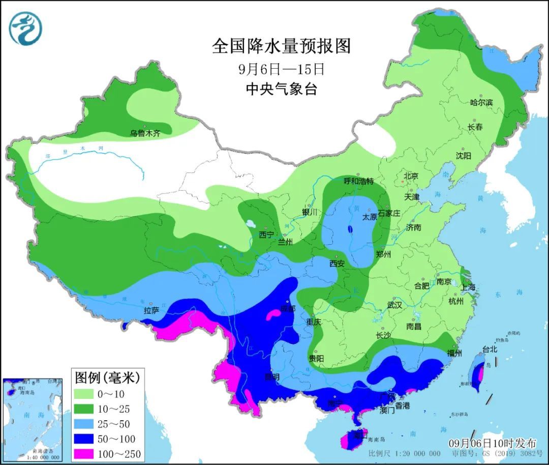
It is expected that in the next two weeks, one or two typhoons may be generated in the Northwest Pacific or South China Sea.
September national climate trend prediction
In terms of precipitation: It is expected that in September, there are more precipitation in the central and eastern parts of the northwest, north of the southwestern region, and other places in the north of the southwestern region. Among them, some areas in southwestern Shaanxi, eastern Gansu, southern Ningxia, southeast Qinghai, and northern Sichuan are more than 20 to 50 %; precipitation from the rest of the country is close to the same period of the year to less, of which central and southern Anhui, northern Jiangxi, eastern Hubei, Hunan There are 50 % to 80 % less in the northeast.
In terms of temperature: It is expected that in September, the temperature in most areas across the country is high. Among them, southern Anhui, parts of Zhejiang, central Jiangxi, eastern Hubei, most Hunan, northern Xinjiang, and western Tibet are 1 to 2 ° C. Typhoon: It is expected that in September, one to 2 tropical cyclone landing or affects my country's coastal areas.
Meteorological service reminder suggestion
The first is to prevent meteorological drought and do forest fire prevention. It is necessary to pay attention to preventing the occurrence and development of meteorological drought. Most of the East China, Central China, and northern Xinjiang are less precipitation and high temperatures. It is necessary to do forest fire prevention work at the same time.
The second is to prevent the adverse effects of Huaxi Autumn Rain and cold air on energy supply. Pay attention to the gradual relaxation of Huaxi Autumn Yu on the current situation of water conservancy power generation and the adverse effects of drought and flood transfer on energy transportation and power facilities. Inner Mongolia, Northeast, North China and other places are affected by staged cold air, and the preparations for power supply should be made in advance.
The third is to prevent the adverse effects of weather on agriculture. All localities should strengthen the management of autumn grain crops to promote the full grouting and normal maturity of crops; use clear weather to harvest mature autumn grain crops in time. Western Shaanxi, central Gansu, most of Ningxia, and northern Sichuan regions need to pay attention to preventing the influence of the influence of the autumn harvest. Southern late rice production areas strengthened water and fertilizer management and promoted the formation of late rice production. The middle and lower reaches of the Yangtze River should pay attention to the development of drought, do a good job of drought -proof and drought, and sowing and transplanting rapeseed in a timely manner. South China and Jiangnan coastal areas need to strengthen their adverse effects on agricultural and fisheries. Various places must still do a good job of monitoring and prevention of pests in the later period of crops. Northeast China pays attention to the adverse effects of staged low temperature on crop grouting.
The fourth is to prevent geological disasters and typhoon disasters caused by heavy precipitation. In September, the central and eastern parts of the Northwest, northern parts of the southwest, and eastern Tibet need to strengthen secondary disasters such as landslides, mudslides and other secondary disasters caused by strong precipitation and adverse effects on people's production and life. In September, there may be typhoon westward influenced South China or northwest to affect the eastern region, and it is necessary to prevent heavy precipitation, wind and storm waves caused by typhoons.
Fifth, the climate of most parts of the country is more comfortable, and it is recommended to arrange outdoor activities reasonably. In September, most of the nation's climate comfort can reach a more comfortable level. Among them, the western and northeast of North China, northeast, and eastern northwest areas can reach the most comfortable level in the southeast of the southwestern region. Most of Xinjiang is comfortable (cool or hot). The above areas are suitable for travel. Most of South China and southeast of Jiangnan are uncomfortable (sultry) levels. It is suggested that the public pays more attention to the national government on the premise of paying more attention to the national epidemic situation to reasonably arrange outdoor activities and travel plans.
Analysis of hot issues
1. How is my country's high temperature this year? Will there be autumn tigers in the next two weeks and will high temperature develop?
In the summer of 2022, the average temperature nationwide was 1.1 ° C higher than the same period of the same year. It was the highest history since 1961 with a complete meteorological observation record, and the number of high temperature days was the most historically. From June 13th to August 30th, a large -scale continuous high temperature weather process occurred in the central and eastern regions of my country. The high temperature duration, wide range, strong strength, and extremely extremely extreme. The comprehensive intensity was the history of the history of complete weather observation records in 1961. The strongest. Global climate warming is a climate background that causes extreme high temperature. The continuous atmospheric circulation abnormalities are the direct causes of continuous high temperature weather this year.
It is expected that in the next two weeks, there is no large -scale high temperature weather in the southern region, and the chance of autumn tigers will be small; however, from 6 to 8, there will be about 35 ° C in some areas of Hunan, Jiangxi, and southern Hubei.
2. Drought in many places in the south in the early stage, has it been relieved? Especially in the southwest region, is it possible to turn into a situation where there is too much rainfall?
Since August 25, the cumulative precipitation in Sichuan, Sichuan, Sichuan in the southern arid areas, northern Chongqing, northeast of Tibet, south of Shaanxi, central Hubei, southern Henan, southern Jiangsu and Anhui, most of Zhejiang, eastern Fujian, etc. More than 25 mm, among which the central Sichuan and northeast, central and northern Chongqing, and south of Shaanxi have more than 50 mm, and the local meteorological drought is significantly relieved or lifted in some areas. Continue or development. At present (monitoring on September 2), southern Jiangsu, southern Anhui, most of Hubei, most Zhejiang, western Fujian, Jiangxi, Hunan, most Guizhou, northern Guangxi, southern Chongqing, southeast of Sichuan, central Tibet and other places exist It is moderate to severe meteorological drought and local drought.
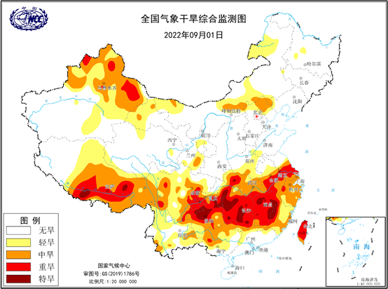
According to the forecast of the Central Meteorological Observatory, in the next ten days, most of the southwest region will have obvious precipitation process. According to the forecast of the National Climate Center, from mid -to -late September to early October, precipitation in the southwest will be 1 to 20 % more, and some areas in eastern and northern parts of the southwest may be more than 20 %. The drought in the above areas will be relieved to varying degrees.
3. Will there be less precipitation in the middle and lower reaches of the Yangtze River? If summer and autumn are drought, how should we deal with it?
Since July, the precipitation in the middle and lower reaches of the Yangtze River is significantly less than the same period of the same year. Summer drought has occurred. It is expected that the precipitation in the middle and lower reaches of the Yangtze River in the fall of the Yangtze River is significantly less than the same period of the year. The influence of forest fire risks and electricity protection. The water conservancy department needs to ensure irrigation water for grain production. Fire prevention departments in various places should closely monitor the dynamics of fire insurance and pay attention to the short -term weather forecast and fire risk forecast of the local area, and strengthen the fire prevention work of forests and grassland. The power guarantee department should pay close attention to the demand for living electricity and industrial and agricultural electricity for residents. 4. In the critical period of autumn harvest and autumn, will the recent weather affect agriculture? What do you need to pay attention to?
In the next 10 days, there is no obvious precipitation process in most parts of the central and eastern regions. The precipitation is significantly less than the same period of the same year. The precipitation in the middle and lower reaches of the Yangtze River to the eastern part of the southwestern region is still small. Agricultural drought in Jiangxi, Hunan and other places will continue, which is not conducive to the seasonal rice grouting and mature, and the late rice pregnancy spikes and cotton cracks. There are more precipitation in western Sichuan, western Yunnan and other places, which is not good for autumn harvest. There are no large-scale high-temperature weather in the south, and high temperature weather will occur in parts of Hunan, Jiangxi, and southern Hubei on the 7-8, which is slightly not good for late rice growth.
It is recommended that the Southwest, middle and lower reaches of the Yangtze River, and other places use clear weather to harvest mature autumn grain crops in a timely manner; agricultural arid areas in Jiangxi, Hunan and other places need scientifically allocated water sources to ensure that rice fields are used. In the autumn harvest of western Sichuan, western Yunnan and other places to avoid precipitation periods to reduce losses.
5. Regarding typhoons, what are the characteristics of generation, the number of landing in my country, and what are the characteristics? Will this year's Qiu Tingfeng comes fiercely?
Since this year (as of September 6), 11 typhoons have been generated in the Northwest Pacific and South China Sea, which is 3.4 less than the same period (14.4) in the same year (14.4). Guangdong) is 2.2 less than the same year (5.2). This year, typhoons have five characteristics, namely, the number of frequency of generating is small, the number of login frequency is small, but the landing location is concentrated, the strength is weak, and the dual typhoon activities are difficult to predict the difficulty and extremely extreme.
It is estimated that in the fall of 2022, there are 8 to 10 tropical cyclones (central wind ≥8 levels) in the Northwest Pacific and South China Sea, which is less than the same period (11); 2 to 3 of them may significantly affect my country, which is close to our country, which is close to perennial year. In the same period (2.3). The main influence areas are South China and the coastal areas of the eastern part.
6. Recently, the World Meteorological Organization said that this century may have appeared for the first "three peaks" La Nina phenomenon. How can I understand the "Three Peaks" Lamina, what impact will it affect my country's weather and climate?
According to the latest ENSO bulletin released by the World Meteorological Organization, this La Na incident is likely to last at least until the end of the year, becoming the first "three peaks" La Nina incident in the century. The La Nina incident usually reaches its peak in winter. Therefore, if it is expected by the World Meteorological Organization Bulletin, it will mean that the La Nina incident occurs in three consecutive winter.
Statistics show that after the La Nina incident, my country's autumn precipitation is prone to the characteristics of "North Duo Nan Shao", while the probability of low temperature in winter is high. However, the influence of La Nina on the East Asian monsoon has changed its age. In addition to the ENSO incident, my country's weather and climate will also be affected by other factors. In addition, the intensity of the La Nina incident, the space type and other indicators of the incident can cause the complexity of the weather and climate relationship with my country's weather and climate. According to the existing meteorological observation records, the "Three Peaks" La Nina incident is rare. There are not many examples (since 1950, only 1998/1999, 1999/2000, 2000/2001 "Three Peaks in the winter in three consecutive winter "La Nina incident), more in -depth research is needed.
7. What are the technical means of artificially affecting the weather? Under what conditions can it play a better role? At the end of August, artificially affected weather operations to contribute to the destroyed forest fire and drought resistance in the southwest. By September, which regions need to focus on?
Artificial rainfall operations are not artificial rainfall, nor "raining" by the meteorological department, but catalyzing clouds that cannot produce precipitation or low precipitation efficiency, and use "means" to make the rain a little bigger. For example, through the aircraft sowing, launching rockets, artillery shells, or cigarette burning smoke, etc., the catalyst is sent to the cloud layer, promoting small water droplets to quickly assemble large water droplets, like "brine tofu" The "rain drops, so that the precipitation that will not produce can be produced, thereby achieving the purpose of increasing precipitation. If you want to increase the rainfall, first there must be clouds in the sky. Without clouds, the meteorological department is also "the clever woman is difficult to cook without rice." Secondly, it is not possible to rain manually.
The cloud that can achieve artificial rainfall generally needs to meet the following conditions: First, the lack of ice nucleus or cloud tuberculosis in the cloud; the other is that the thickness of the clouds is generally greater than 2 kilometers; the third is that there must be sufficient water vapor circulation and supplement in the cloud. With good rising air flow conditions, it can accelerate the transformation process from clouds and water to precipitation; fourth is to ensure the airspace; fifth, from conditional forecasting, monitoring, solution design, command, operation to effect assessment, scientific and efficient organizations of the entire process, and efficient organizations. Essence It can be said that artificial rainfall can only be "icing on the cake", and cannot do "out of nothing."
- END -
When will Suzhou enter plum?The latest response of the Municipal Meteorological Bureau!

Fengpu Hunting Hunter PondOver rain lotus full courtyard incenseToday at 17:14We w...
State Grid Gaomi City Power Supply Company: Powering operations are not afraid of "roasting" to test the hot sun on the top of the head quickly

At 10 o'clock on August 15th, the scorching sun was in the first day. The State Gr...