"Xuan Lan Nuo" just left, and the prototype of the new typhoon was brewing again!Typhoon No. 12 may be generated around the Mid -Autumn Festival!Next, the weather in Zhejiang ...
Author:Voice of Zhejiang Time:2022.09.06
Source: Comprehensive Zhejiang Emergency Management, Zhejiang Weather, Chinese Meteorological Lovers, etc.
The copyright belongs to the original author, if there is any infringement, please contact it in time
Typhoon "Xuan Lannuo" this year passed by in the East China Sea yesterday. Zhejiang felt a wave of wind and heavy rain in many places. Then "Xuan Lannuo" began to add horsepower to the northeast. Today (September 6) Around the morning, "Xuan Lannuo" had wiped off the sea on the south of the Korean Peninsula, and quickly moved towards the northeast at a speed of 70 km/h, and was about to become a green cyclone.
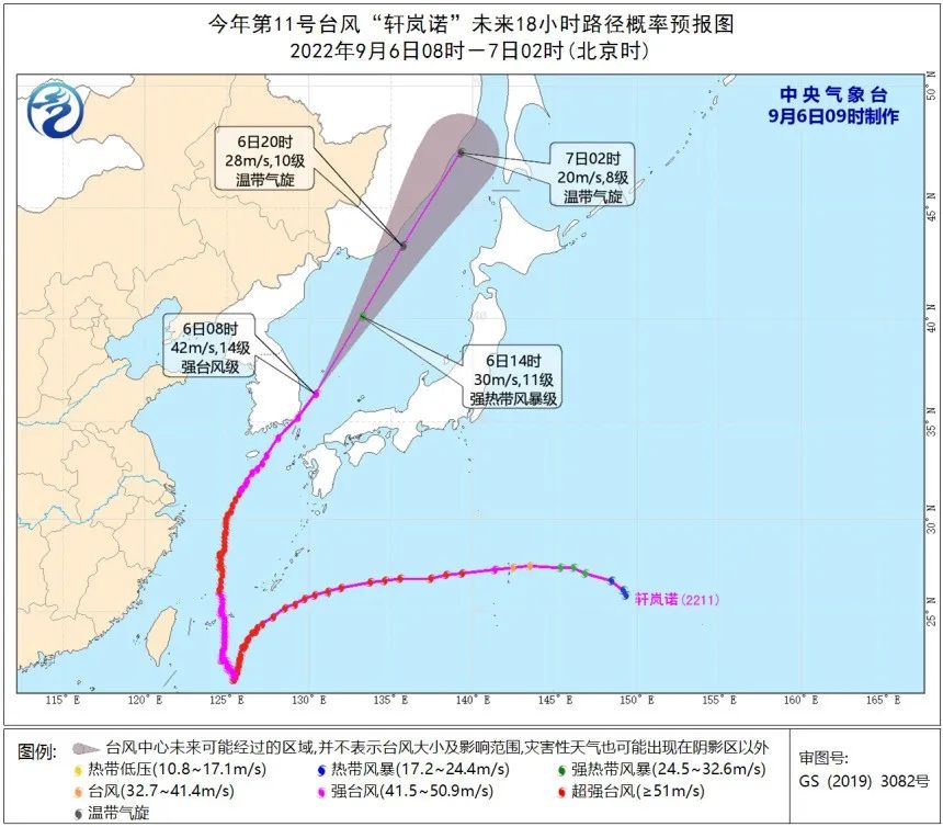
According to the "Emergency Plan for Drought Resistance in Zhejiang Province Flood Control Station", the provincial defense index decided to end the typhoon emergency response at 9:00 on September 6. This morning, there is still a high 9-11 wind in the northeast of the East China Sea. It gradually weakened to level 6-7 gusts 8 in the afternoon. Please pay attention to prevention.
What are the characteristics of "Xuan Lannuo" just away?
Typhoon "Xuan Lannuo" was generated at 14:00 on August 28th. From the afternoon of September 4th to 5th ), About 230 kilometers from Zhoushan Zhujiajian, then moved to the northeast movement, and stayed away from our province on the afternoon of the 5th.
1. Strong intensity, rare level 17 intensity in the east of our province. "Xuanlan Nuo" was strengthened to super typhoons within 36 hours after generation, maintained for 75 hours, and weakened to a strong typhoon at 05 on September 2nd. At 11:00 on the 4th, it was strengthened to super typhoons again in the south of the East China Sea. The east of the south has the strongest strength, reaching level 17 (58 meters/s, 925 hundred Pache), and it is still the super typhoon level (level 16, 52 meters/s, 935 hundred Pache) when it crosses 31 degrees north latitude. The long history of the super typhoon level in the East China Sea area is rare in history.
2. The path is complex and rare. "Xuanlan Nuo" was born to the west for nearly three days, and then fell south of the south of the Ryukyu Islands and moved south of the ocean and moved back for nearly two days. On September 2, the "V" type turned north to move north. Then move to the northeast at noon on the 5th.
3. Move slowly before entering the East China Sea, and the maritime has a long time. From September 1st to 2nd, "Xuan Lannuo" south, rotating, and less movement. On the 3rd, the speed of movement before and after entering the East China Sea was still only about 10 kilometers per hour, causing the East China Sea area for up to 5 days. Our province's coastal sea surface impact Time is about 3 days.

"Xuanlan Nuo" mobile path

Will the "Autumn Tiger" go down the mountain?
This summer, it is really a "slot". "Crazy High temperature" and "Typhoon Xuan Lannuo" have been on the stage of the weather. Xuan Lannuo has gone. Then, will Qiu Tiger go down the mountain?
Anyway, it is the end of the summer, and the previous high -temperature heat wave weather has gone forever. However, in the next, in the sunny weather, the high -temperature flames will still shine in a small area.
Tomorrow will enter the "Bailu" solar term. The temperature difference between day and night will gradually increase, and even more than 10 ° C properly. It is comfortable in the morning and evening.

In fact, this season also has a different taste. There is no hot summer heat, but the summer scenery is still retained. When there is rain, it is like a greeting in autumn. Fun ~
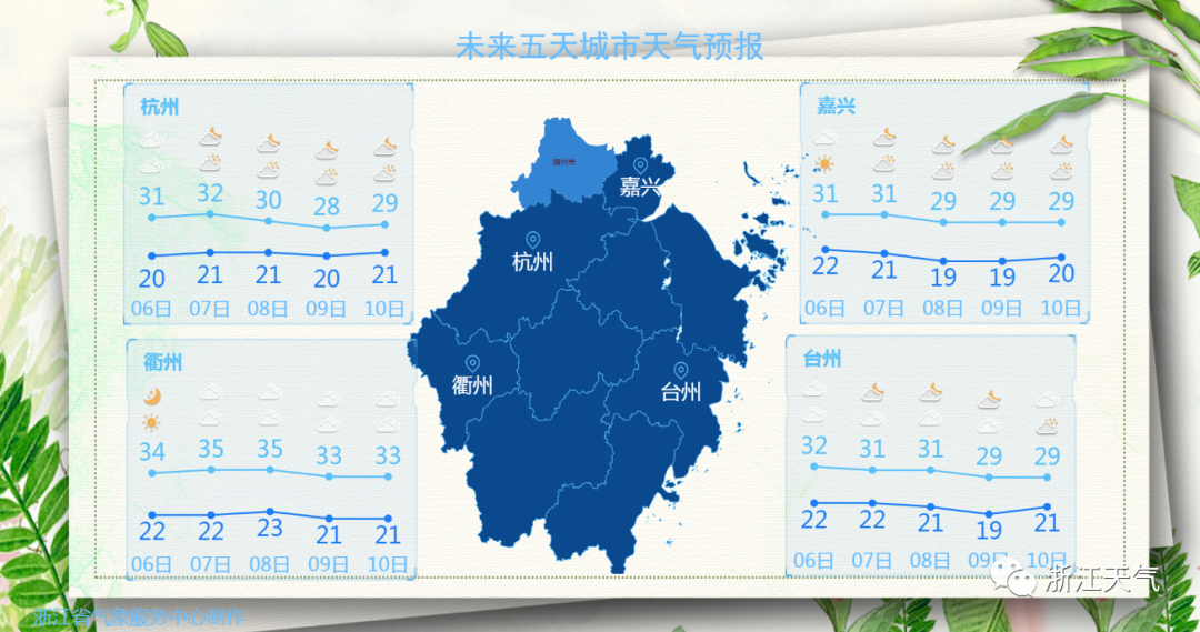
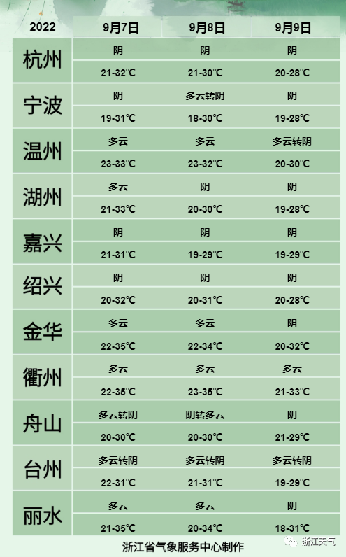
Weather forecast for the next three days

The prototype of the new typhoon is brewing
On the afternoon of September 6th, from the perspective of Fengyun No. 4 high -definition visible light satellite cloud map, Typhoon Xuan Lannuo quickly entered Japan on the afternoon of September 6 after sweeping the coast of South Korea. As the huge cold vortex has already been staring at the northeast of our country, Typhoon Xuan Lannuo's huge cloud belt has also begun to connect with the cold vortex, which means that Typhoon Xuan Lannuo is about to merge into the West Wind Belt and the cold vortex.
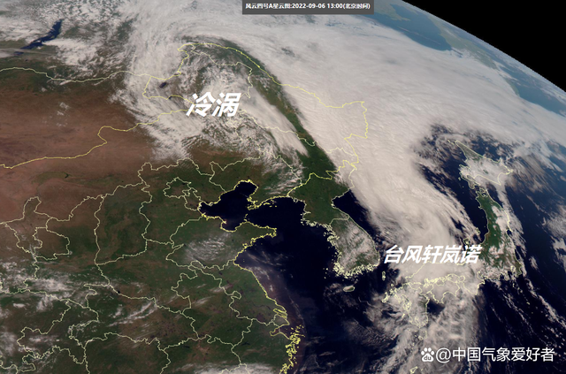
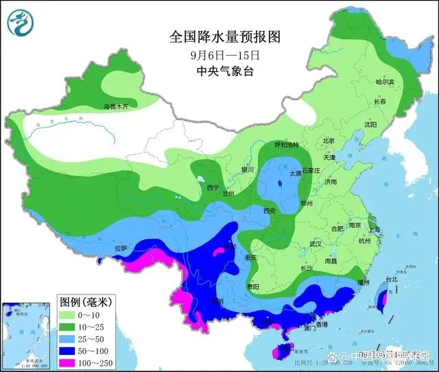
Of course, it can also be seen on the cloud map that the typhoon Xuan Lanuo on the sea on the sea is not only connected to the cold vortex, but also some cloud bands in the north side have also shrouded in many places in the central and eastern parts of Heilongjiang. The combination of typhoon+cold vortex will bring a large scale Essence The precipitation forecast of the Central Meteorological Observatory pointed out that from September 6th to September 7th, there will be a large area of heavy rain-heavy rain, accompanied by obvious winds, which may not only bring secondary disasters, but also cause harm to crops.

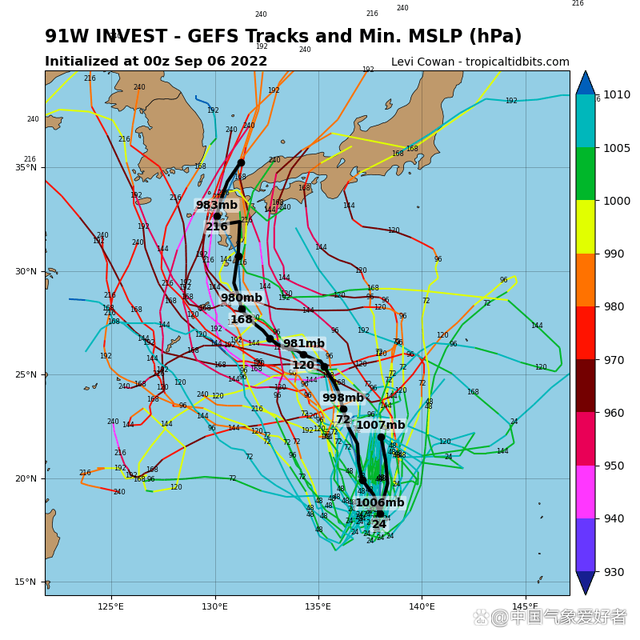
Of course, after Typhoon Xuan Lan Nuo went north, the Western Pacific is not empty. It can be seen on the high -definition visible light satellite cloud map. At present, the tropical cloud group on the Western Pacific Ocean has surged, showing that the active period of typhoon has not ended. Among them, the cloud group deep in the West Pacific has been numbered by typhoon embryo 91W and typhoon embryo 92W.
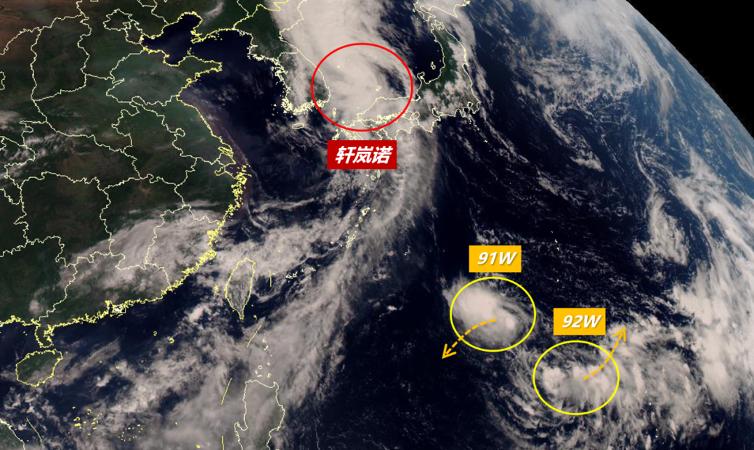
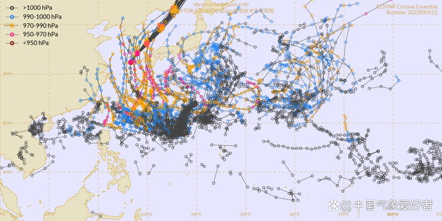
At present, many supercomputers' forecasts have pointed out that the further development of typhoon embryos has become the 12th Typhoon Plum Blossom this year. For example, the dense typhoon line in the supercomputer collection forecast is like a heavenly girl scattered flowers, showing that there is still a highly active trend in the Western Pacific.
Specifically, in the current prediction of European Super Computer, it is believed that by September 10th, the typhoon embryo east of Taiwan East my country on the Western Pacific will develop to the central air pressure 994 Baipa, which means that it will develop into a tropical storm level. It is very likely to become a typhoon plum blossom.

Of course, as the typhoon plum blossoms are about to appear, the Western Pacific is still in a large -scale adjustment period of subtropical high pressure and western wind belt. From the perspective of the path collection, the probability of the future typhoon plum blossoms is still going to Japan or South Korea. The possibility of our country is actually a typhoon with relatively erratic path trends, which shows the change of typhoons.
Of course, according to the current situation of typhoon plum blossoms to Japan and South Korea, the future typhoon plum blossoms are not necessarily a good thing for my country -the influence of Typhoon Xuan Lannuo, the just past, the influence on the rain and water of my country In terms of, Typhoon Xuan Lannuo snatched the water vapor and attracted a large amount of dry air to the south, making the central and eastern parts more dry and raining.The next -time typhoon plum blossoms may continue to interfere with rainfall in the central and eastern regions, which will increase drought in the Yangtze River Basin and other places.wx_fmt = png "data-nickname =" The Voice of Zhejiang "Data-ALIAS =" ZHEJIANGZHISHISHING "Data-SIGNATURE =" What you heard is happening. The Voice of Zhejiang, synchronize with the news. "Data-from =" 0 "0"data-is_biz_ban =" 0 " />
- END -
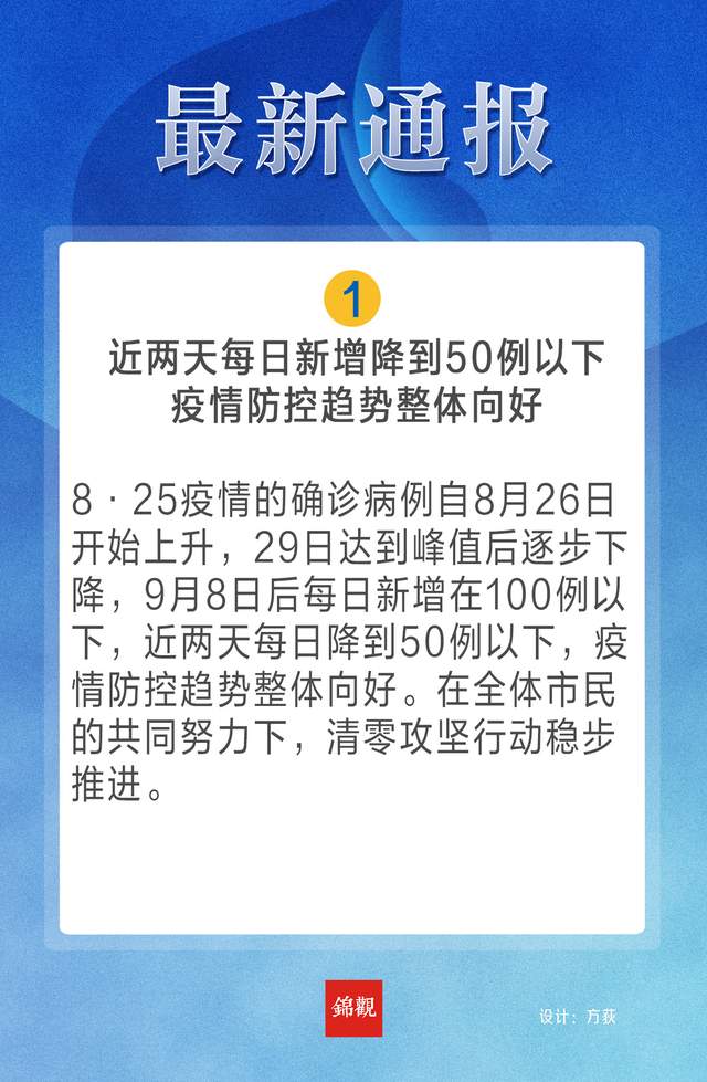
Read the picture!Summary of Information at the Press Conference of the Municipal Government News Office (September 13)
Chengdu Daily Jinguan News Design Cao Jinsong Zeng Xuerou Fang Zhao Yunru Editor H...
Xinjiang launches a three -year action plan for enforcement capabilities to enhance ecological environment enforcement capabilities

Tianshan News (Reporter Li Xing reported) Three supporting two wings of the Ecolog...