Not only people support the earthquake disaster area. The big guy in the sky must also show his skills tonight
Author:Jinan Times Time:2022.09.08
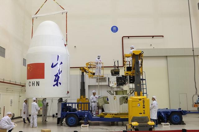
After the Sichuan earthquake, the National Space Administration launched the emergency response mechanism of the civil and commercial satellites on the local observation and data centers for the first time, and dispatched satellites such as "Qilu No. 1". On September 7, a reporter from Xinhuang River learned from Shandong Industry and Research Institute that "Qilu 1" was flying along the track in space. The satellite instructions have been bet on. It is expected that it can fly over the disaster area tonight and transmit data.

Due to the complexity of the earthquake -stricken area, the satellites such as "Qilu No. 1" and other emergency scheduling need to continue working over it for a period of time, observing and recording geological changes from different perspectives in order to make early warning. The reason why the "Qilu 1" is scheduled, because it is a radar satellite, which not only has high resolution, but also does not be affected by clouds and haze, and can work normally even under harsh climate conditions.
The "Qilu No. 1" satellite launched in April 2021, with a rail height of 500km. It is the world's first KU band radar satellite. The resolution has reached the highest level of civilian satellites. Essence It can find out major changes in global trends around the world, accurately grasp the changes in important goals, and track and monitor major crises and emergencies processes.
Putting satellites is not the purpose, and more importantly, how to use it well. Lei Bin, the head of Qilu Satellite and Deputy Dean of Shandong Industry and Research Institute, introduced that Qilu Satellite No. 1 and No. 4 has been running for more than a year. The problems such as "black sky imaging" have accumulated experience for subsequent research and development.

In July 2021, Henan's flood situation moved the hearts of the people across the country. The Shandong Industry and Research Institute Satellite Institute urgently called the "Qilu No. 1" radar satellite to obtain the image of Hebi. The comparison analysis of remote sensing images found that the large area of the Qixian section of the most important river in Hebi was flooded, and many houses, roads and farmland were covered by floods. Satellite monitoring data and analysis data are submitted to relevant departments to provide a basis for rescue and disaster relief.
"Qilu No. 1" has also helped the tap water pipe network in Shanghai Pudong and other places to "leak". The radar satellite analyzes signals such as soil water content and chlorine disinfection agent to find the leakage point of the underground water supply pipe network. Times, reduce the cost of maintenance and resources. In addition, Qilu Satellite was "physical examination" for four reservoir dams such as Xueye and Miyama in Jinan. With the networking of more professional satellites, moss and red algae on the coastline can be warned and discovered in time.
At present, Lei Bin is leading the team to build the world ’s first agricultural satellite constellation.
Shandong Industry and Research Institute has jointly developed the Qilu satellite big data platform with Jinan Big Data Bureau to provide remote sensing services for industries such as land, urban construction, agriculture, forestry, energy, disaster prevention and mitigation.
Represented by Qilu Satellite and other projects, in recent years, many high -quality projects in the empty and sky information industry have landed in Jinan, and the industrial chain has accelerated. It has helped Shandong and Jinan in the field of empty -heaven information to quickly rank among the first echelons in the country.
On September 6, the "Quancheng No. 1" two -star double star attracted attention from all walks of life, and Jinan City once again became a leader in the field of navigation satellites. After the 160 low -orbit navigation enhanced satellite network operation, the navigation accuracy will be increased from about 5 meters to 0.1 meters or even centimeters, which will meet the needs of high -precision and popularization navigation positioning in the information industry, and directly serve billions of users in the world.
New Yellow River Reporter: Wang Yingjun
Edit: Han Luying
- END -
Pengzhou Emergency: The casualties of the mountain flood personnel in Longconggou are underwriting
At 14:37 pm on August 13th, Longmen Mountain Town, Pengzhou received a meteorologi...
Situation of Hebei New Crown pneumonia on June 30
The latest notice of Hebei Health and Health CommissionAt 0-24:00 on June 30, 2022, there were no confirmed cases of new local new coronary virus pneumonia in Hebei Province; there were no new local i