The high temperature south of the West China area converges from high temperatures in the south of the south
Author:Hunan Daily Time:2022.09.08
Beginning on September 7, my country officially entered the twenty -four solar terms. During the perennial white dew, the summer wind retreated to the south of the Yangtze River, the cold air became more active, the temperature declined, and the temperature difference between day and night increased. In the next few days, the north will be high in autumn, and the high temperature in the south will converge significantly from September 8th. The West China region will sing the "main tone" in autumn and rain. Overall, the weather in my country is still more scenery.
Southwest South China Rain has a territory in Sichuan Zhen District today may be heavy rain
Yesterday, the rainfall in my country was mainly concentrated in two areas, one in the east and southwest of the northwest, and the other in the southern part of Jiangnan to the South China. During the middle to heavy rain, rainstorms in parts of the southwestern part of Guangdong, eastern Hainan Island, etc., and heavy rain in Maoming, Guangdong and Zhanjiang, Hainan Tunchang, and Qionghai.
According to the forecast, in the next three days, my country's precipitation pattern has not changed much. The overall rainfall in the north has not been in a hurry, and the autumn rain has passed by; after a few days of rest, Gansu, Shaanxi, Sichuan, Sichuan, Sichuan, Sichuan, Sichuan, Sichuan and Sichuan The rainfall of Chongqing and other places has returned, and the overall rain is not large, reflecting the characteristics of autumn rain; the rain in Jiangnan, South China and other places should be stronger, and local areas will also be accompanied by strong convective weather such as short -term heavy precipitation.
Specifically, on September 8th, there were middle to heavy rain in eastern Tibet, central Sichuan, Guangdong, Guangxi, Hainan Island, and central Shaanxi. Among them, southwestern Guangxi, southwestern Guangdong coast, and northeast Hainan Island There are heavy rain in parts of the ministry and other places.
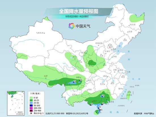
On September 9th, there were heavy rain in southeast of Tibet, southern Sichuan, Yunnan, Guizhou, Guangxi, and southern Shanxi. Among them, there were heavy rain in southeast of Sichuan, southwestern Chongqing, and northwestern Guizhou.
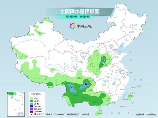
On September 10, there were medium rain in parts of the eastern part of Shanxi, Guizhou, Yunnan, and west of Guangxi. Among them, there were heavy rain in parts of western Guizhou, northern Yunnan, and west of Guangxi.
It is worth mentioning that the Sichuan earthquake area started from yesterday, and the rainwater was launched. It is expected that the rainfall process will continue until the morning of the 9th. The rainfall is mainly rainy. There are heavy rain in the area, and the rainfall at night is relatively obvious.
The meteorological department reminds that in the next 10 days, the number of precipitation daily during the earthquake -stricken area and surrounding areas of Sichuan will be more. Geological disasters in the west, western Meishan, western Leshan, northern Liangshan, etc. will be relatively high. Rescuers and people in the disaster area must be alert to rainfall and may cause secondary disasters such as landslides, collapse and mudslides.
The high temperature range of the south has obviously "shrinking" the temperature in the northeast and other places so far fluctuating
In terms of temperature, although the cold air in the north was weak after entering the white dew, the north still showed a high -air weather pattern. In the first two days of the south, the "Autumn Tiger" showed up and "Yan" value online, but from September 8th, with the increase in rainfall in the south of the river and South China, and the northern wind south, the high temperature in the south will significantly converge. Today Tomorrow will mainly have a small high temperature "head" in Jiangxi, Hunan, and Fujian.
However, under the high -spirited pattern in the northern region, the temperature fluctuations in the northeast and northeast of Xinjiang will be relatively obvious, especially in the Northeast area will be warm from cold. It is expected that the Northeast region will rise rapidly in the next few days, and the maximum temperature will rise to 28 ° C. The lowest temperature is also 17 ~ 18 ° C, and the feeling of the late summer will return. The above -mentioned regional partners also need to pay attention to the nearby forecast and increase or decrease clothes in a timely manner to prevent colds such as cold due to frequent temperature fluctuations.
[Edit: Lu Wei Tang Jiajun (Internship)]
[Source: Hunan Daily · New Hunan Client]
- END -
Wen Zhao Bank team: committed to replenishing chain for Yancheng New Energy Industry

From mobile phones to new energy vehicles, lithium -ion batteries can be seen ever...
The heavier the pregnancy, the smarter the child?Pregnant mother forbean tolerance to vomit acid poisoning
The Yangtze River Daily Da Wuhan client July 27th The more severe the pregnancy vomiting, the healthier the child is, the smarter the child. Pregnant mothers listen to folk rumors and believe that t