The "September 5" Luding Earthquake Emergency Survey released by the Chengdu Institute of Chengdu of the Chinese Academy of Sciences: Double disaster areas found a total of 855 earthquake landslides | "9 · 5" Luding earthquake
Author:Cover news Time:2022.09.09
Cover reporter Chen Yanzhang
On September 9th, the reporter learned from the Chengdu Mountains of the Chinese Academy of Sciences that after the earthquake, the Chengdu Mountain Institute initiated an earthquake emergency response as soon as possible, and set up a special science and technology disaster work class containing on -site investigation, remote sensing interpretation and platform data. Related research results were transmitted to the earthquake relief command department and on -site rescue force as soon as possible.
At present, work has been fully carried out in the earthquake area, and more than 10 key points of panoramic images have been generated.
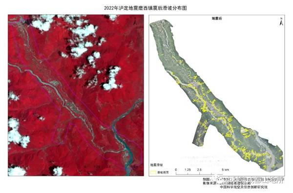
Complete the interpretation of the remote sensing remote sensing after the earthquake in Luding County after the earthquake
Using the Sichuan Surveying and Mapping Geographical Information Bureau, the China Academy of Sciences Air Sky Information Innovation Research Institute, and Chengdu Zongheng Dapeng Drum Drone Technology Co., Ltd. provided by the earthquake high-2 image and post-earthquake drone image, for the hardest hit area, Gulf Town Bay East Village 3 square kilometers and Musi Town 47 square kilometers were performed to interpret post -shock landslides. The Wandong Village survey area extracted 151 earthquake landslides, and the landslide area reached 0.68 square kilometers, accounting for about 23%of the survey area. There are many large landslides, and the projection area is more than 10,000 square meters of landslides, accounting for 17%of the total number of landslides. The Moxi Town survey area extracted 704 earthquake landslides, with a landslide area of 2.5 square kilometers, accounting for about 5%of the survey area, and 67 landslides with a projection area greater than 10,000 square meters, accounting for 10%of the total number of landslides.
According to the changes in the reflection intensity of multi -source radars such as domestic high scores, Chaohu No. 1, and other polygon radars before and after the earthquake, combined with disasters to form favorable terrain conditions, quickly interpreted 17 suspected sliding areas in the 12km*12km of the earthquake (the maximum area is approximately approximately approximately approximate It is 1.56km2) and one hidden danger on the landslide point, and 17 in Cakexiang Township in the key disaster -stricken areas interpreted 17 suspected collapse areas.
According to the 2008 Wenchuan earthquake, the Lushan Earthquake in 2013, and the post -after earthquake monitoring data of the Jiuzhaigou earthquake in 2017, the shallow source earthquake will reduce the characteristic rainfall threshold within 6 degrees of intensity. The Luding earthquake -induced in the earthquake, the Township of Musician, Decao Town, and Ya'an Ashami County, a large number of collapsed objects were collapsed, and mudslides disaster was prone to occur under rainfall conditions. Chengdu Mountain Institute jointly conducted emergency radar rainfall monitoring and early warning of flood and mudslide disaster warnings in the area of Chengdu, Chengdu Yuanwang, and Chengdu Yundao.
- END -
Hanya, Hubei: Multi -form carried out anti -drowning safety education

With the arrival of high temperature weather, in order to effectively eliminate th...
The woman cooked endangered wildlife and ate it, and also posted a videos to follow!I can't persuade
Zhang Li couldn't think of it. He just made a clip of life on the beach as a small...