Hurry up and enjoy the holidays!Typhoon "Plum Blossom" is strengthened to a strong typhoon level. It may land on September 15 or wipe over the Zhejiang coast. There are two typhoons that may be generated.
Author:Traffic Tourism Herald Time:2022.09.11
Source: China Blue News, Central Meteorological Observatory, Zhejiang Agricultural and Rural Hall, Zhejiang Weather, Zhejiang Online, etc.
The copyright belongs to the original author, if there is any infringement, please contact it in time

Today is the second day of the Mid -Autumn Festival holiday
Sunshine is super brilliant
I don't know if everyone has to go out to play
Because of this good weather
till tomorrow
It may stop abruptly
Because who?
"Plum Blossom"!
"Plum Blossom" strengthened into a strong typhoon level
May log in or wipe the coast of Zhejiang on the 15th
This Mid -Autumn Festival holiday, the typhoon "plum blossom" meets the narrow road of the annual astronomical tide. Today (11th), we strengthened into a strong typhoon in the early morning!
At 12 noon, the center of Typhoon "Plum Blossom" (strong typhoon "(strong typhoon) this year was about 385 kilometers from the southeast of Taipei, Taiwan Province, which is 22.8 degrees north latitude and 124.4 degrees east longitude. /Second), central air pressure 945 HPA. It is expected that "plum blossoms" will slowly move north at a speed of 5-10 kilometers per hour, and the intensity will not change much.
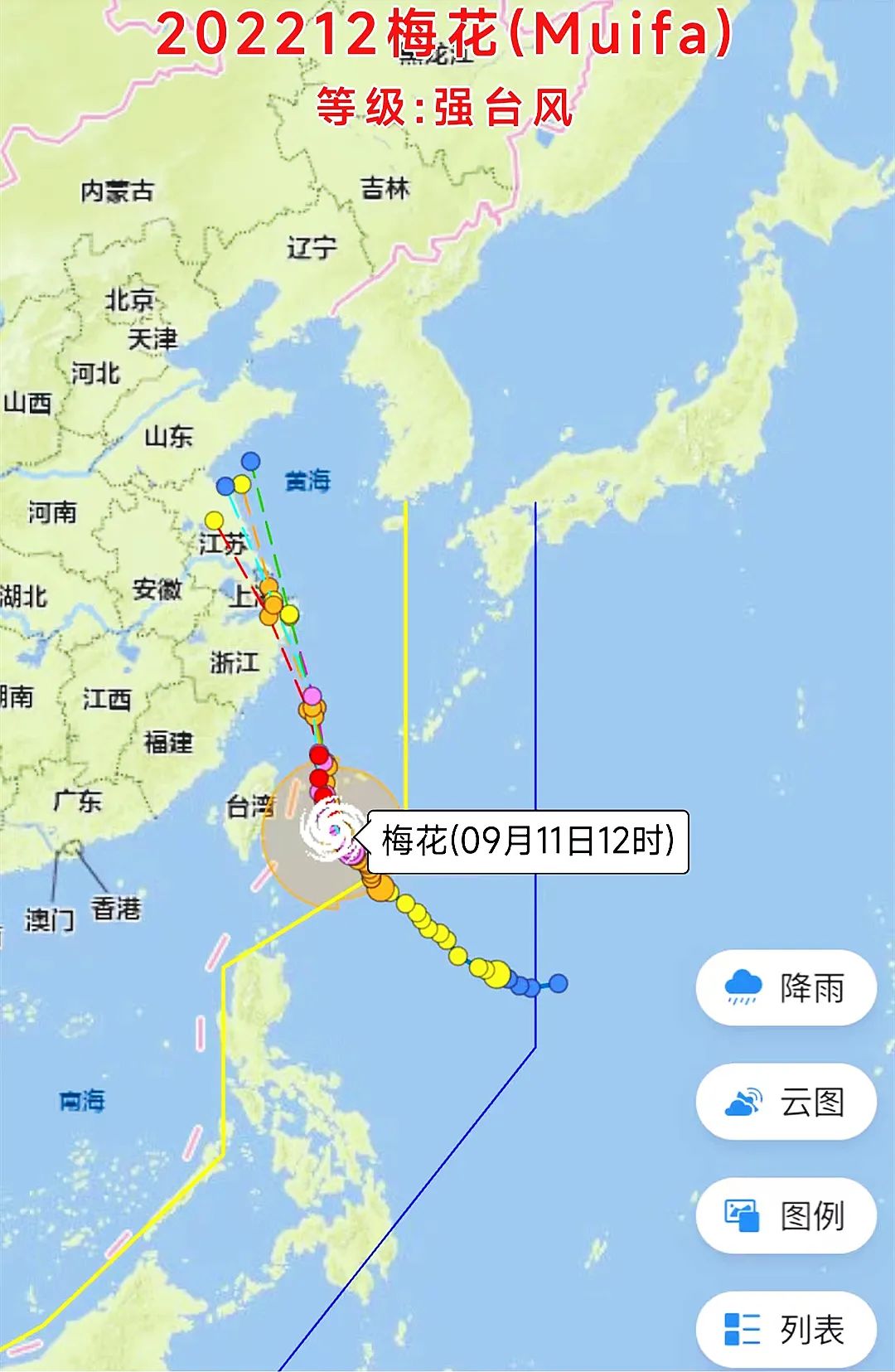
It is expected that the intensity will begin to weaken slowly on the evening of September 12, and continue to move northwest. After passing through the Ryukyu Islands, enter the southern sea surface of the East China Sea, and gradually approach the coast of the eastern part of Zhejiang. It may land on the 15th or wipe the above coastal areas.
Zhejiang waters may appear 10 meters mad waves
There are already fishing boats back to Hong Kong to avoid wind
At 10 am today (September 11), the Zhejiang Provincial Marine Monitoring and Forecast Center released the news of the storm and waves.

Affected by Typhoon Plum (strong typhoon level) No. 12 this year, it is expected that from the 13th to 15th, a typhoon storm process will occur along the coast of our province.
It is expected that from the 13th to 15th, there will be a strong storm process in the waters of our province, with a maximum of 14-15. From the waters of our province, there will be 8.0 meters to 10.0 meters of mad waves to madness.
News from the Provincial Agricultural and Rural Hall, affected by the tide and storms caused by typhoons, before 10 o'clock tonight, the fishing vessels in the province's north latitude (the junction of Zhejiang -Fujian Sea) will return to Hong Kong to avoid wind.
As of 10 am this morning, more than 70 Zhejiang fishermen who were working at 27 ° north latitude had more than 30 returning to Hong Kong to avoid wind, and the rest were in the range of home.
"Plum Blossoms" approached step by step. Today, the agricultural and rural departments of our province will further strengthen the discussions and judgments of the meteorological and natural resources departments, and further make a notice of returning to Hong Kong to avoid the wind from the north latitude of 27 ° north latitude.
From tonight to tomorrow, a large number of ships will return to Hong Kong to avoid wind. The fishing vessels will now catch the East China Sea fishing and will be concentrated in the coastal fishing boat terminals and seafood markets.
Originally, September 16th was the big day of fishing in the East China Sea. More than 19,000 fishing vessels in Zhejiang will be lifted across the board to restore maritime operations.
The relevant person in charge of the Provincial Agricultural and Rural Department said that from the current situation, due to the influence of the typhoon "plum blossoms" at sea, the East China Sea opened on September 16 this year or will be postponed.
"Plum Blossom" affects Zhejiang
May be greater than "Xuanlan Nuo"
According to typhoon monitoring, even if "plum blossoms" will not land on the coast of East China in the future, it is expected to be more west than the path of the previous typhoon "Xuan Lannuo". Although the intensity of "plum blossoms" is not as good as "Xuan Lannuo", it is closer to closer to closer The coast of Zhejiang and Shanghai, combined with the influence of cold air, is expected to have the impact of "plum blossoms" on the wind and rain of Jiangsu, Zhejiang and Shanghai.
Of course, the current "plum blossoms" are still a certain distance from us, and the uncertainty is relatively large. We also hope that "plum blossoms" is a "good typhoon" that can not be hydrated.
In the next week
Or there will be two typhoons generated
In addition to the "plum blossoms", the northwest Pacific mid -latitude ocean is also active on the two tropical disturbances of 92W and 93W. These two tropical disturbances will have a high probability to strengthen Typhoon No. 13 and 14 this year.
Especially the tropical disturbance of 92W, after ending the double typhoon interoperability effect with "plum blossoms", it has been wandering on an ocean surface nearly 1,500 kilometers from Japan. 92W will continue to move west in the next 3 days, and the strength will be gradually enhanced. In the later period, it needs to pay attention to changes in its path and strength, and the possible impact on my country.
- END -
East Axian Meteorological Bureau issued a large -wind blue warning [ⅳ/general]
At 00:52, June 08, 2022, at 00:52 on June 08, 2022, a large -wind blue warning signal: It is expected that the average wind power of the towns and streets under the jurisdiction of our county will hav
Southern County Meteorological Observatory issued a large fog yellow warning signal [III level/heavi
Southern County Meteorological Observatory issued a heavy fog yellow warning signal at 07.40 on June 10, 2022: Binjiang Street, Shubei Street, Manfu Street Office, Nantong Street Office, Laoca Townshi