Strong typhoon "Plum Blossom" gradually approach Zhejiang coast!
Author:Luqiao release Time:2022.09.11
Typhoon "Plum Blossom" No. 12 this year
Now it has been upgraded to a strong typhoon level
Typhoon

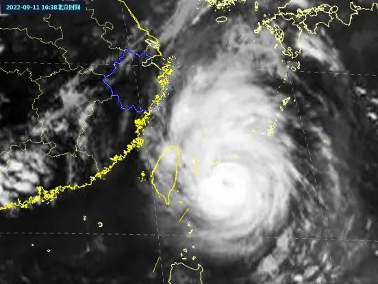
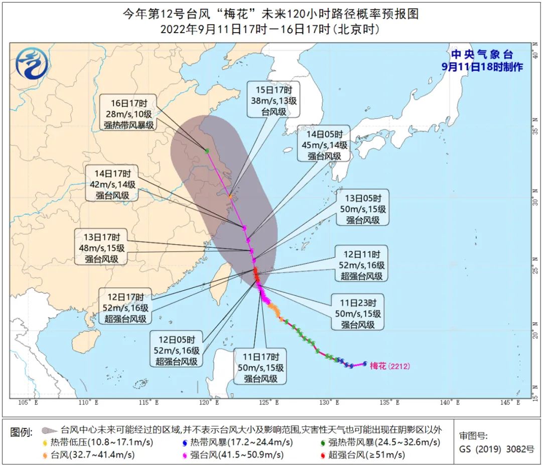
Typhoon No. 12 this year, "Plum Blossom" at 17:00 on September 11th, is located on the ocean surface of about 355 kilometers southeast of Taipei, Taiwan Province, namely 23.1 degrees north latitude, 124.3 degrees east longitude, and the largest wind near the center of the center. In seconds), the lowest air pressure in the center is 940 hundred Pache. It is expected that "plum blossoms" will slowly move north at a rate of 5-10 kilometers per hour, and the strength will not change much, the strongest can reach 50-55 meters/s class). Tomorrow night through the Ryukyu Islands and entering the southern waters of the East China Sea, they gradually approached Zhejiang coast.
Affected by it, from this evening to tomorrow, the wind of the southern sea of the East China Sea gradually strengthened from 8-10 to 10-12. Tomorrow at night, the wind of the coastal sea surface of Luqiao District gradually strengthened to level 7 gusts 8-9. Please return to Hong Kong in time to return to Hong Kong. Fighting.
Affected by the peripheral of "plum blossoms", it is expected that the rainwater will gradually increase tomorrow, the rainfall appears, and the maximum temperature will fall below 30 ° C. From the late September 14th to September 15th, the impact of wind and rain is obvious, and everyone needs to pay attention to prevention.
As the weather system is relatively complicated in the near future, the subtropical high pressure is in the adjustment period. There are western wind grooves in the north, and typhoon embryos on the east side of the "plum blossom" may form Fujiwara effect. Determination. Everyone should pay close attention to the latest forecast and early warning information released by the Meteorological Observatory of Luqiao District and do a good job of preventing the platform.
Please click to see the latest path of the typhoon
Weather forecast

According to the Meteorological Observatory of the Luqiao District, it is cloudy to overcast from this evening to the night, and local showers; there will be shower in the clouds tomorrow; there will be shower in Yin. The lowest temperature tomorrow morning: 22 to 24 degrees; the highest temperature tomorrow day: 27 to 29 degrees. The coastal sea surface: north to northeast wind 5-7 levels gradually enhanced to level 6-8.
September 12th (Monday): There are showers to cloudy to overcast, 23-28 ° C;
September 13th (Tuesday): There is a shower of Yin, 23-28 ° C;
September 14th (Wednesday): Yin is rainy, 23-27 ° C;
September 15th (Thursday): Yin is so heavy to heavy rain, 23-26 ° C;
September 16 (Friday): cloudy to overcast, local light rain, 22-31 ℃;
September 17 (Saturday): Cloudy to Yin, 22-32 ° C;
September 18 (Sunday): Cloudy, 24-32 ℃;
September 19 (Monday): Cloudy, 23-32 ℃;
September 20 (Tuesday): Cloudy turns overcast sometimes light rain, 24-32 ° C.
Currently
"Plum Blossom" has a certain distance from us
Uncertainty is relatively large
Hope "Plum Blossom" is a
The "good typhoon" that cannot be used to replenish the disaster
- END -
The Mid -Autumn Festival small holiday railway transportation is expected to send 5.56 million passengers per day
China Net September 9th (Reporter Tang Jialei) The reporter learned from China National Railway Group Co., Ltd. (hereinafter referred to as National Railway Group) that the railway Mid -Autumn Festi
Yangzhou City, Jiangsu Province, 2022 Food Safety Propaganda Week launched

On September 7, the launching ceremony of the Food Safety Publicity Week of Yangzh...