Strong typhoon level!"Plum Blossom" will affect these places
Author:Chinese anti -cult Time:2022.09.11

"Plum Blossom" strengthened into a strong typhoon level this morning
May log in or wipe the coast of Zhejiang on the 15th
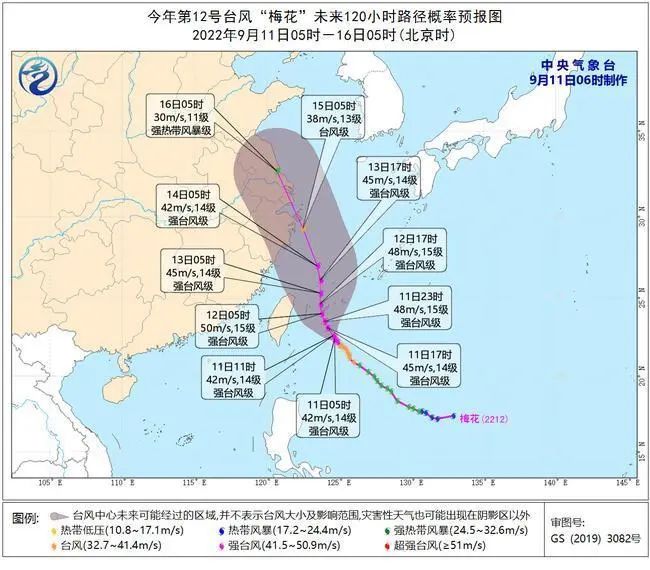
The Central Meteorological Observatory issued a typhoon blue warning at 6 o'clock on September 11: Typhoon Plum (English name: MUIFA; Source: China Macau) was generated on the Northwest Pacific Ocean on September 8th at 8 am on September 8th. This (11th) was strengthened to a strong typhoon level in the early morning. At 5 o'clock in the morning, it was located on the northwest Pacific Ocean, 440 kilometers southeast of Taipei, Taiwan Province, which was 22.4 degrees north latitude and 124.7 degrees east longitude. Grade (42 meters/s), the lowest air pressure in the center is 955 hundred Pache, the seventh-level wind ring radius is 260-300 kilometers, the 10-level wind ring radius is 70 kilometers, and the twelve-level wind ring radius is 30 kilometers.
It is expected that "plum blossoms" will move northwest at a rate of 15-20 kilometers per hour, and the intensity will gradually increase, the strongest can reach 45-50 meters/s (level 14-15, strong typhoon level). On the evening of the 12th, the intensity began to weaken slowly, and continued to move northwest. After passing through the Ryukyu Islands, entered the southern sea surface of the East China Sea. It gradually approached the coast of the eastern part of Zhejiang.
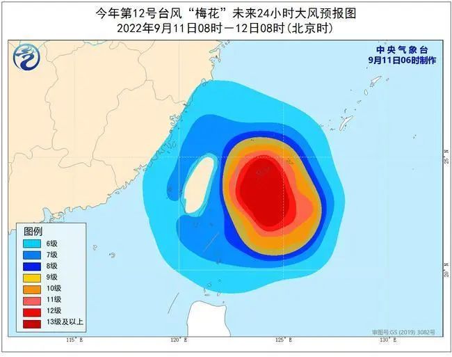
Dafeng forecast: 8:00 on September 11th to 8:00 on the 12th, the southern sea surface of the East China Sea, the Taiwan Strait, Taiwan's East Ocean, Bus Strait, the coast of Taiwan Island, and the waters near the Diaoyu Islands have 6-7 Grade Winds. ; The southeast of the East China Sea and some of the waters east of Taiwan have 8-11 gales. The wind in the nearby sea and regions passed by the "Plum Blossom" center is 12-15, and the wind can reach level 16.
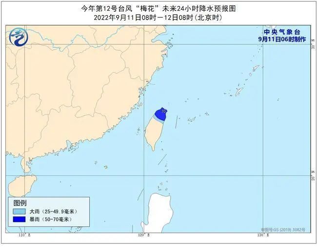
Precipitation forecast: From 8:00 on September 11th to 8:00 on 12:00, there will be middle to heavy rain in northern Taiwan and heavy rain.
Defense guide
1. Relevant departments do a good job of preventing typhoons in accordance with their responsibilities.
2. Related water operations and past ships should return to the port to avoid wind, strengthen port facilities, and prevent the ship's anchor, stranding and collision.
3. Stop outdoor dangerous operations such as large -scale rally indoor and outdoor and high altitude.
This article is reproduced from the WeChat public account "Xinhua News Agency", Source: China Weather Network
not
not
- END -
Lan Shan District Industrial and Information Bureau launches network security publicity week activities

In order to further popularize the knowledge of network security and continuously ...
[Epidemic prevention and control Gansu in action] Ningxin and aggressive resistance to the epidemic is all out to protect the supply
In the past few days, in the face of sudden epidemic, under the premise of stri...