The emergency response of the anti -typhoon anti -typhoon prevention is the level IV emergency response!"Plum Blossom" approached, the maximum wind has reached the upper limit of a strong typhoon
Author:Traffic Tourism Herald Time:2022.09.12
Source: Hangzhou Release, Hangzhou Meteorological Bureau, Central Meteorological Observatory, Zhejiang Emergency Management, China Weather
The copyright belongs to the original author, if there is any infringement, please contact it in time
This morning
Provincial defense refers to adjusting typhoon emergency response to level IV
Typhoon "Plum Blossom" latest trends?
When does it affect Hangzhou?
Let's see the latest news together!
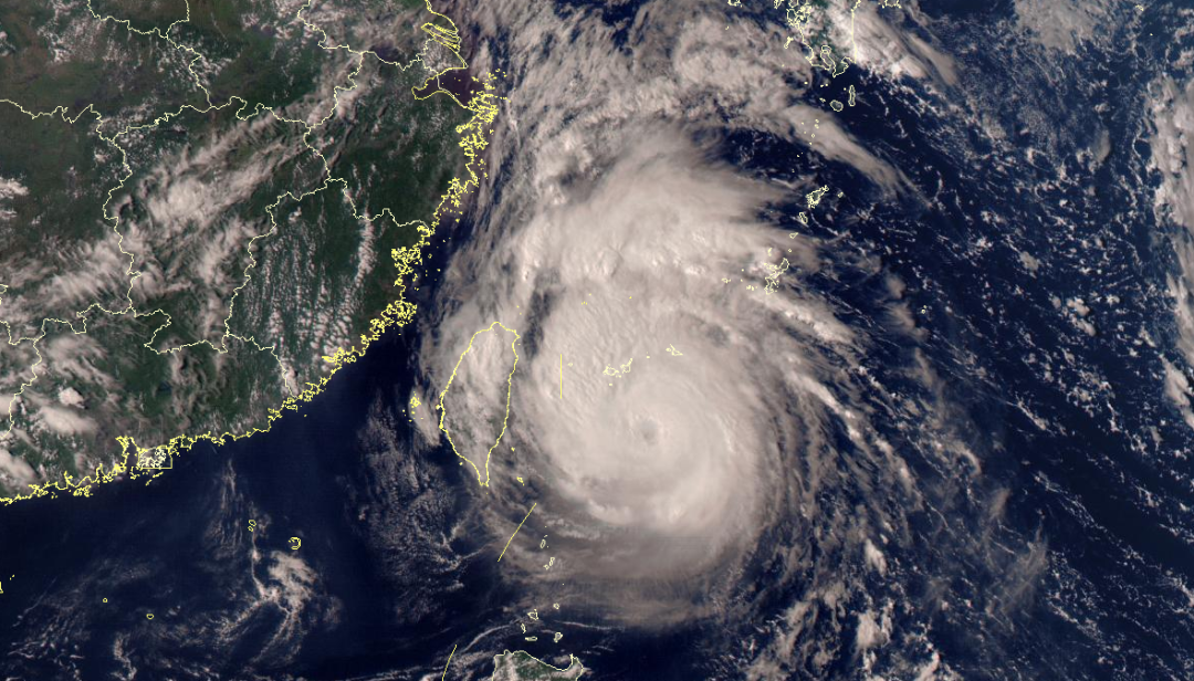
September 11th at 15:00 Fengyun No. 4 Satellite True Color Synthetic Map Source: National Satellite Meteorological Center
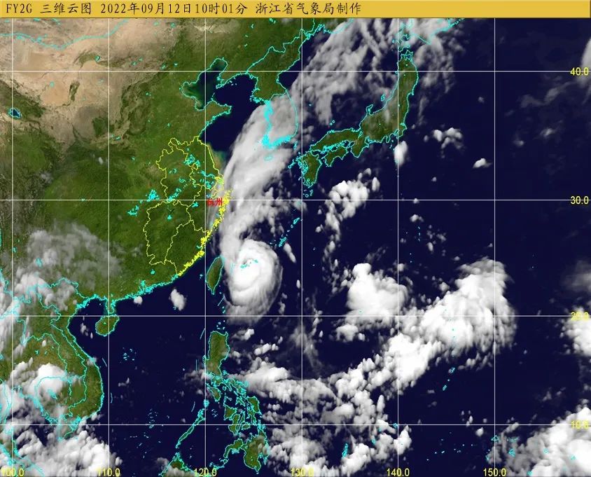
Typhoon "Plum Blossom" No. 12 this year is located on the ocean surface of about 310 kilometers south of Taipei, Taiwan Province at 5 o'clock today. The speed of 5-10 kilometers moves north to the west, and its strength is slowly weakened. It will enter the southern sea of the East China Sea after passing through the Ryukyu Islands on the night of the 12th, and gradually approach the northern coast of our province.
According to the "Zhejiang Province Flood Control and Drought Resistance Emergency Plan", the provincial defense index was decided to adjust the typhoon prevention response to the IV emergency response at 9:00 on September 12. All localities and departments are requested to pay close attention to the trend of typhoons and further do a good job of typhoon "plum blossoms" to defense.
The Central Meteorological Observatory continued to issue a typhoon blue warning today
The Central Meteorological Observatory continued to issue a typhoon blue warning at 10:00 on September 12:
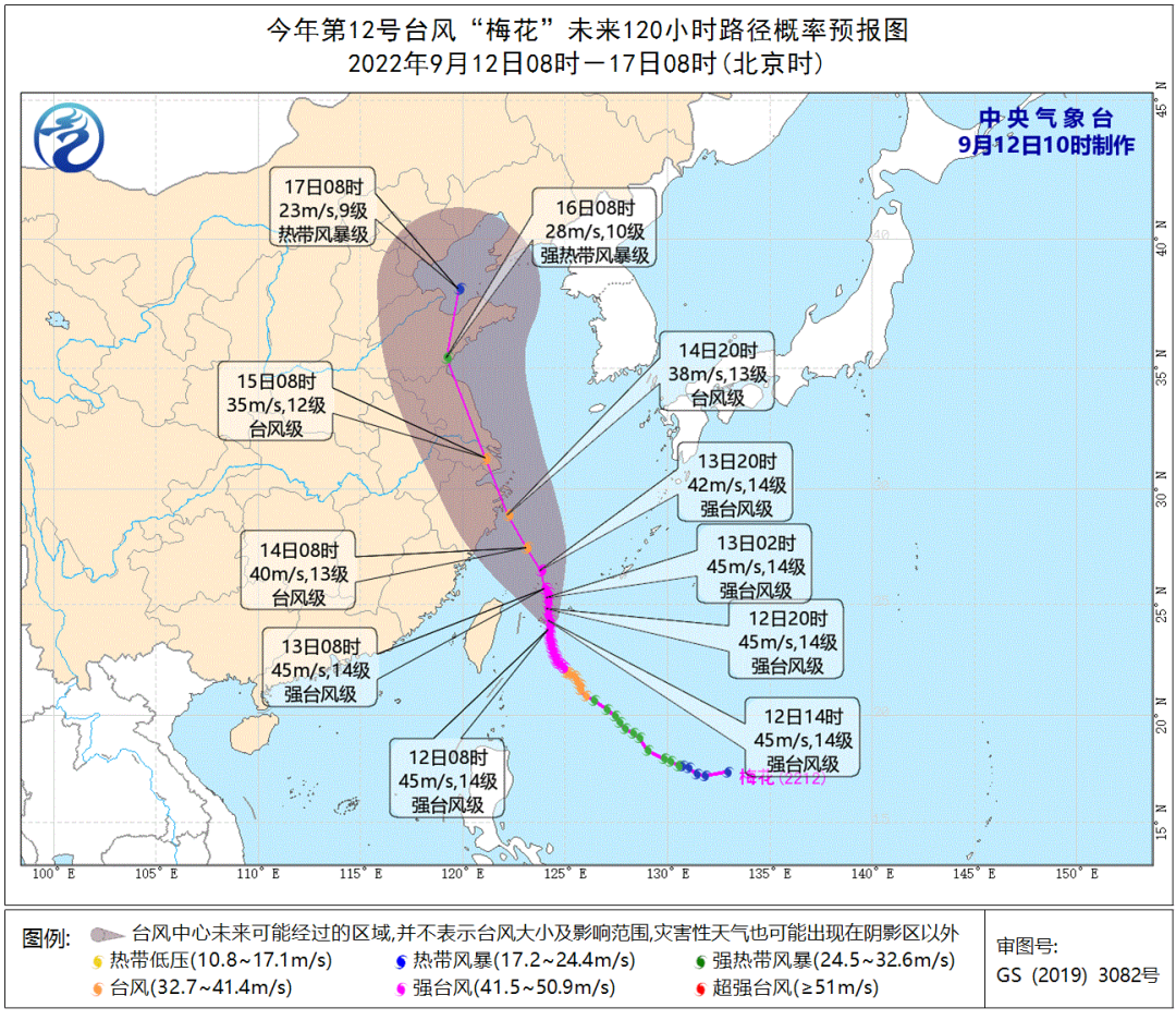
Typhoon No. 12 this year's "Plum Blossom" (strong typhoon level) is located on the east of Taiwan, about 680 kilometers east of Zhoushan City, Zhejiang Province today (12th) at 9 am today (12th). Degree, the maximum wind near the center is 14 levels (45 meters/s), the lowest air pressure in the center is 950 hundred Pache, the seventh-level wind ring radius is 220-260 kilometers, the 10-level wind ring radius is 60 kilometers, and the 12-level wind ring radius is 30 kilometers. Essence
It is expected that "plum blossoms" will move north to west at a speed of 5-10 kilometers per hour, and the strength will be weakened slowly. It will move through the Ryukyu Islands on the evening of the 12th to the south of the East China Sea. From the night of the 14th to the 15th, he landed or wiped the above coastal areas during the day.
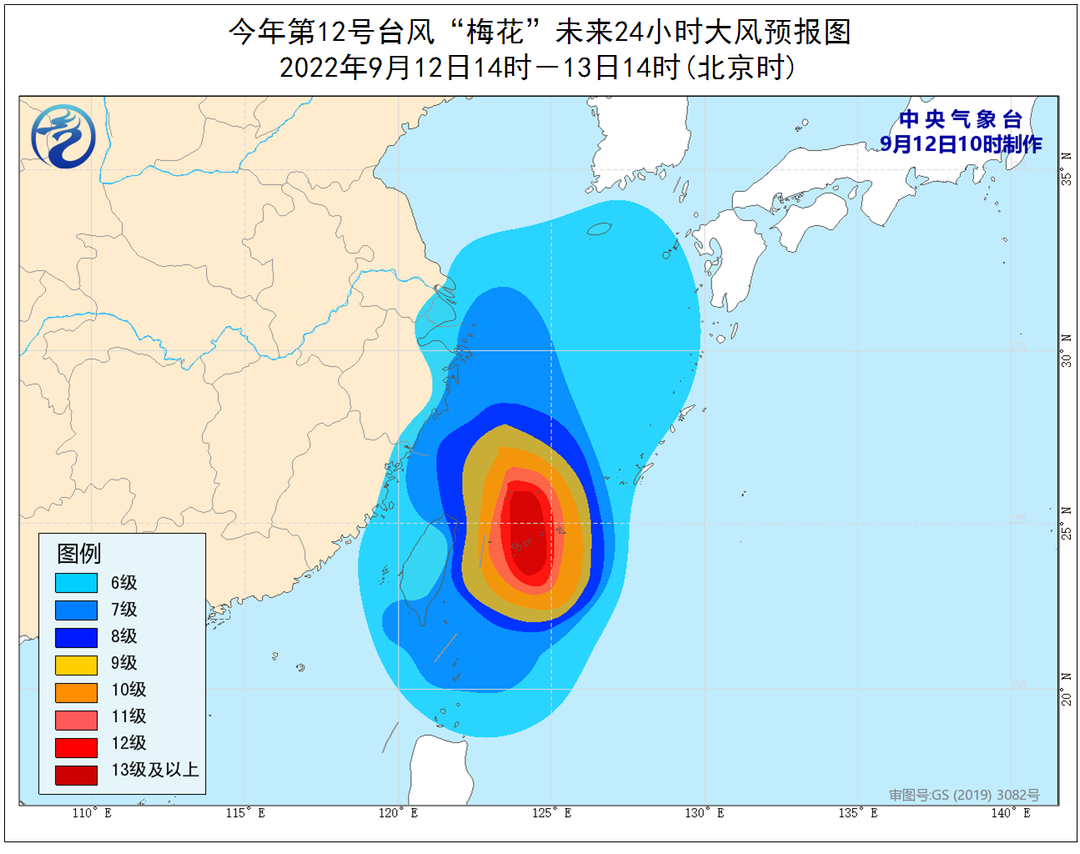
Dafeng forecast: From 14:00 on September 12th to 14:00 on the 13th, the southern waters of the Yellow Sea, most of the East China Sea, Taiwan Strait, Taiwan Strait, Bus Strait, Coastal of Taiwan Province, Sea near the Diaoyu Islands, Hangzhou Bay, Zhejiang Coast, Fujian Coastal Coastal The coast of Shanghai and the southeast coast of Jiangsu has 6-7 garage, and gusts are 8-9; the southern seas of the East China Sea and some waters east of Taiwan have 8-11 large winds. With level 12-14, gusts can reach level 15-16.
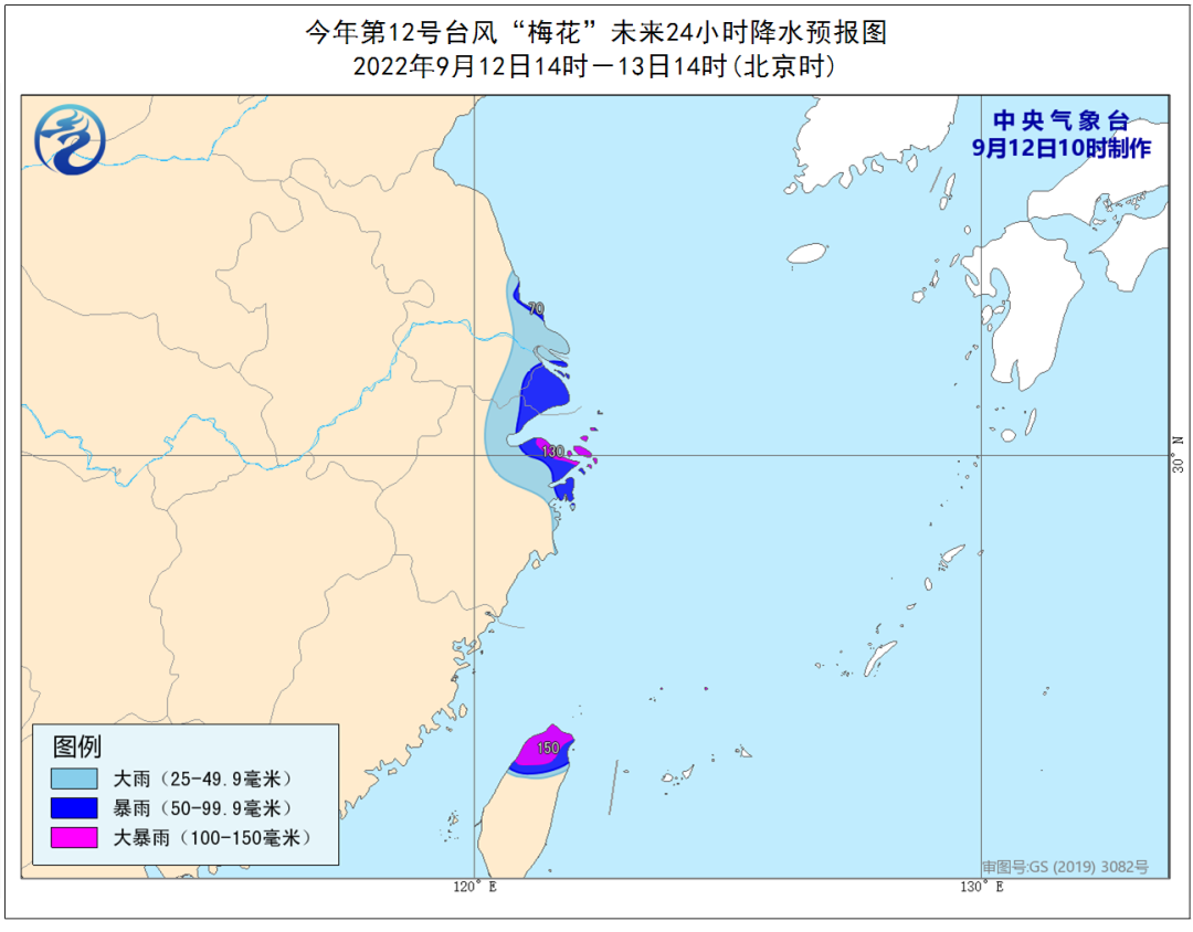
Precipitation forecast: From 14:00 on September 12th to 14:00 on the 13th, there were heavy rains in southeast Jiangsu, Shanghai, northeast of Zhejiang, northern Taiwan Island, and heavy rain in some areas (100-150 mm).
Defense guide:
1. Government and relevant departments do a good job of preventing typhoon rescue emergency in accordance with their duties.
2. Related water operations and past ships should return to the port to avoid wind, strengthen port facilities, and prevent the ship's anchor, stranding and collision.
3. Stop outdoor dangerous operations such as large -scale rally indoor and outdoor and high altitude.
Affected by typhoon "plum blossoms", the weather changes after the Hangzhou Festival
During the Mid -Autumn Festival holiday, Hangzhou was accompanied by good weather, but the holidays returned and the weather pattern changed greatly. We will accept the test of typhoon "plum blossoms".
Affected by the circulation of the periphery of the typhoon "Plum Blossom", it is expected that from the mountains of the eastern districts and counties and the northwestern mountainous areas of the eastern district and the northwestern mountainous area of the eastern district and the northwestern mountainous area of the northwest of Yuhang. Heavy rain to heavy rain and local heavy rain; the wind has gradually increased from the 13th. On the morning of 14-15, there are 7-9 levels of wind, and some high levels of high mountainous areas and Qiantang River levels are 9 to 10 levels.
Focus on
1. On the 14-15, there are heavy rain to heavy rains in the mountains and counties in the northern part of Lin'an, local heavy rain, northwind, 7-9 levels, and some high mountains and Qiantang Rivers and other rivers and lakes. The adverse effects of disaster weather such as rainfall and wind.
2. Due to the complexity of the atmospheric circulation, the subtropical high pressure and cold air affect the interweaving, Typhoon No. 13 "Miao Bai" has been generated at 8 o'clock today. Big, we will pay close attention to the post -movement trends of typhoons.
What are the main aspects of typhoon hazards?
How should we defend typhoons?
You have to know these things!
- END -
Opening the park in August!Baoqing will add a theme park

Our Ferris wheel height reaches 49.5 meters, which can meet 180 people at the same...
Beijing catering company welcomes "Ganlin" 100 million yuan catering consumer coupon is about to arrive
According to the Beijing Municipal Bureau of Commerce on July 17, in order to accelerate the recovery of catering consumption in the city, according to the overall arrangement of the Beijing Consumpti