"Plum Blossoms" will arrive in advance than expected, which will have a serious impact on Zhejiang.
Author:Published by Zhejiang Time:2022.09.12
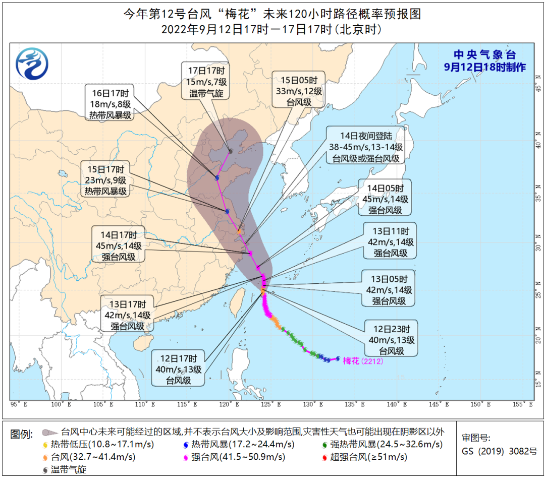
Typhoon "Plum Blossom" is getting closer and closer to the East China Sea, and the typhoon movement speed has also accelerated. It is expected that "plum blossoms" will enter the East China Sea today and will arrive earlier than expected.
The maximum is likely to land on the night of the 14th to 15th or wipe over Zhoushan to the coast of Ningbo. The Provincial Meteorological Observatory has issued a typhoon alert on the 12th.
Typhoon
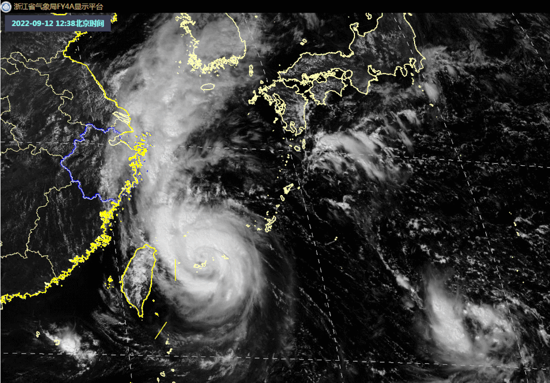
At 19:00 this afternoon, the typhoon "Plum Blossom" was located at 24.8 degrees north latitude and 124.0 degrees east longitude. It was about 600 kilometers east of the south of Zhoushan City, Zhejiang Province. It is expected that "plum blossoms" will slowly move north at a speed of 5-10 kilometers per hour, and the intensity will be strengthened.
As the typhoon "plum blossoms" approached step by step, the impact on Zhejiang waters gradually increased.
According to the "Zhejiang Province Flood Control and Drought Resistance Emergency Plan", the provincial defense index was decided to raise the typhoon prevention response to level III at 17:00 on September 12, and to do a good job of typhoon defense.
At 11:00 on September 12, the Zhejiang Provincial Meteorological Bureau raised the typhoon emergency response to the third level.
At 17:30 on September 12, the Provincial Water Resources Department raised the emergency response of the water and drought disaster defense (anti -Taiwan) to the level III.
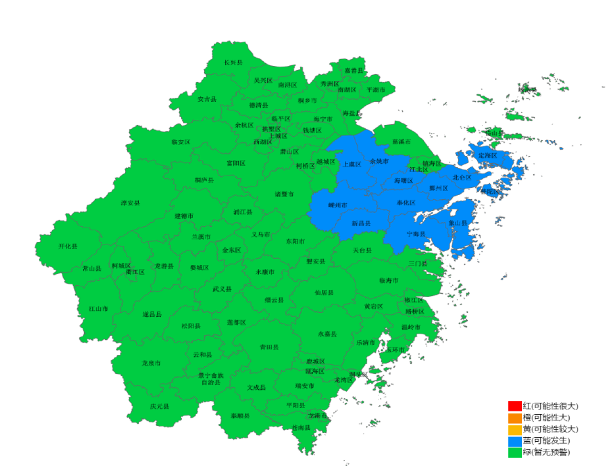
At 17:11 on September 12th, the Provincial Department of Water Resources and the Provincial Infaculture Bureau jointly issued the blue warning of the mountain flood disaster: It is expected to be at 20:00 on the 12th to 20:00 on the 13th, Haishu District, Beilun District, Puzhou District, Fenghua District, Xiangshan County, Ninghai County, Yuyao City, Shangyu District, Xinchang County, Puzhou City, Dinghai District, and Putuo District may occur (blue warning). Please pay close attention to the changes in the weather situation and rainwater, and pay attention to preventing mountain flood disasters caused by heavy precipitation.
According to the "Ningbo City Flood Control and Drought Resistance Emergency Plan", Ningbo's defense index decided to increase the emergency response to typhoon prevention to level III on September 12.
At 16 pm on the 12th, the Zhejiang Provincial Marine Monitoring and Forecast Center launched the storm wave blue alert, and the yellow alarm continued to be maintained.
The Zhejiang Marine Monitoring and Forecast Center issued storms and blue alerts and wave yellow alerts in accordance with the "Emergency Plan for Marine Disasters".
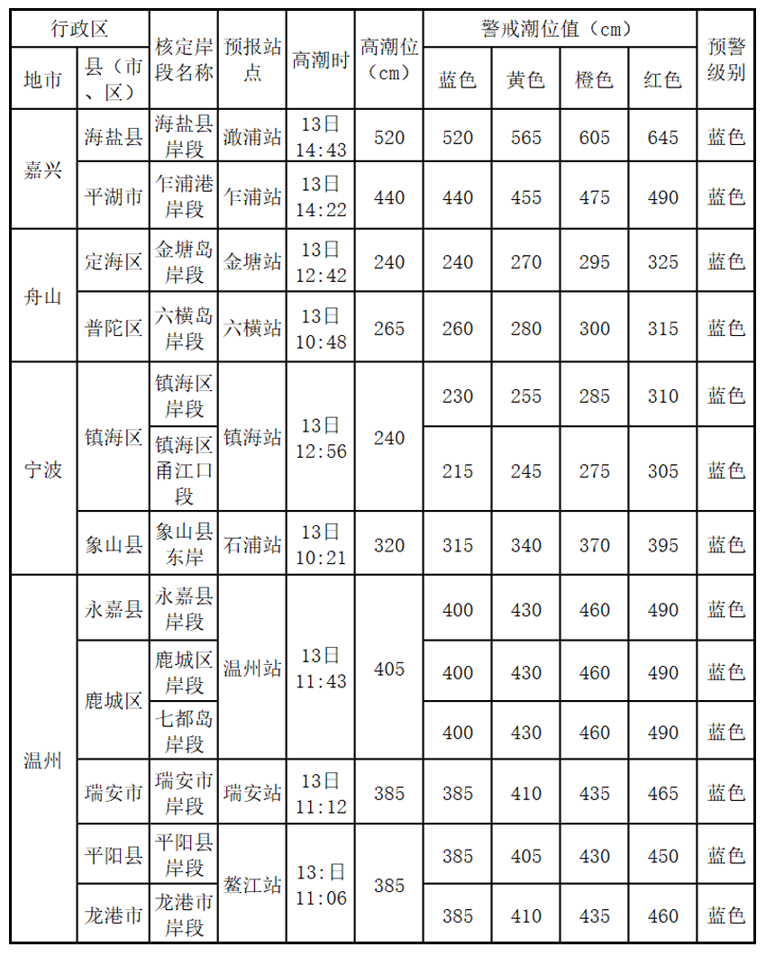
Affected by Typhoon No. 12 "Plum Blossom" (Typhoon Grade), it is expected to increase the water of 30-60 cm along the coast of Jiaxing, Zhoushan, and Ningbo. Increase water. Xupu, Shibura, Jinsang, Liuheng, Zhenhai, Shipu, Wenzhou, Ruian, and Aojiang Station will appear more than the climax of the local blue warning tide. Storm wave warning level is blue.
The specific forecast value is as follows:

Storm wave alert map
Affected by Typhoon No. 12 "Plum Blossom" (Typhoon Grade), it is expected to be from this night to tomorrow during the day:
Near -sea waters: Hangzhou Bay has a light to Zhonglang from 0.8 meters to 1.4 meters, and will increase to 1.4 meters to 2.2 meters of medium waves tomorrow evening; there will be 2.0 meters to 3.0 meters in the northern part of Zhejiang. Mi to 5.0 meters is large to huge waves; there are large to large waves from 3.0 meters to 4.0 meters in central Zhejiang, and will increase from 5.0 to 6.5 meters from a giant wave from 5.0 meters to 6.5 meters tomorrow evening; By the giant waves, it will increase from 6.0 to 7.5 meters tomorrow evening. The warning level of the sea waves in the sea is yellow.
Near -shore waters: Zhoushan has 1.2 meters to 2.0 meters of light to Zhonglang, and tomorrow evening will increase to large waves from 2.5 meters to 3.4 meters. The big waves of rice; Taizhou has a mid -to -large wave from 1.6 meters to 2.5 meters, and will increase to large waves from 2.8 meters to 3.6 meters tomorrow evening. The big wave of rice. Near -shore sea wave warning level is yellow.

Wave Police News
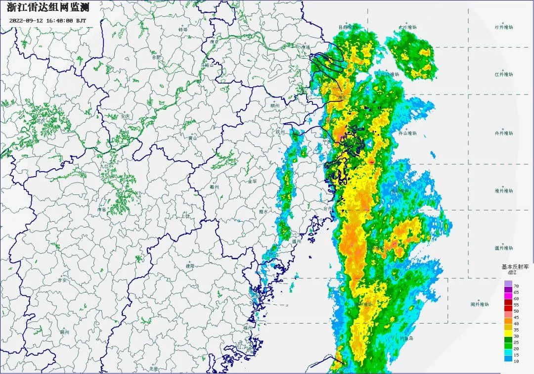
Typhoon "Plum Blossom" weather impact
The typhoon has not arrived, the wind and rain are first, and due to the influence of the "plum blossoms" peripheral circulation. At present, the precipitation of Zhoushan, Ningbo and other places is particularly obvious.
Georgian forecast
From this afternoon to 15th, the wind of the East China Sea has gradually increased from the south to the 12-14 levels.
From this afternoon to tomorrow (13th), the coastal seas gusts of the coast of Zhejiang are 8-9th. From the afternoon of the 13th, the coastal surface of Zhejiang and South Zhejiang has increased to level 10-12. Above the level.
Precipitation forecast
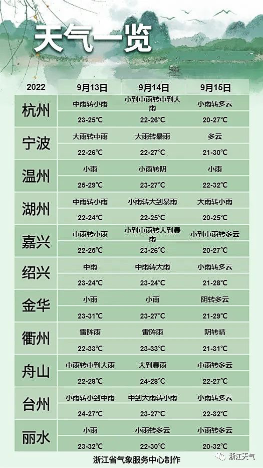
Affected by "plum blossoms", there were heavy rainstorms in the central and eastern Zhejiang and northern Zhejiang regions on 12-15. The cumulative rainfall generally had 80-150 mm. ~ 300 mm, individual 500 mm or more.
Tonight
There are medium rain in the eastern region of central Zhejiang, and the eastern part of Ningbo, Zhoushan, Jiaxing, and Shaoxing is as heavy as heavy rains.
September 13th
There are heavy rains in the northern part of Zhejiang, and some heavy rain in Ningbo, Zhoushan, Shaoxing, eastern Taizhou, southern Jiaxing, and other heavy rain;
September 14th
There are heavy rainstorms in northern Zhejiang and eastern Zhejiang regions. There are heavy rain in Ningbo, Shaoxing, Jiaxing, Zhoushan, and northern Taizhou.
September 15th
Part of the northern part of Zhejiang to heavy rain, local heavy rain.
Weather forecast for the next three days
Bleak
Focus
Bleak
"Plum Blossoms" may be a typhoon when it is close to the coast of Zhejiang. Whether it is landing in Zhejiang or tightly wiping off the sea, it will have a serious impact on Zhejiang.The wind of the East China Sea and the coast of Zhejiang lasts for a long time. Past vessels should be transferred to a safe area to avoid wind in time to do a good job of safety management of maritime operations and sea -related tourism.
"Plum Blossoms" will be combined with cold air. The total rainfall in the eastern part of Zhejiang is large. The heavy rainfall and "Xuan Lannuo" have a strong rainfall, and the risk of secondary disasters such as floods, mudslides, and urban and rural floods occur.
At present, the situation of the atmospheric circulation is complicated, and there are many low pressure on the land and Shanghai, which may have mutual influence, and there is uncertainty in the later paths.
The content is based on the Central Meteorological Observatory, Zhejiang Weather, Zhejiang Emergency Management, Zhejiang Water Conservancy, Provincial Marine Monitoring and Forecast Center, Ningbo Release, etc.
Xue Editor: Ji Qunya
Editor in charge: Dong Youyou
- END -
A study of Chinese scientists is expected to make artificial intelligence more "understand" humans
A study led by Chinese scientists has made breakthroughs in allowing artificial intelligence to quickly identify human value intentions, and can improve the efficiency of human -machine collaboration
The dried river bed in the small waves of the Huanghe River in Luoyang presents a beautiful picture

With the end of the water conservancy hub before the flood of the Yellow River, th...