The China Meteorological Administration starts a third -level emergency response, the typhoon "plum blossom" may land in East China
Author:Changjiang Daily Time:2022.09.12
September 12
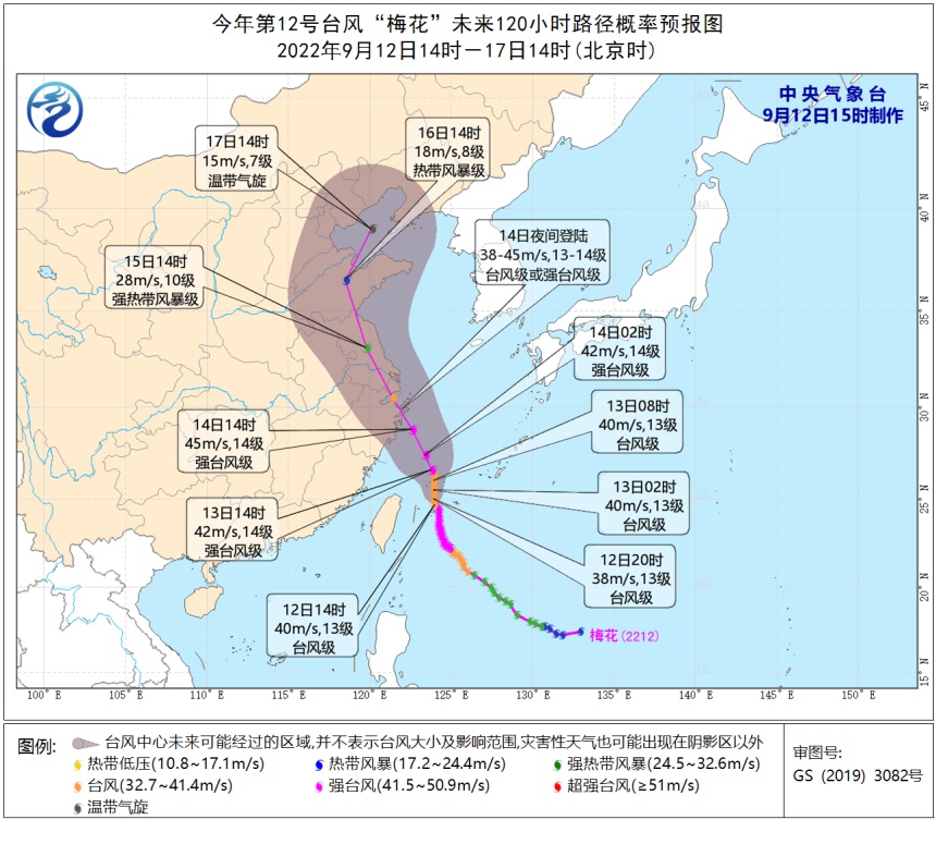
Typhoon "Plum Blossom" No. 12 this year goes north
China Meteorological Administration launched a third -level emergency response
The Central Meteorological Observatory continues to issue a typhoon warning
It is expected that "plum blossoms" will be on the night of the 12th to the early morning of the 13th
After passing through the Ryukyu Islands, enter the south of the East China Sea
Gradually approaching the coast of northeast Zhejiang
It may be on the night of the 14th to the 15th day of the day
Log in to the above coastal areas
It may also be on the north of East China
↓↓↓
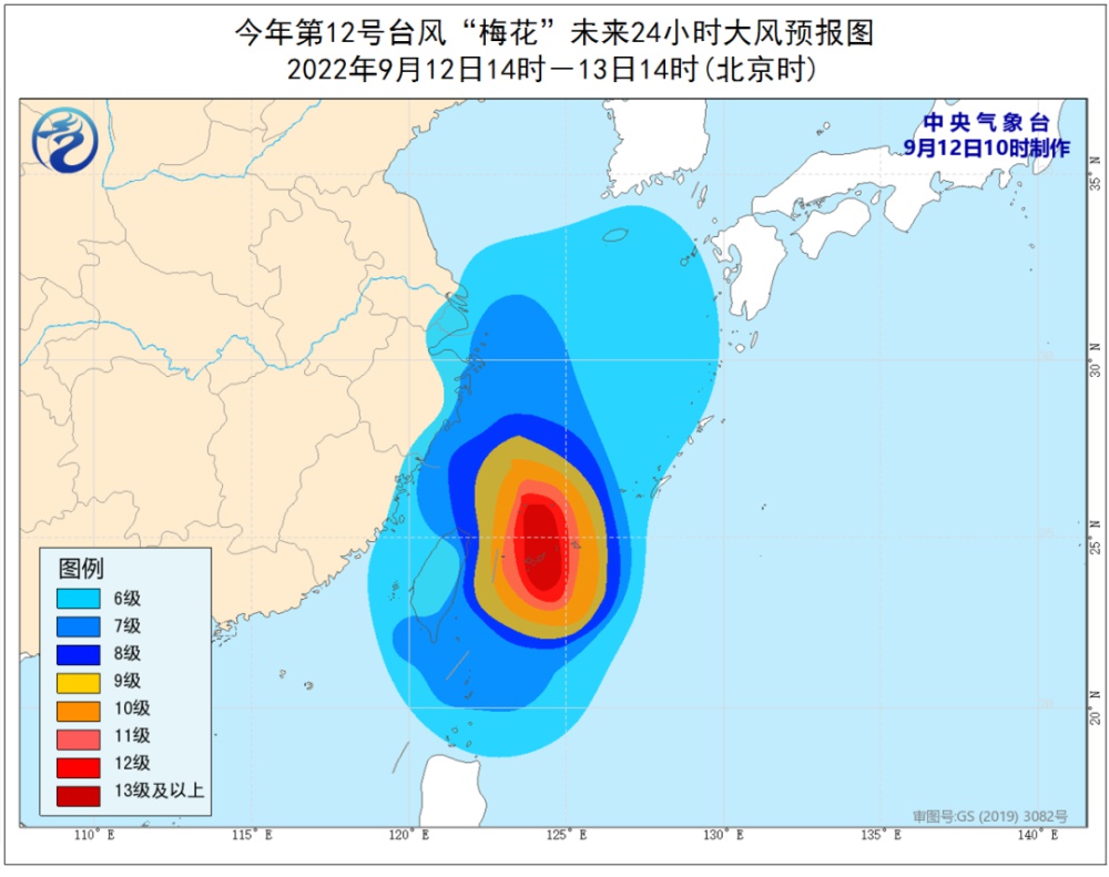
In terms of strong wind: Affected by "plum blossoms", from 14:00 on September 12th to 14:00, the southern waters of the Yellow Sea, most of the East China Sea, Taiwan Straits, Taiwan Straits, Basilica Straits, Taiwan Provinces coast, the waters near the Diaoyu Islands, Hangzhou, Hangzhou, Hangzhou Bay, Zhejiang coast, Fujian coast, Shanghai coast, and southeast of Jiangsu have 6-7 garage, gusts 8-9 levels; the southern seas of the East China Sea and some waters east of Taiwan have 8-11 large winds. There are 12-14 levels of wind and regions nearby, and gusts can reach level 15-16.
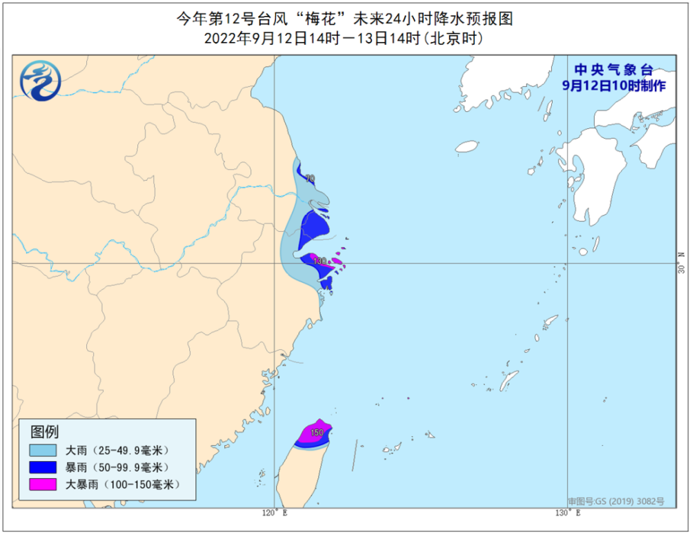
In terms of precipitation: From 14:00 on September 12th to 14:00 on the 13th, there were heavy rains in southeast Jiangsu, Shanghai, northeast of Zhejiang, northern Taiwan Island, and heavy rain in some areas (100-150 mm).
Xu Yinglong, chief forecast at the Central Meteorological Observatory: At present, the "plum blossom" affects the system complex, and there is still greater uncertainty in the movement path and later movement speed. class. "Plum Blossoms" may become the first typhoon to land on the coast of East China this year.
Although the intensity of "plum blossoms" is less than Typhoon Xuan Lannuo No. 11 this year, because it is closer to the coastal coastal of Zhejiang, Shanghai and Jiangsu, the impact of typhoon "plum blossoms" will be greater than "Xuanlan Lan Lan promise".

Expert tips
As the typhoon path continues to adjust the west, the possibility of "plum blossoms" on my country is increasing, and the impact of wind and rain has begun to reveal. Port -avoiding wind, strengthening port facilities, preventing ships from anchoring, stranding and collision; stopping outdoor dangerous operations such as large -scale rally and high -altitude indoor and outdoor; public attention to typhoon forecasting early warning information in a timely manner, and preventive measures in advance.
at last
Send it for everyone
Typhoon Defense Guide
What is a typhoon landing point?
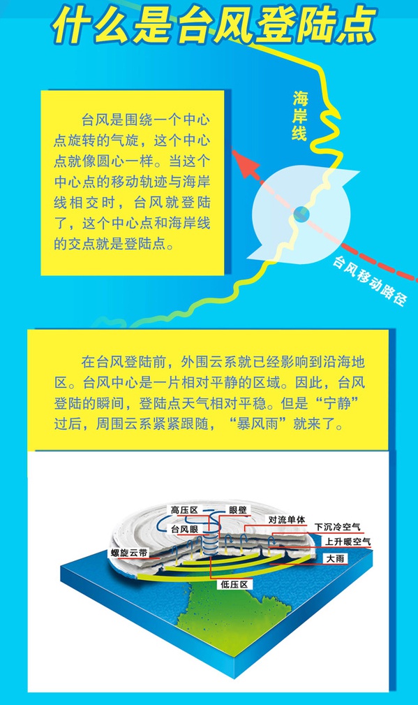
Typhoon landing point
Will it be the worst disaster?

How to avoid the typhoon?

(Author: China Meteorological Daily All -Media reporter Wu Hui)
(Source: Xinhua News Agency)
【Edit: Yao Hao】
For more exciting content, please download the "Da Wuhan" client in the major application markets.
- END -
People in Shenzhen do not stock up!The city's vegetables, meat, rice noodles and oils and oils are "sufficient and stable"
Recently, the situation of the prevention and control of Shenzhen's epidemic situa...
Changle Wutu Street In -depth Enterprises Carry out safety inspections

In order to further promote the three major campaigns of safety production and do ...