Comprehensive upgrade!"Mei Chaofeng" attacked Zhejiang!Hangzhou ushered in a heavy rainstorm!The emergency response of Typhoon Anti -Typhoon in Zhejiang rose to level II ...
Author:Daily Business Daily Time:2022.09.13

"Plum Blossom" strengthened to be a strong typhoon level at 5 o'clock today
It is expected to land in Zhejiang on the 14th
"Plum Blossom" has opened the sprinkler mode
It is not simple to be called "Mei Chaofeng" by netizens
Tonight, everyone will continue to pay attention to safety

The Central Meteorological Observatory continued to issue a typhoon orange warning at 10:00 today (September 13). The Zhejiang Meteorological Observatory issued a typhoon alert at 10:00 today. According to the "Zhejiang Province Flood Control and Drought Resistance Emergency Plan", the provincial defense index was decided to increase the emergency response of typhoon prevention to level II at 10:00 on September 13.
Just now, Hangzhou Meteorological Observatory issued a typhoon alert!
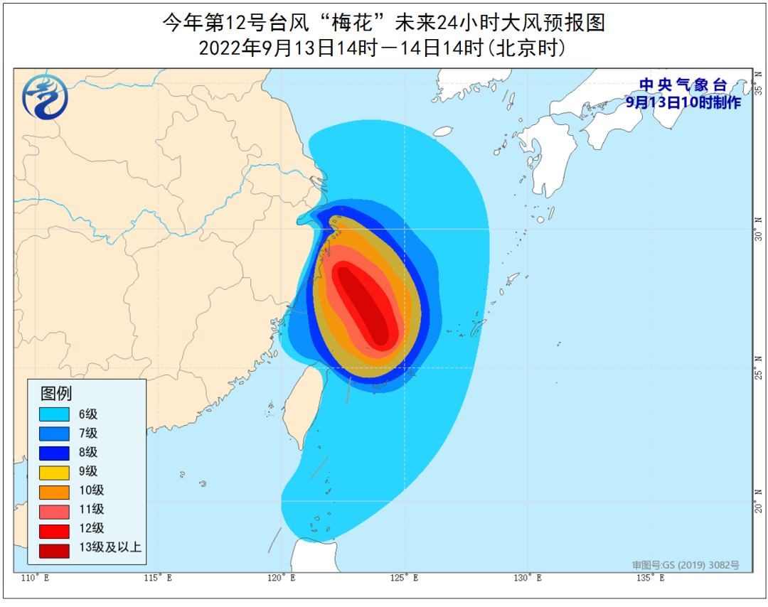
Typhoon "Plum Blossom" (strong typhoon "(strong typhoon) this year is located on the sea about 610 kilometers from the southeast of Hangzhou today (13th). The direction moves, the intensity is maintained or slightly strengthened, and it gradually approaches the coast of the central and northern part of our province. The maximum is likely to land on the coast of the three doors from the afternoon of the 14th to the night. Level 13 ~ 14).

After landing, the "Plum Blossom" will continue to move northwest, and its strength will gradually weaken.
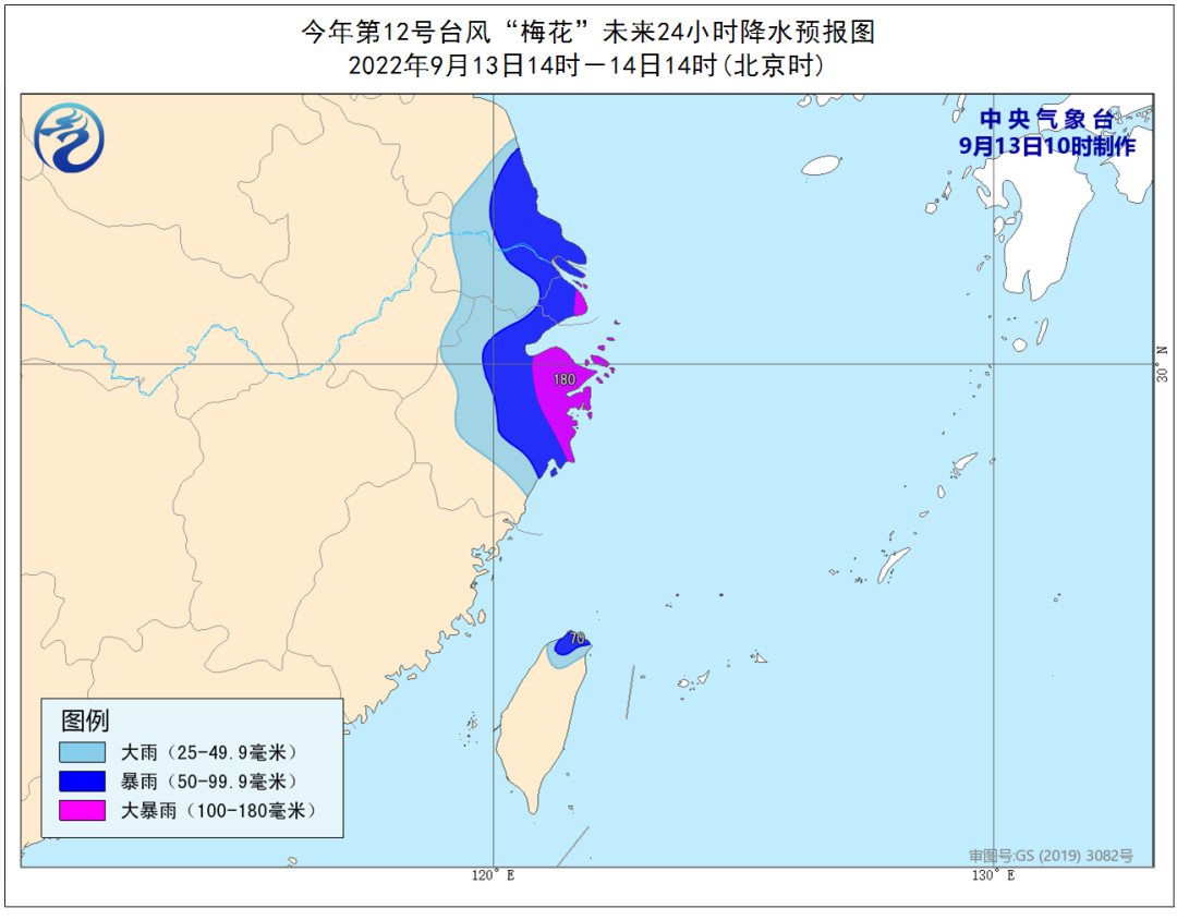
Hangzhou has a heavy rainstorm in the heavy rain
Affected by "plum blossoms", Hangzhou's rainfall was obvious. Today, there are showers in the mountains in eastern Hangzhou and Lin'an and Yuhang, and there are heavy rainstorms in the rain. There are sometimes shower in other areas. There are heavy rain to heavy rain in the mountains of eastern Hangzhou and northern Lin'an on the morning of the 15th. There is a middle shower in the yin, and the local heavy rains to heavy rain. On the afternoon of the 15th, the shower turned overcast, and it was cloudy at night.
The wind will also continue to increase. Today, the Northeast Wind Grade 4 to 5 gusts and 6 gusts 6, some high mountainous areas and Qiantang Rivers and other rivers and lakes levels 5-6 gusts 7-8 levels. From the morning of the 14th to 15th, the largest northern wind 7-9 levels, some high mountain areas and Qiantang areas River and other rivers and lakes are ranging from 9 to 10 levels.
Focus on key points and risk prompts
1. Today to 15th, strong precipitation mainly appears in eastern Hangzhou, especially Qiantang, Xiaoshan, Eastern Fuyang, and Tianmu Mountain (northern Lin'an and northwestern Yuhang). Floods in small and medium rivers, sub -floods, mudslides, landslides, and landslides.
From the morning of the 114th to 15th, the wind must prevent the wind of the wind in construction sites, temporary sheds, outdoor billboards and garden greening.
3. During the current tide of astronomy, the coast of Qiantang River needs to prevent the secondary disaster caused by strong winds, storm trends and strong rainfall, and do a good job of management of tide watching personnel.
In addition to "plum blossoms", do you still remember another typhoon -Typhoon Miao Bai, No. 13 this year? Does it affect us in the future?
The center of the "Miao Bai" (strong tropical storm) today (September 13) is located on the northwestern Pacific Ocean at about 2270 kilometers north of Guam to east of Guam, USA, 23.9 degrees north latitude, 163.3 degrees east longitude, 10 Level (28 meters/second), 982 hundred Pache, 7-level wind ring radius 220-350 kilometers, and the 10-level wind ring radius is 50 kilometers.
It is expected that "Miao Bai" will move north to northeast at a speed of 15-20 kilometers per hour, and the intensity will gradually strengthen. In the future, "Miao Bai" has no impact on my country.
Due to the complexity of the atmospheric circulation, there are currently many low -pressure systems in Lu and Shanghai, which may have mutual influence, and there is still certain uncertainty in the later paths. The meteorological department will continue to monitor and analyze closely, and please continue to pay attention.
Zhejiang released a red warning of the waves

According to the Zhejiang Provincial Marine Monitoring and Forecast Center, affected by the typhoon "plum blossom" (strong typhoon level), it is expected to be at noon today to noon tomorrow:
Near the sea: Hangzhou Bay is from 1.2 meters to 2.0 meters of light to Zhonglang, and tomorrow morning will increase to large waves from 2.5 meters to 3.5 meters; in northern, central, and southern Zhejiang, there will be 3.5 meters to 5.0 meters. Increased to 6.0 meters to 9.0 meters of mad waves. The warning level of the sea waves in the sea is orange.
Near -shore waters: Jiaxing is 1.2 meters to 1.8 meters of light to Zhonglang, and tomorrow morning will increase to 1.5 meters to 2.5 meters in the middle to large waves; Zhoushan has 2.0 meters to 3.0 meters of large waves, and tomorrow morning will increase to 3.5 to 3.5 tomorrow morning to 3.5 Mi to 5.0 meters large to huge waves; Ningbo and Taizhou have large waves from 2.5 meters to 3.5 meters, and will increase from 4.0 meters to 6.0 meters tomorrow morning; Wenzhou has a large wave from 2.5 meters to 3.5 meters. Increased to a large wave from 3.5 meters to 5.0 meters. Near -shore sea wave warning levels are red.


Part of the official website of the Central Meteorological Channel, Zhejiang Weather Weibo, Hangzhou Weather Weibo
- END -
Life is too bitter, you have to be with sweet people

Poster | Qing Ke |Master Dharma:Life is too bitter, you have to be with sweet people...
National -level publicity, Quanzhou is on the list

The fireworks of the night market are the most caressing. Recently, the Ministry o...