Notice!"Plum Blossom" strengthened into a strong typhoon this morning
Author:Kuiwen Published Time:2022.09.13
The Central Meteorological ORC issued a typhoon orange warning at 06:00 on September 13:
Typhoon "Plum Blossom" No. 12 this year has moved into the south of the East China Sea in the early morning of today (13th), and strengthened to a strong typhoon level at 5:00. It is 25.5 degrees north latitude and 124.1 degrees east longitude. The maximum wind near the center is 14 levels (42 meters/s), the lowest air pressure in the center is 955 hundred Pache, the seven-level wind ring radius is 220-260 kilometers, and the 10th wind ring radius is 60 kilometers. The secondary wind ring radius is 30 kilometers.
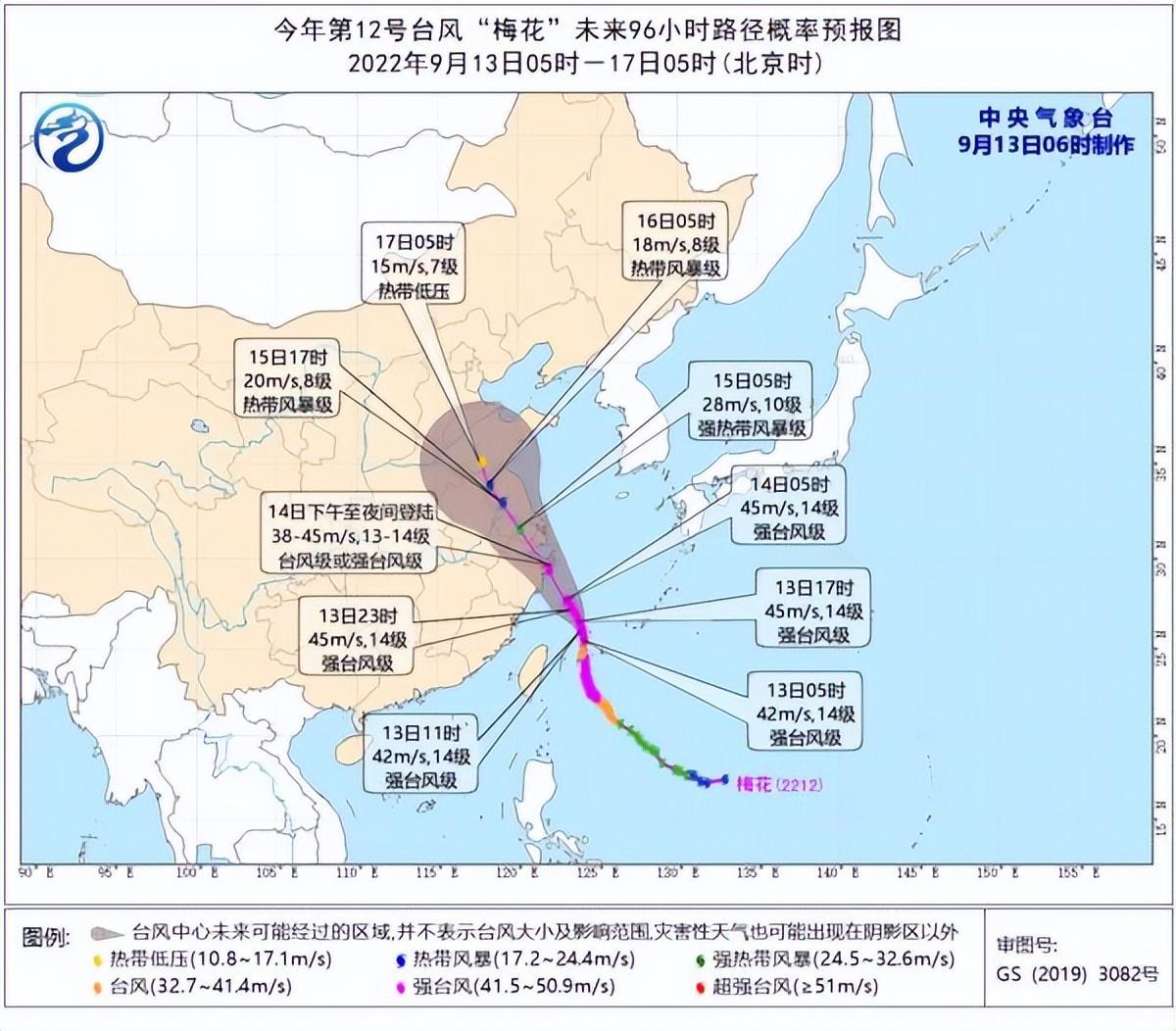
It is expected that "plum blossoms" will move north to northwest at a speed of 10-15 kilometers per hour, and the intensity will be strengthened. It will gradually approach the coast from Wenling, Zhejiang to Zhoushan. Login along the coastal area (typhoon or strong typhoon level, 38-45 meters/s, level 13-14); after landing, "plum blossoms" will continue to move northwest, and the intensity will gradually weaken.
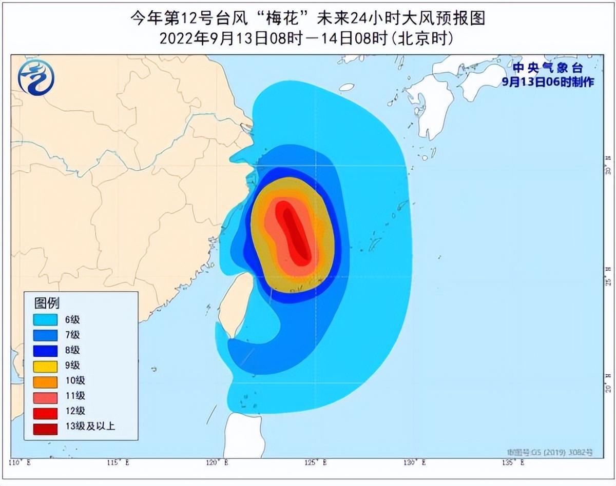
Great Wind Forecast:
From 8:00 on September 13th to 8:00 on the 14th, the bus Strait, the northern part of the Taiwan Strait, the southwest of the Yellow Sea, the waters of the Yellow Sea, most of the waters near the Diaoyu Islands, the Yangtze River Estuary Area, Hangzhou Bay and the northern part of Taiwan and the coast of the east and the eastern coastal coastal areas , Zhejiang coast, the northern coast of Fujian, the coast of Shanghai, and the southeast coast of Jiangsu will have 6-8 strong winds, and the gusts are 9-11. Among them, there will be 9-11 gale in some waters of the East China Sea. The wind on the nearby sea across the center is 12-14, and the gusts can reach level 15-16.
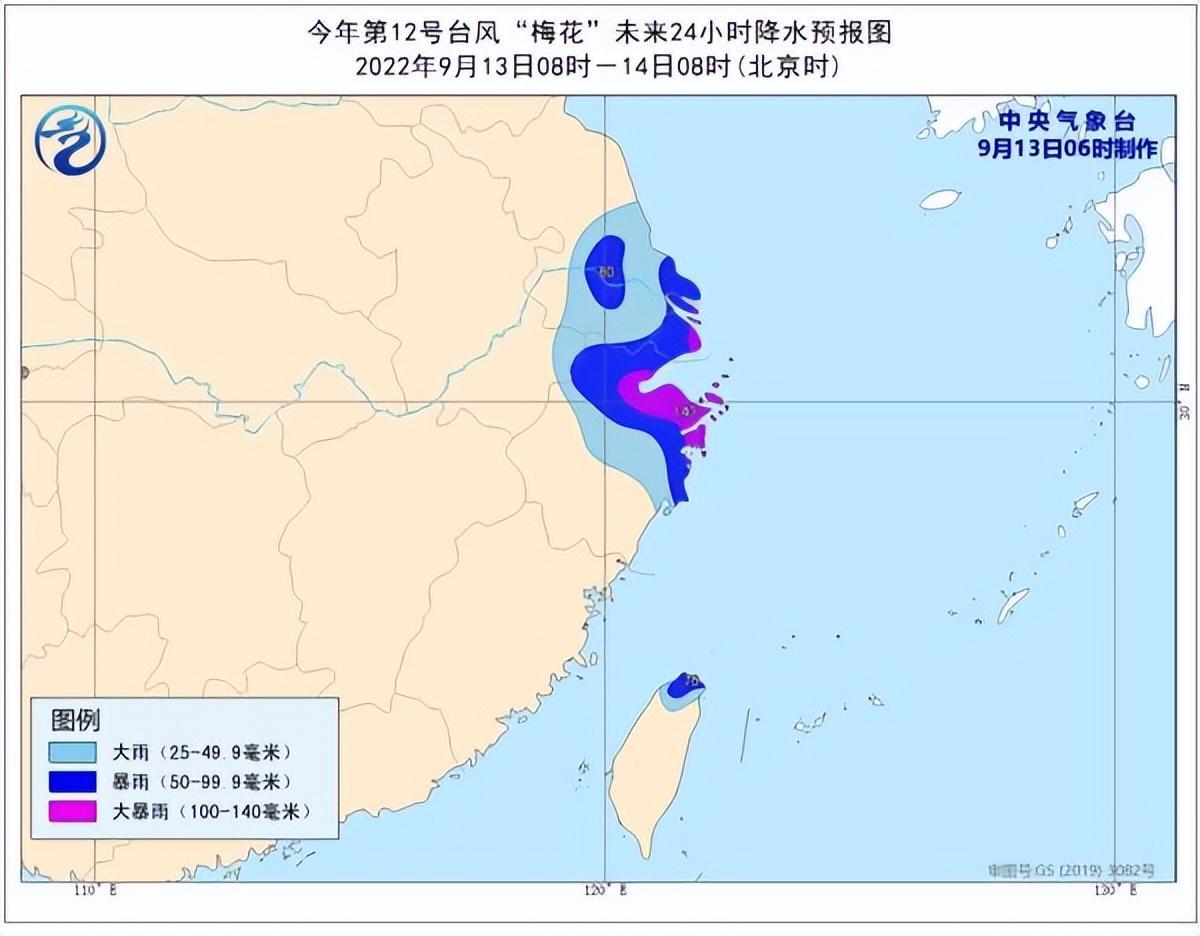
Precipitation forecast:
From 8:00 on September 13th to 8:00 on the 14th, there will be heavy rain in northern Taiwan Island, northern Zhejiang, Shanghai, southeast of Jiangsu, and some areas in northeast Zhejiang and Shanghai. To.
Defense guide:
1. Government and relevant departments do a good job of preventing typhoon rescue emergency in accordance with their duties.
2. Related water operations and past ships should return to the port to avoid wind, strengthen port facilities, and prevent the ship's anchor, stranding and collision.
3. Stop outdoor dangerous operations such as large -scale rally indoor and outdoor and high altitude.
4. Reinforcement or removal of the buildings that are easily blown by the wind. Do not go out freely. You should stay as safe as possible to ensure that the elderly and children stay in the safest place at home, and the dangerous house personnel will be transferred in a timely manner. When the typhoon center passes through the time, the wind will decrease or stand still for a period of time. Remember that the strong wind will suddenly blow. It should continue to stay in a safe place to avoid wind and dangerous houses to transfer in time.
5. Related areas should pay attention to preventing mountain floods and geological disasters caused by precipitation.
- END -
Rice Fragrance Fish Fatty Beautiful

In the golden autumn season, rice is fragrant and beautiful. In the rice+fish bree...
Xi'an Intermediate People's Court launched the "Anti -Organizational Crime Law" preaching activity
The Anti -Organic Crime Law has been reviewed and approved by the Standing Committ...