How strong is the typhoon that may land on the coast of East China this year?Central Meteorological Channel Cover News
Author:Cover news Time:2022.09.13
Cover news reporter Teng Yan
Typhoon No. 12 this year is expected to land in Zhejiang from the afternoon of September 14 to night. On the afternoon of the 13th, at the China Meteorological Administration's media ventilation meeting, Dong Lin, chief forecaster of the Central Meteorological Observatory, said in response to the cover of the cover news that "plum blossoms" may become the first typhoon to land on the coast of East China in recent years. It is not only strong, but also has a serious impact and a large range.
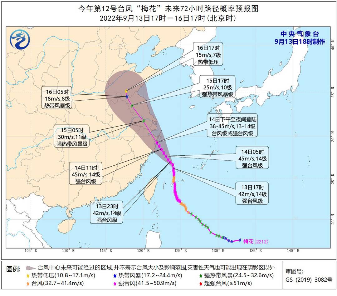
▲ Typhoon "Plum Blossom" this year's 12 -hour path probability forecast chart in the next 72 hours
How big is the wind?
Hangzhou Bay will have 12-14 gusts
The forecast shows that as of 17:00 on the 13th, the "plum blossom" is a strong typhoon level. One hour later, the Central Meteorological Observatory continued to issue a typhoon orange warning. It is expected that "plum blossoms" will move northwest at a speed of 10-15 kilometers per hour. The intensity will be strengthened. Late in the above coastal areas at night (typhoon or strong typhoon). After landing, it will continue to move northwest, and the intensity will gradually weaken.
Affected by it, from 20:00 on the 13th to 20:00, the northern part of the Taiwan Strait, the east of Taiwan, most of the East China Sea, and the waters near the Diaoyu Islands, the waters of the Yellow Sea, the Yangtze River Estuary Area, Hangzhou Bay and the northern part of Taiwan and the eastern coast of Zhejiang, Zhejiang, Zhejiang and Zhejiang The coast, the northern coast of Fujian, the coast of Shanghai, and the eastern coast of Jiangsu will have 6-8 strong winds, and the gusts are 9-11. Among them, there will be 9-11 gale in some seas of the East China Sea, the coast of the central and northern part of Zhejiang, and the Hangzhou Bay. Grade, the nearby sea of the "Plum Blossom" center is 12-14, and the gusts can reach level 15-16.
How strong is the rainfall?
There are heavy rain in parts of the west of Sichuan Basin and other places
From the night of the 13th to the 15th, there will be heavy rainfall in eastern East China, eastern Liaoning. Among them, from 20:00 on the 13th to 20:00 on the 14th, there were heavy rain in parts of the central Zhejiang, Shanghai, Shanghai, Jiangsu, eastern Shandong, and western Sichuan Basin. There are heavy rains in the northeast of Zhejiang, southern Shanghai, and eastern Jiangsu, and there are heavy rainstorms (250-280 mm) in the northeast of Zhejiang. The above-mentioned areas are also accompanied by short-term and heavy precipitation (the maximum hourly rainfall is 30-60 mm, the local area can exceed 70 mm), and there are strong convective weather such as thunderstorms.
Affected by the "cutting line", from the night of the 13th to the 15th, there were middle to heavy rain in Sichuan Basin, western Guizhou, and northern Yunnan.
What is the impact?
"Geological Disaster Meteorological Risk" in Luding Earthquake Disaster Area and other places is high
At 18:00 on the 13th, the Central Meteorological Observatory issued a risk of waterlogging risk meteorological alarm. It is estimated that from 20:00 on the 13th to 20:00 on the 14th, the risk of waterlogging weather in eastern and northern Zhejiang, Shanghai, Shanghai, southern Jiangsu and other places is high. Among them, the risk of waterlogging in some areas in northeastern Zhejiang, high risk of waterlogging and waterlogging in the area, which is very high, and it is easy to form urban waterlogging and farmland stains.
At the same time, the Ministry of Natural Resources and the China Meteorological Administration jointly issued a warning of geological disasters meteorological risk warnings. It is expected that the meteorological risks of geological disasters in the eastern and northern parts of Zhejiang and the northern part of Zhejiang and the central northern part of Zhejiang are more High (yellow warning), high risk (orange warning) in some areas in eastern Zhejiang, and high risk of local local area in northeast Zhejiang (red warning).
How to do a good job?
Need to prevent mountain floods, small and medium rivers floods, etc.
"Zhejiang, Shanghai, Jiangsu, Anhui, Shandong, Liaoning and other places need to do a good job of typhoon defense. Pay attention to the adverse effects of wind and rainy weather on urban operation, transportation, tourism, offshore breeding, and agricultural production. The flood geological disasters and floods of small and medium -sized rivers, ships sailing in the eastern waters of China should avoid typhoon influence areas in time, and maritime operators have been evacuated in time. In addition, rainfall is good for Zhejiang, Jiangsu, Anhui and other places to alleviate weather drought and supplement the river and lake reservoir water storage. Water and agricultural production of water, but need to prevent secondary disasters such as waterlogging and crops. "Dong Lin said.
Experts analyzed that although the "plum blossom" is less than Typhoon Xuanlan Nuo No. 11, because it is closer to the coastal coastal area of Zhejiang, Shanghai, it may be greater than "Xuan Lannuo".
"At present, a case similar to 'plum blossoms' -Typhoon" Kanu "in 2005. At that time, he landed in Taizhou, Zhejiang. When landing, the maximum wind speed of the center was 50m/s. To be strong, the impact on Shanghai is great. "Dong Lin introduced.
Is the typhoon too frequent?
Three "autumn typhoon" appeared in September
In September, the three autumn typhoons of "Xuan Lannuo", "Plum Blossom" and "Miao Bai" were generated one after another. Is it too frequent? Dong Lin said that by September, the number of typhoons has a small number of frequency, the number of login frequency is relatively small, and the autumn is relatively active, which is a normal range, and the overall number of typhoons and the number of login is also in the scope.
Dong Lin emphasized that the sea temperature in autumn is usually high, especially in addition to the high temperature on the land, the temperature at sea is also relatively high, and the maritime accumulation is very strong, so it is prone to a strong typhoon in autumn. In addition, this year's overall typhoon is relatively small, and the small typhoon is very easy to strengthen quickly. "If the" plum blossoms' enter the Chinese waters, the impact of the wind is very strong and need to prevent it. Although the precipitation is relatively lacking, the wind is basically all the wind is basically the wind is basically the wind is basically the wind, but the wind is basically all. Not very good. "
- END -
News!Guigang City's 2022 middle school entrance examination results can be queried

The high school entrance examination in 2022 has endedIs the classmatesIs it anxio...
Zhangdian: "Cross -domain -running Friends Circle" spread to 187 City in 17 provinces

□ Zibo Daily/Zibo Evening News/Expo NewsReporter Chen Daofeng correspondent Chu Y...