Typhoon "Plum Blossom" will be available tomorrow!Central Meteorological Observatory Chief Forecast: The intensity may continue to be strengthened after landing
Author:Red Star News Time:2022.09.13
Typhoon "Plum Blossom" this year was generated on September 8th on the Pacific Ocean northwest. Since then, "Plum Blossoms" moved all the way to the northwest of the north, and gradually approached the coast of Wenling from Zhejiang to Zhoushan.
According to the China Meteorological Administration's report, "Plum Blossom" has been strengthened to a strong typhoon level at 5 am on September 13th. It is highly likely to land on the coast of Wenling from Wenling from Zhejiang to the evening of the night on the 14th. Strong typhoon level.
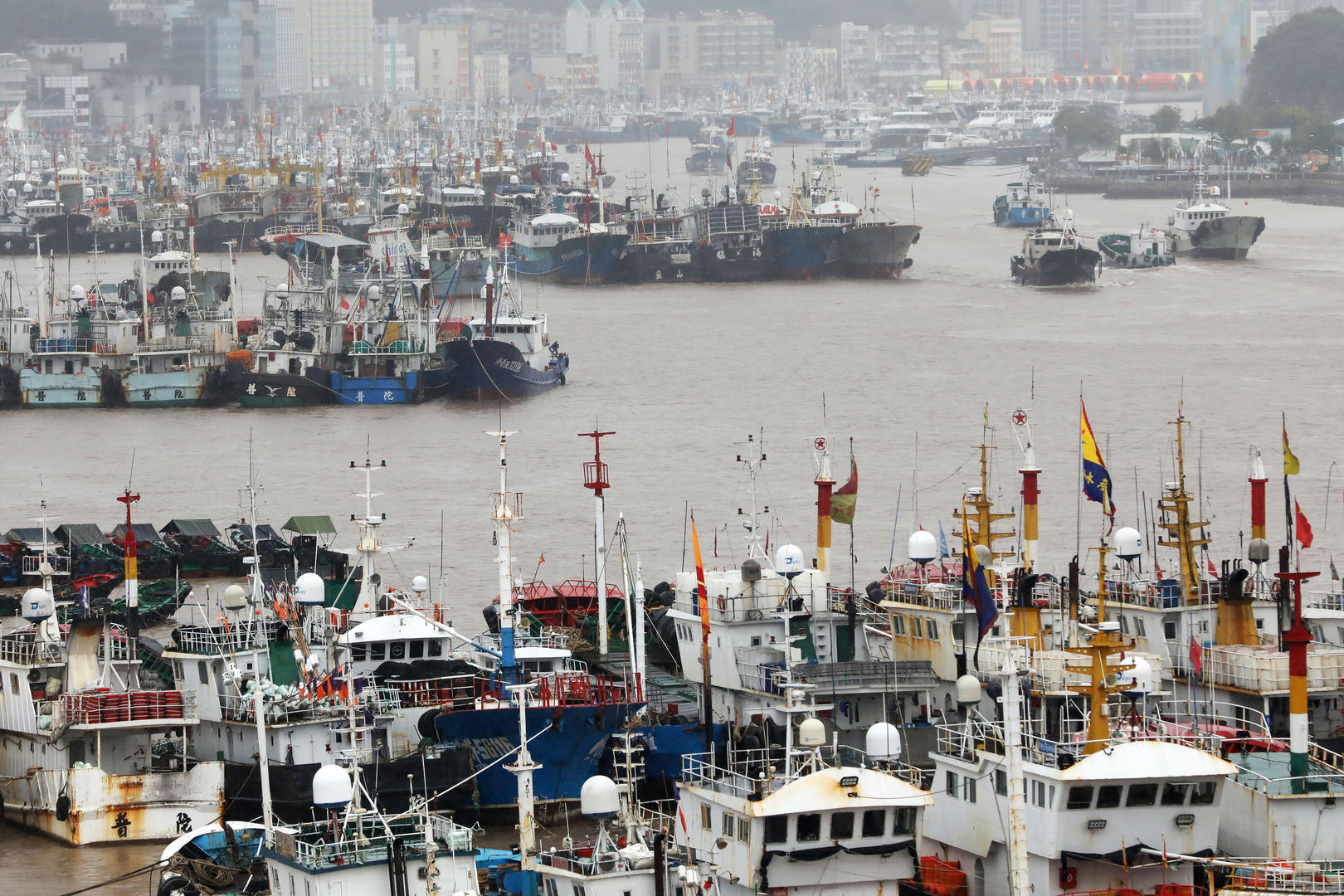
↑ On September 12, in the Shenjiamen Fishing Port, Putuo District, Zhoushan City, Zhejiang Province, fishing boats returned to Hong Kong to avoid risks. According to visual China
As the first strong typhoon to land in East my country in China this year, what kind of impact will "plum blossoms" have on the local area? Is the typhoon speculated by netizens, or the wind is the strongest typhoon in 66 years? Is there an abnormality in this year's autumn platform?
In response to the above issues, Dong Lin, chief forecaster of the Central Meteorological Observatory, responded to the above problems of Red Star journalists at the Typhoon "Meihua" interpretation of the Chinese Meteorological Bureau on the 13th.
Two days and tomorrow
Jiangsu, Zhejiang and Shanghai enter the core period of the strongest typhoon in the wind and rain
Dong Lin, chief forecast at the Central Meteorological Observatory, told Red Star News that the typhoon "Plum Blossom" had been moved into the southern sea of the East China Sea in the early morning of the 13th and strengthened it into a strong typhoon level at 5:00 on the 13th. According to the China Meteorological Observatory, the typhoon "Plum Blossom" will land on the wounds of Wenling from Zhejiang to the wounds of Zhoushan on the afternoon of the 14th. It is expected that the intensity is typhoon or strong typhoon level when landing.
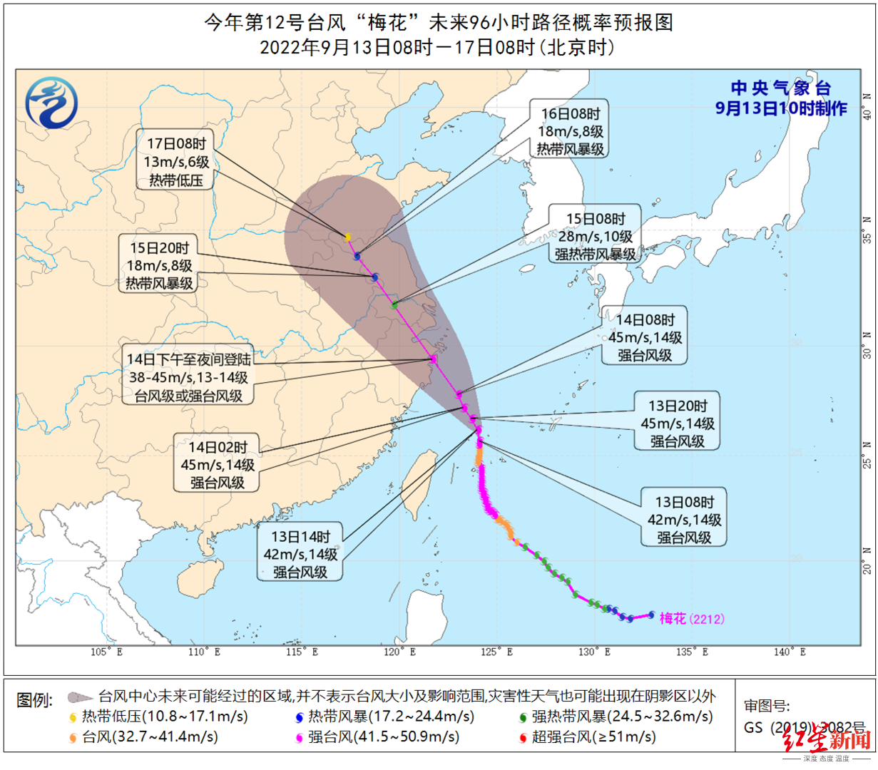
↑ Picture according to the China Meteorological Bureau
Dong Lin introduced that the current center of the typhoon "Plum Blossom" is located on the sea surface of about 435 kilometers east of Xiangshan County, Zhejiang Province, and the maximum wind power near the center is 14 (42 meters/s). The wind ring radius is 220 kilometers to 260 kilometers, the tenth -level wind ring radius is 60 kilometers, and the twelve -level wind ring radius is 30 kilometers.
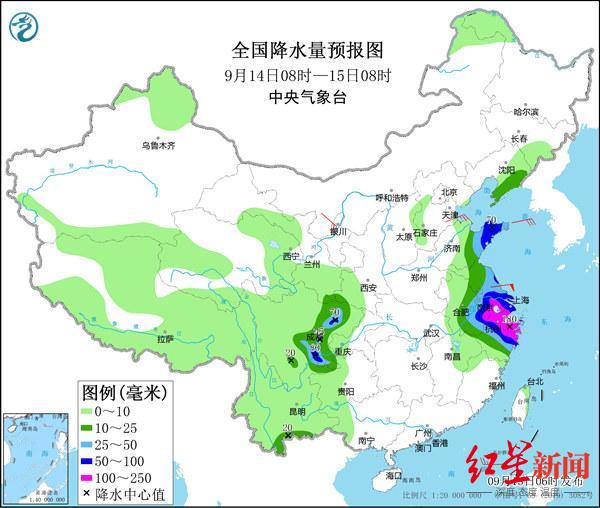
Judging from the current weather, "plum blossoms" have had a storm impact on my country. According to the announcement of the China Meteorological Administration, from September 12th to this morning, due to the combination of typhoons, the inverted grooves and cold air on the north side of the typhoon, significant rainfall in northern Taiwan and Jiangsu, Zhejiang and Shanghai have appeared. There are short -term heavy rainfall.
As the "plum blossoms" go north, the rainfall in northern Taiwan will gradually weaken in the next few days, but the Jiangsu, Zhejiang and Shanghai area will enter the core time of the strongest typhoon in the two days and tomorrow. In other words, tomorrow is the widest scope of heavy rainfall brought by typhoons and the strongest wind.
It is understood that the Central Meteorological Observatory has raised the typhoon warning to an orange warning this morning, and this is also the weather warning level after the highest red warning. At the same time, Dong Lin reminded that with the further turn of the sea temperature and high -rise outflow conditions, the intensity of the typhoon "plum blossom" may be strengthened.
According to the Central Meteorological Observatory, from September 13th to 14th, the bus strait, the northern part of the Taiwan Strait, the southwestern part of the Yellow Sea, the waters of the East China Sea, and the waters of the East China Sea The coast, the coast of Zhejiang, the northern coast of Fujian, the coast of Shanghai, and the southeast coast of Jiangsu will have 6 to 8 high winds, and the gusts are 9 to 11. Among them, some of the East China Sea will have level 9 to 11, and the gusts are 12 to 14.
Among them, heavy rain and heavy rain will be concentrated in southern Jiangsu, southeast Anhui, central Zhejiang, and Shanghai. With heavy rain, the land gusts will reach 8 to 10 in this area, and levels 11 areas in the eastern coast of Zhejiang; stronger winds at sea, and levels of levels from 9 to 11 in the East China Sea. "The wind on the nearby sea of the center is 12 to 14, and the gusts can reach level 15 to 16.
Or affect 12 provinces and cities,
It is helpful to alleviate drought in the middle and lower reaches of the Yangtze River
The current forecast shows that the typhoon "plum blossoms" may stop or rotate near the junction of Su, Henan and Anhui, but the impact of the wind and rain is far more than affecting Jiangsu, Zhejiang and Shanghai.
According to reports, "plum blossoms" will have a great probability that it will penetrate the inland. Affected by the combination of inverted grooves and cold air on the north side of the typhoon, wind and rain will affect Taiwan, Fujian, Jiangxi, Zhejiang, Shanghai, Anhui, Jiangsu, Shandong, Hebei, Henan, Henan, Henan (Eastern bureaus), Liaoning, Jilin, and other 12 provinces and cities, even the possibility of rainfall in northern Jiangsu and Shandong's local area is stronger than the landing point.
↑ Picture according to the China Meteorological Bureau
However, Dong Lin believes that the typhoon "plum blossoms" have affected the storms of my country's coastal areas. Dong Lin introduced that the nearby sea winds passed by the Typhoon "Plum Blossom" center were level 12 to 14, and gusts can reach level 15 to 16. From September 13th to 15th, there were heavy rain in northern Taiwan Island, eastern East China, heavy rain in some areas, and heavy rainstorms in some areas.
Dong Lin said that the impact of typhoon "plum blossoms" should be divided into two. She proposed that on the one hand, relevant departments should pay attention to the adverse effects of the wind caused by typhoons, and especially pay attention to the impact on the coast of East my country and the East China Sea.
In addition, Wang Weiyue, a weather network meteorological analyst in China, also analyzed that due to the east wind of the north side of the typhoon center, the sea water will continue to be rolled into the land.
Wang Weiyue pointed out that at present, the landing location of Typhoon is expected to be along the coast of Wenling from Zhejiang to the area of Zhoushan, and the area of Hangzhou Bay is exactly in the area that is influenced by the east wind. In addition, the terrain of the shape of the speaker mouth makes it easy for the seawater to accumulate in this area and superimposed. The influence of factors such as astronomical tide has caused the water level in this area to rise, and it is not good for urban drainage after the continuous rainfall. It is necessary to prepare for the prevention of urban waterlogging in advance. But on the other hand, Dong Lin believes that, in view of the high temperature impact of the previous period, the drought in the middle and lower reaches of the Yangtze River in my country is more serious. Typhoon precipitation may be more beneficial to alleviate the drought conditions in this area, water storage, and agricultural water.
The strongest typhoon in my country in 66 years?
It is not "the strongest in history", but the impact cannot be underestimated
In order to cope with the typhoon "plum blossom" that will be landed on the 14th, the national defense has improved the emergency response to the flood prevention and typhoon to the third level. At present, the two working groups sent by the National Defense Office are assisted in guiding local flood prevention and typhoons in Zhejiang and Jiangsu provinces. The Zhejiang Provincial Defense Index has launched a second -level emergency response of Typhoon Anti -Typhoon, and Jiangsu, Shanghai, Fujian and other provinces and cities have launched the four -level emergency response of typhoon prevention.
Many netizens speculated about the intensity of typhoon "plum blossoms", which may be the strongest typhoon weather in my country in 66 years. In this regard, Dong Lin gave a negative answer.
For example, Dong Lin said that, in September 2005, the Typhoon No. 0515, which landed in Taizhou, Zhejiang Province in September 2005. At the time of landing, the maximum wind was 50 meters/s, and the intensity was above the typhoon of "Plum Blossom", so although "plum blossoms" The impact of wind and rain has a strong impact, but it cannot be determined that this "plum blossom" has set the biggest typhoon record in 66 years.
Regarding the characteristics of this typhoon "plum blossom", Dong Lin responded to Red Star News that if "plum blossoms" landed in my country on the 14th, then this will become the first typhoon in the East China area of our country this year. "The strongest in history", but the extent and scope of the wind and rain caused by my country cannot be underestimated.
Prior to the formation of the typhoon "Plum Blossom", the previous "Xuan Lannuo", the Typhoon Miao Bai 13, which was on the sea, and the tropical disturbance of the Northwest Pacific. Does Mudu "and so on, indicate that this year's autumn and Taiwan style movement is more abnormal?
In this regard, Dong Lin responded to Hongxing News that typhoons are divided into active and intermittent periods. Generally speaking, the frequency of typhoon generated by typhoons before September is low, and the number of login is relatively small. The number of autumn typhoons and the number of login are still within the small normal range.
In addition, according to the Red Star journalist, in order to cope with the typhoon "plum blossoms", Zhejiang Province has requested that all maritime fishing vessels will return to Hong Kong to avoid the wind before 12 noon on the 13th. All leisure fishing vessels stopped at 18:00 on the 12th, and all maritime breeding staff evacuated ashore. In addition, Ningbo, Zhoushan, Taizhou and other places in Zhejiang stopped classes for one day on the 14th.
At the same time, China Weather Network also reminded the public in Jiangsu, Zhejiang, Shanghai, Shandong and other places to pay attention to early warning and forecast information. It is best not to go out when typhoons come. If outside, do not be in temporary buildings, billboards, iron towers, big trees, big trees, big trees Wait for the wind and rain nearby, and move to the room as soon as possible.
Red Star reporter Yang Yuxi Zhang Yanliang Beijing report
Responsible editor Wei Kongming editor Zhang Li
- END -
"Small and Micro Power" listing the west of the Harbor District of Harbor Village to vigorously improve the level of rural governance

In order to comprehensively promote the implementation of the system of village -l...
Notice!Termination and sampling point adjustment of the nucleic acid detection point of Donggang District!

Pay attention!The sampling point of the nucleic acid detection point of Donggang D...