Nanjing issued a typhoon alert!Rain and rain in the next three days
Author:Nanjing Morning Post Time:2022.09.14
Nanjing Meteorological Observatory today released the typhoon alert and the city's weather forecast today. Today, a typhoon orange warning "plum blossom" has been strengthened that it will have a strong typhoon level. There will be heavy rainstorms. Typhoon No. 12 this year will be moved into the south of the East China Sea in the early morning of today (13th), and it will be strengthened to a strong typhoon level at 5:00. The center is located on the sea surface of about 490 kilometers east of Xiangshan County, Zhejiang Province, is 25.5 degrees north latitude and 124.1 degrees east longitude. The seventh-level wind ring radius is 220-260 kilometers, the tenth-level wind ring radius is 60 kilometers, and the 12-level wind ring radius is 30 kilometers. It is expected that "plum blossoms" will move north to northwest at a speed of 10-15 kilometers per hour, and the intensity will be strengthened. It will gradually approach the coast from Wenling, Zhejiang to Zhoushan. Login along the coastal area (typhoon or strong typhoon level, 38-45 meters/s, level 13-14); after landing, "plum blossoms" will continue to move northwest, and the intensity will gradually weaken. Dafeng forecast: 8:00 on September 13th to 8:00 on the 14th, the bus strait, the northern part of the Taiwan Strait, the southwestern part of the Yellow Sea, the waters of the East China Sea, and the East China Sea, the Yangtze River Estuary Area, Hangzhou Bay, and the northern part of Taiwan Island With the eastern coast, the coast of Zhejiang, the northern coast of Fujian, the coast of Shanghai, and the southeast coast of Jiangsu, there will be 6-8 strong winds, and the gusts will be 9-11. The wind near the sea of "Plum Blossom" is 12-14, and the gusts can reach level 15-16. Precipitation forecast: 8:00 on September 13th to 8:00 on the 14th, there will be heavy rain in northern Taiwan Island, northern Zhejiang, Shanghai, southeast of Jiangsu, and some areas in northeast Zhejiang and Shanghai. -140 mm). Defense Guide: 1. Government and relevant departments do a good job of preventing typhoons in accordance with their responsibilities. 2. Related water operations and past ships should return to the port to avoid wind, strengthen port facilities, and prevent the ship's anchor, stranding and collision. 3. Stop outdoor dangerous operations such as large -scale rally indoor and outdoor and high altitude. 4. Reinforcement or removal of the buildings that are easily blown by the wind. Do not go out freely. You should stay as safe as possible to ensure that the elderly and children stay in the safest place at home, and the dangerous house personnel will be transferred in a timely manner. When the typhoon center passes through the time, the wind will decrease or stand still for a period of time. Remember that the strong wind will suddenly blow. It should continue to stay in a safe place to avoid wind and dangerous houses to transfer in time. 5. Related areas should pay attention to preventing mountain floods and geological disasters caused by precipitation. Typhoon Relief Guide to go out in the next three days of rain and rain. Remember to bring an umbrella source: Nanjing Daily, Nanjing Meteorological, CCTV News Client Editor: Pan Fei
- END -
September 2nd Hebei Province's new coronary virus pneumonia epidemic situation
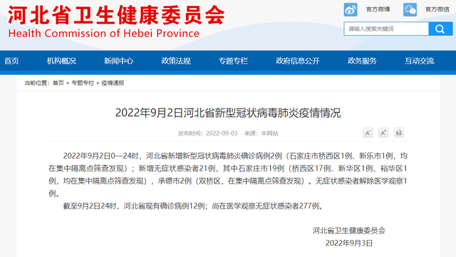
Screenshot of the official website of the Hebei Provincial Health Committee.Great ...
The establishment ceremony of the establishment of the Bo'ai Home Volunteer Service Team of Heachi Street in Hekou Street was held

On the afternoon of June 21, the district Red Cross held a ceremony of establishin...