Central Meteorological Observatory: Typhoon "Plum Blossom" will land on the eastern part of East China in the northern coastal area of Zhejiang will have heavy rainfall
Author:Global Times Time:2022.09.14
1. The weather is active
1. Domestic reality
Typhoon "Plum Blossom" affects East China: yesterday from 08:00 until today at 06, large rainstorms appeared in parts of northern Zhejiang, southeast of Jiangsu, and heavy rain or heavy rain (250-283 mm) in Shaoxing and Ningbo in Zhejiang.
Obvious rainfall occurred in the Sichuan Basin: yesterday at 08 o'clock yesterday until today at 06, heavy rain or heavy rain appeared in the western Sichuan Basin, southern Guizhou, southern Yunnan, and west of Guangxi. The maximum rainfall in the above area is 30 to 70 mm.
2. Foreign actual situation
Southeast Asia and other places in India have strong precipitation: Indian Peninsula, the Central South Peninsula, the Japanese islands, the Great Sunda Islands, the five major lakes in the United States, the Labrado Peninsula, West Africa and other areas are middle to heavy rain, local heavy rain or heavy rain. It is accompanied by strong convection weather such as thunderstorms.
West Asia North Africa and other places are high -temperature: Arabian Peninsula, Iran Plateau, Indian River Plain, Mesopotamia Plain, Algeria, Morocco, Egypt, Sudan, Niger, Libya, Western France, southern United States, western Brazil, Australia, Australia, Australia The maximum temperature in the north and other places exceeds 35 ° C, of which 38-40 ° C in some areas, and the local area exceeds 42 ° C.
2. Key weather forecast
1. Key weather in China
(1) Typhoon "Plum Blossom" will land on the coastal areas northern Zhejiang
Typhoon No. 12 this year's "Plum Blossom" (Strong Typhoon Grade) Center is located on the sea of about 275 kilometers southeast of Xiangshan County, Zhejiang Province on the 14th. Pa, the seven-level wind ring radius is 240-300 kilometers, the tenth-level wind ring radius is 80-100 kilometers, and the 12-level wind ring radius is 50 kilometers. The Central Meteorological Observatory continued to issue a typhoon orange warning at 06:00 on September 14.
It is expected that "plum blossoms" will move northwest at a speed of 20-25 kilometers per hour, and the intensity will be strengthened. It will gradually approach the coast of the northeast of Zhejiang. Login along the coastal area (typhoon or strong typhoon level, 38-45 meters/s, level 13-14); after landing, "plum blossoms" will continue to move northwest, and the intensity will gradually weaken (see Figure 1).
Affected by it, from 08:00 on September 14th to 08:00 on the 15th, most of the waters of the East China Sea and the Yellow Sea, the waters of the Yellow Sea, the Yangtze River Estuary District, Hangzhou Bay and the northern coast of Taiwan, the northern part of Fujian, the southern coast of Shandong, Zhejiang, Zhejiang, Zhejiang There will be 6-8 strong winds and regions in the eastern coast and regions in the eastern part of the eastern part, Shanghai, and regions. Grade 9-11, gust of gusts 12-14, the wind in the nearby sea or area passed by the "Plum Blossom" center is 12-14, and the gust can reach level 15-16.
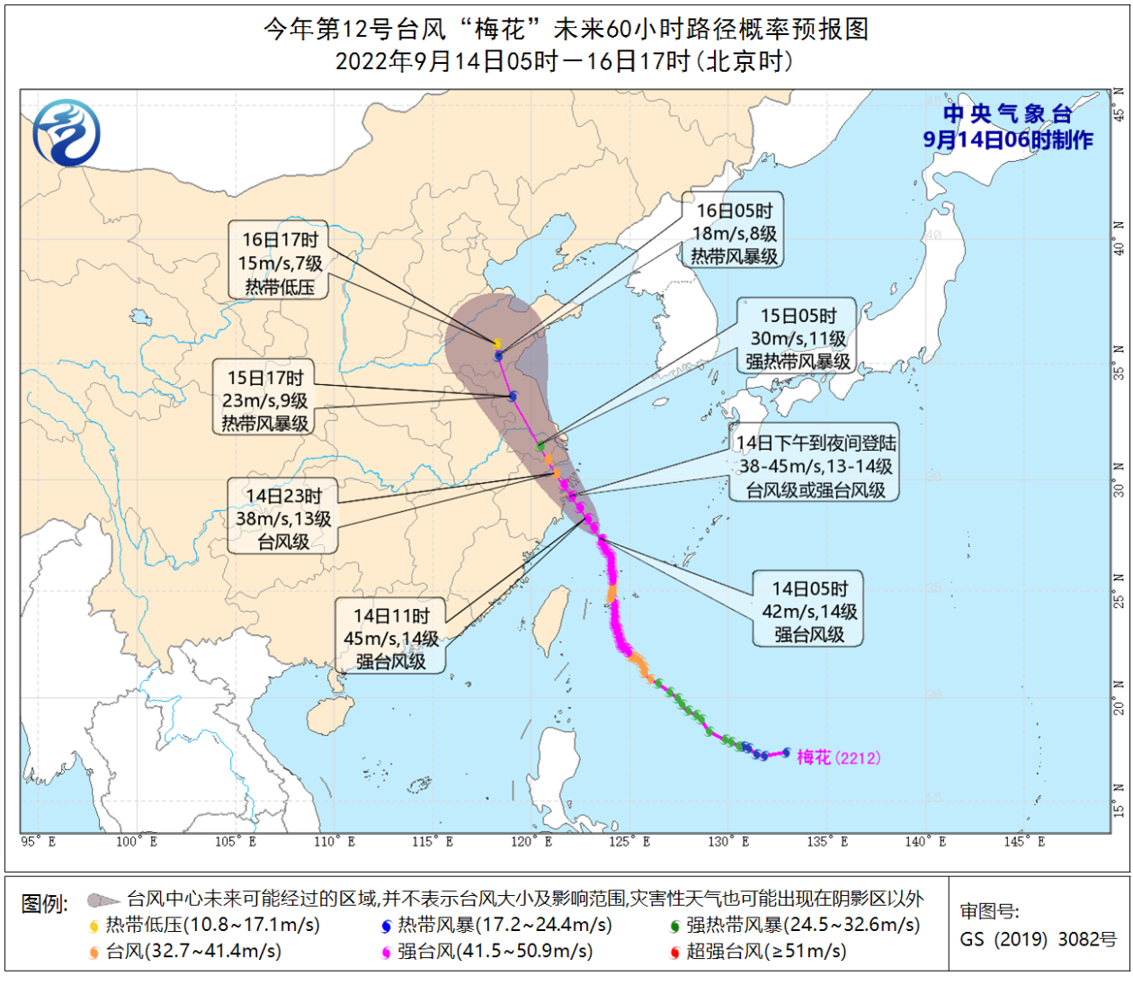
Figure 1 Typhoon "Plum Blossoms" Path Power Probability Forecast Chart in the next 60 hours
In addition, Typhoon Nanda Metropolis (Top Tropical Storm) (English name: Nanmadol; Source: Micronesia; Name: Famous Pohnpei Ruins) is already on the 14th at 02:00 on the 14th. The northwestern Pacific Ocean, which is about 1480 kilometers southeast, is generated by the northwestern Ocean. It is expected to move northwest at a speed of 5-10 kilometers per hour, and the intensity will gradually strengthen. In the next three days, it will have no impact on my country's waters.
(2) There will be heavy rainfall in eastern East China
Affected by the typhoon "plum blossoms" and its reverse slot, from September 14th to 16th, there will be heavy rain in eastern East China, central Liaoning and other places. Among them, northern Zhejiang, Shanghai, eastern Jiangsu, Shandong Peninsula, and central Liaoning and other eastern parts of Liaoning There are heavy rains in some areas of the land. The territorial territories in the northeast of Zhejiang, the cumulative rainfall can reach 50-150 mm, and the local area can reach more than 350 mm.
It is expected that from 08:00 on September 14th to 08:00, Liaodong Peninsula, central and eastern Shandong, Shanghai, Jiangsu, eastern Zhejiang, central Zhejiang, central and western Sichuan Basin and other areas will be as large as heavy rains. There are heavy rains in parts of Shanghai, northeast Zhejiang, etc., and heavy rainstorms in the northeast of Zhejiang (250-280 mm). The above -mentioned areas are accompanied by short -term and heavy precipitation (the maximum hourly rainfall is 30 to 60 mm, and the local area can exceed 70 mm). There are strong convective weather such as thunderstorms and winds. The Central Meteorological Observatory continued to issue heavy rain yellow warning at 06:00 on September 14 (see Figure 2).
In addition, affected by the cutting line, from the 14th to 16th, there were middle to heavy rain in western Sichuan Basin, western Guizhou, and Yunnan.
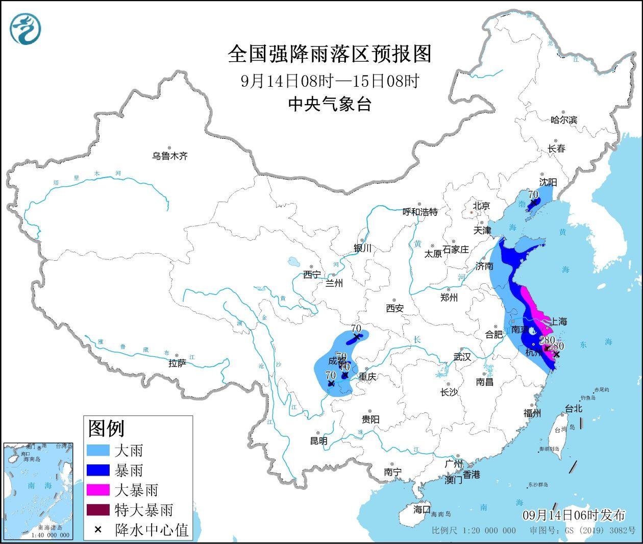
Figure 2 Forecast map of the national heavy rainfall zone (September 14th to 08:00 on September 14th)
2. Key weather abroad
(1) There are strong precipitation in the five largest lakes and Alaska in the Central South Peninsula India and Alaska
In the next three days, the Indian Peninsula, the Central South Peninsula, Indonesia, central Russia and the Far East, southern Nordic, the five major lakes and Alaska, eastern Canada, southern Mexico and other places have middle to heavy rain. Strong wind and other strong convection weather.
(2) West Asia North Africa and other places continue to be high temperature
In the next three days, there are high temperature weather above 35 ° C in the Arabian Peninsula, the Mesoppoca Plain, the Indian River Plain, the North Africa, the United States and the western Mexico, the northern Australia, and the Brazilian plateau. The highest daily temperature of the region exceeds 40 ° C. 3. Specific forecast in the next three days
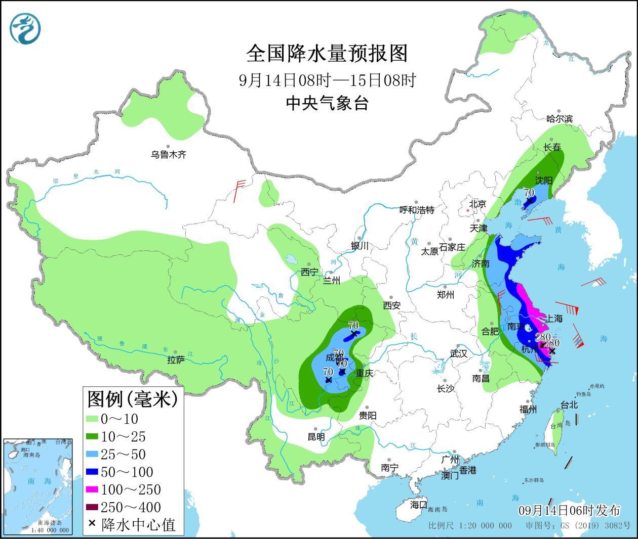
From 08:00 on September 14th to 08:00 on the 15th, there are heavy rains on the Liaodong Peninsula, central and eastern Shandong, Shanghai, Jiangsu, eastern Zhejiang, central Zhejiang, and central and western Sichuan Basin. There are heavy rain in parts of northeast Zhejiang and other areas, and heavy rainstorms in the northeast of Zhejiang (250-280 mm). There are 4 to 6 winds in some areas of Hexi, northern Jiangsu, and central Zhejiang in Gansu. There will be 10-11 levels in the south of the East China Sea, a rotating wind of levels of levels of 10 to 8 to 9, and gusts. There will be a rotating wind of levels 9 to 10 and level 11 (see Figure 3).
Figure 3 National precipitation forecast map (September 14th 08-15 at 08:00)
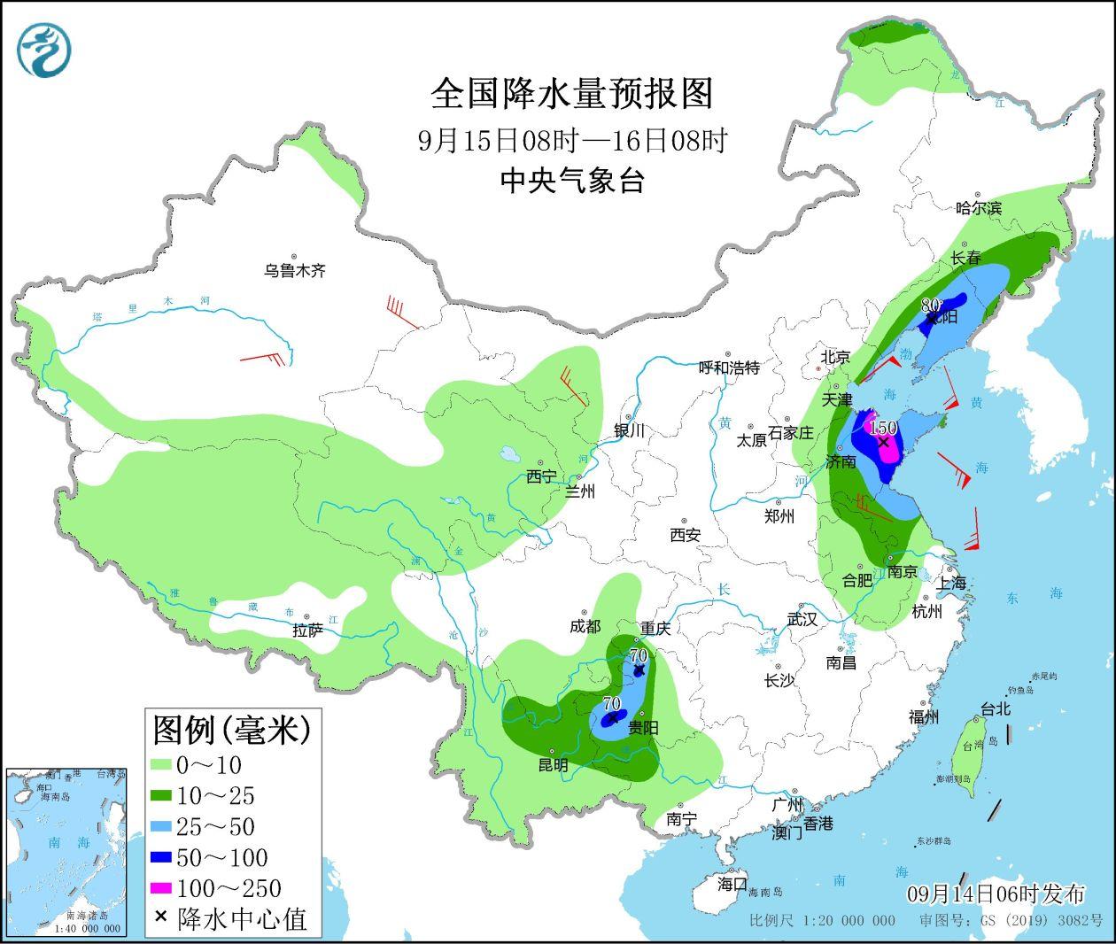
From 08:00 on September 15th to 08:00 on the 16th, there are medium to heavy rain in eastern Jilin, Liaoning, Shandong, central Jiangsu, eastern Anhui, southeast of Sichuan, western Guizhou, northeast of Yunnan, northwestern Guangxi, among them There are heavy rain or heavy rain (100-150 mm) in central Liaoning, central Shandong, and western Guizhou. There are 4-6 or above winds in the northwest of Inner Mongolia, the South Xinjiang Basin, and the northern part of Jiangsu. The southwind, the Bohai Sea will have 5-7 and the northeast wind of level 8 and the 8th gust 8 (see Figure 4).
Figure 4 National precipitation forecast map (September 15th to 08:00 on September 15th)
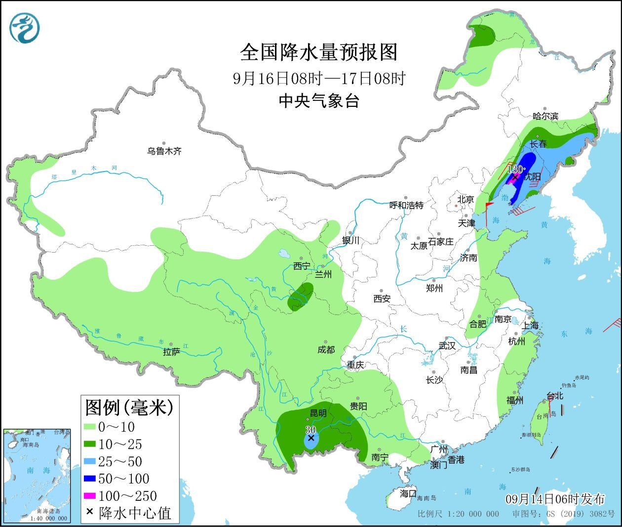
From 08:00 on September 16th to 08:00 on the 17th, there are heavy rain in the northeast of Inner Mongolia, Jilin and eastern Liaoning, eastern Yunnan, southern Guizhou, and west of Guangxi. Among them, there are heavy rain or heavy rain in central Liaoning and other areas. (100 ~ 130 mm). There are level 4 to 6 or above in parts of Liaoning and other places. Bohai will have 7-8 levels, levels 9 levels 9 to 6 to 7, and level 8 of gusts. Southeast wind to the southeast wind of the gust 8th level 8 (see Figure 5).
Figure 5 National precipitation forecast map (September 16th to 08:00 on September 16)
Fourth, influence and attention
1. Zhejiang, Shanghai, Jiangsu, Anhui, Shandong, Liaoning and other places, and the strong wind and rain and adverse effects brought by the typhoon "plum blossoms";
2. There are many rainfall weather in Sichuan, Chongqing, Yunnan, Guizhou and other places.
3. Pay attention to the trend and impact of meteorological drought in the Yangtze River Basin.
Source: Central Meteorological Observatory
- END -
Yinchuan City Xingqing District conducts food safety training in kindergartens in jurisdiction

unOn September 7, the meeting room of the third kindergarten of Xingqing District,...
Daixiang Jingning: Cultural Tourism empowers high -quality development

China Well -off Network Exclusive SpecialtyText | Well -off • China Well -off rep...