Typhoon "Plum Blossom" is here!Stormy is coming!Henan opening the cooling mode
Author:Henan Communist Youth League Time:2022.09.14
Source: Henan Communist Youth League comprehensive from China Weather Network, Henan Meteorological, China News Network, Central Meteorological Observatory, etc.
Typhoon "Plum Blossom" is coming
Central Meteorological Observatory September 14th at 06:00 on September 14th
Continue to issue a typhoon orange warning
It is expected that the typhoon "Plum Blossom" will be available on the afternoon of the 14th to the night
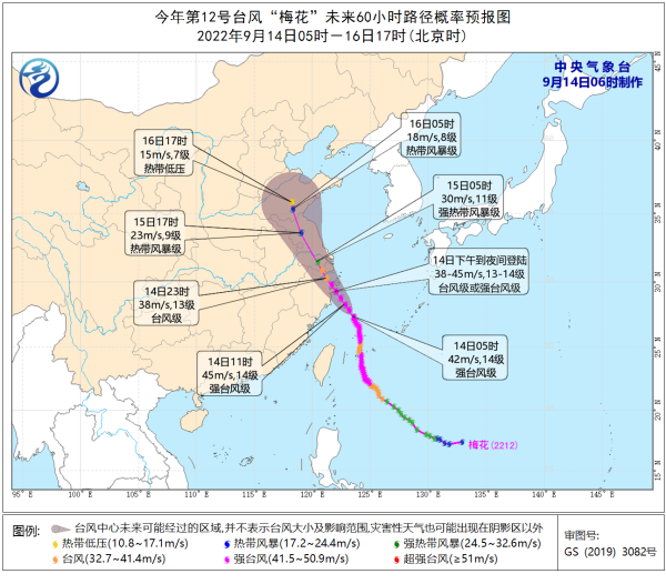
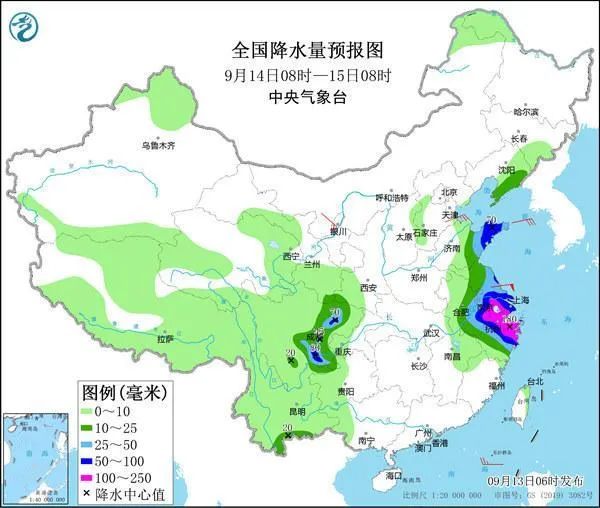
Typhoon No. 12 this year's "Plum Blossom" (strong typhoon level) center today (14th) at 5 o'clock in the morning at the southeast of Xiangshan County, Zhejiang Province, about 275 kilometers in the southeast of Xiangshan County, 27.4 degrees north latitude, 123.5 degrees east longitude, the largest near the center, the largest near the center The wind is 14 (42 meters/s), the lowest air pressure in the center is 955 hundred Pache, the seven-level wind ring radius is 240-300 kilometers, the 10-level wind ring radius is 80-100 kilometers, and the 12-level wind ring radius is 50 kilometers.
It is expected that "plum blossoms" will move northwest at a speed of 20-25 kilometers per hour, and the intensity will be strengthened. It will gradually approach the coast of the northeast of Zhejiang. Login along the coastal area (typhoon or strong typhoon level, 38-45 meters/s, level 13-14); after landing, "plum blossoms" will continue to move northwest, and the intensity will gradually weaken.
Typhoon "Plum Blossom" No. 12 this year
How big is the scope of "plum blossoms"?
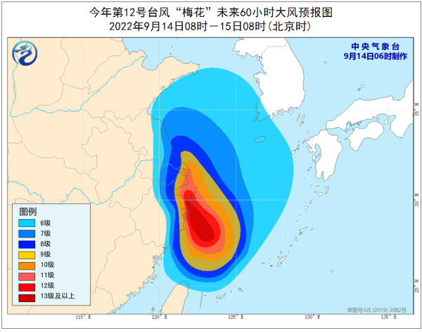
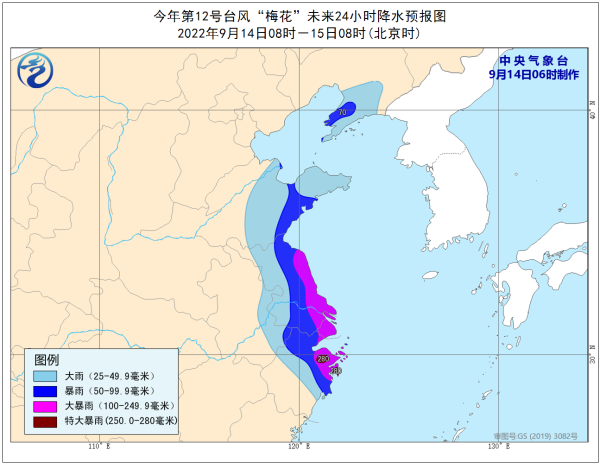
At present, the "plum blossom" is a strong typhoon level. When close to land, the strength will also be strengthened, and it may penetrate in the inland. Affected by the combination of the inverted slot and cold air on the north side of the typhoon, the wind and rain will affect Taiwan, Fujian, Jiangxi, Zhejiang, Shanghai, and Shanghai, and Shanghai. 12 provinces and cities including Anhui, Jiangsu, Shandong, Hebei, Henan (Eastern Bureau), Liaoning, Jilin, and other 12 provinces and cities have not even ruled out that the rainfall in northern Jiangsu and Shandong is more likely to be near the landing point.
At present, Shanghai, Zhejiang, Fujian and other places have released relevant measures to deal with "plum blossoms":
The class stopped on September 14, Jiaxing, Shaoxing and other places in Zhejiang.
On September 14, Shanghai Pudong Airport and Hongqiao Airport have a significant decline in traffic, and more than 50 % of the flights in and out of Hong Kong will be reduced and canceled.
Zhejiang Ningbo Airport canceled all flights on September 14.
From 17:00 on September 13th, the Suzhou Transportation Management Department seized the Taihu Lake, and the passenger ship was suspended at 17:00 on September 13.
The Zhoushan Maritime Bureau has launched an emergency response to the II defense station at 10:30 on September 13. By 12 noon on the 13th, 70 operating water passenger ferry routes operated by Zhoushan were suspended across the line.
According to the news that the Yangtze River Delta Railway was released from the 13th, some passenger trains such as Shanghai -Kunming, Xiao Yan, and Beijing -Shanghai were suspended from the 13th.
As of 11:00 on the 13th, a total of 81 passenger ships were suspended along the coast of Fujian. Ningde, Fuzhou, and Pingtan, which were affected by typhoons, were suspended from 28 water construction projects and 458 people on 30 non -power construction ships were evacuated.

On the 13th, it was affected by the periphery of the typhoon "plum blossom".泱 波 波
Will "plum blossoms" affect Henan?
The answer is yes!

For Henan
Main impact areas: Beijing -Guangzhou Line and East East
Main impact time: 14-16
Xiaoyu is the main, partially to heavy rain
Affected by typhoon "Plum Blossoms" outer cloud system
The rainfall starts from eastern Henan and southeast
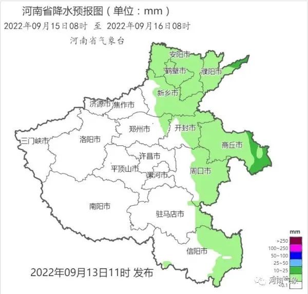
On 15-16, there is a gradual expansion
The overall process of this round is mainly small rain
There are parts to heavy rain in the northern, central and eastern parts, and southeast
Level 4 Gafeng, gust -level level 7
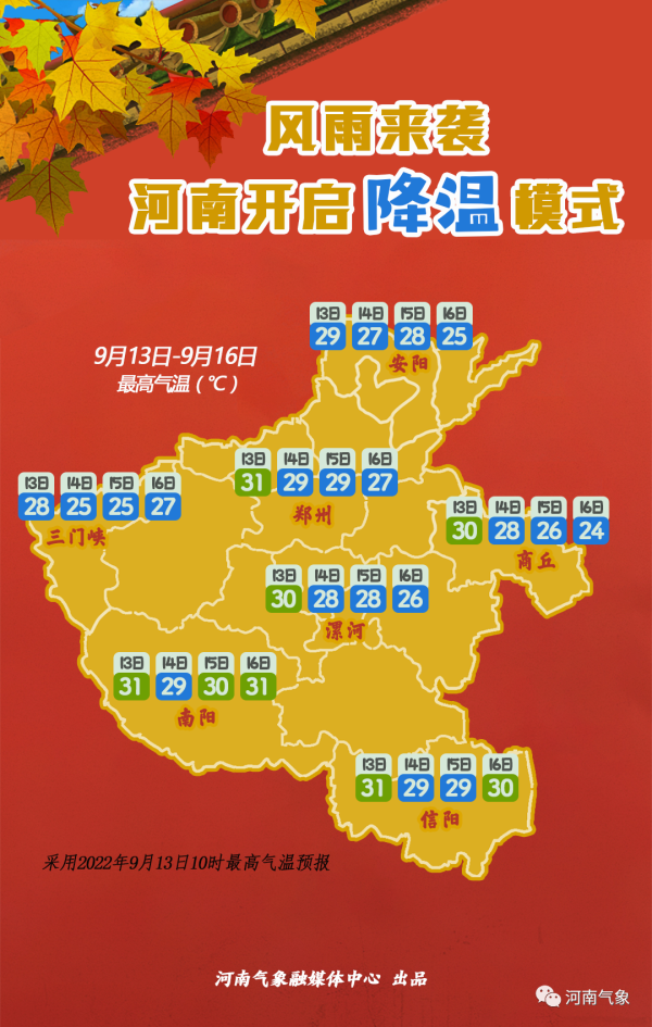
Compared to the "half sunny and half rain" of the sky condition
Great wind and cooling are all province
But the impact is obvious
Still the Beijing -Guangzhou Line and East East
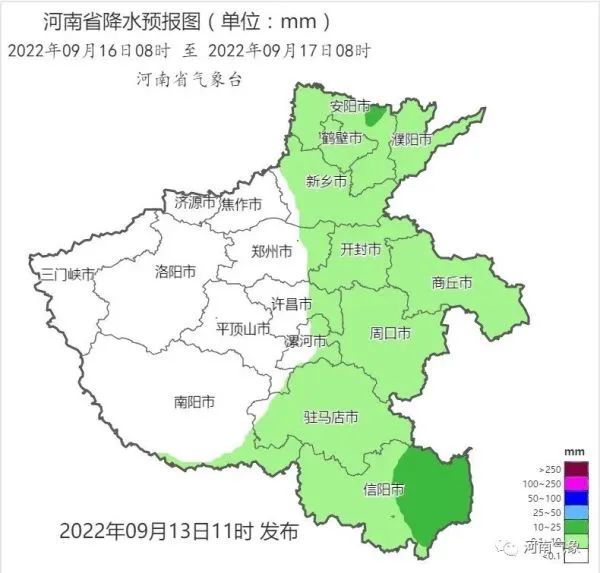
It is expected to be day -to -16 to the 16th
Most northern winds in the province around 4 levels 4
The Beijing -Guangzhou Line and East East Gust of Gust 7

at the same time
The highest temperature also dropped to less than 30 ° C
The wind and rain are cool again!
What can I do to prevent typhoons?
Before the typhoon comes
What preparations do residents need to make?
How to avoid danger when typhoons come?
Poke the picture below to understand


Typhoon strikes everyone to pay attention to the latest early warning forecast information in time
Prepare for defense in advance


, Pay attention to prevention!
- END -
"Civilized Family Deeds Exhibition" Capital Civilized Family: Peng Xingjun Family

Peng Xingjun, Yu Xiuling coupleThirty -one year of marriageThey use ordinary littl...
[Main News] Wu Xianzhe guidance and inspection of Yanlong Road Environmental Sanitation Remediation

On August 24, Wu Xianzhe, deputy secretary of the Yanji Municipal Party Committee ...