Through countless records and analysis of the Qinghai -Tibet Plateau earthquake waves, we found some new phenomena | Bai Ling
Author:Institute of Geological Earth Time:2022.09.15


The pulse of the earth is only given to it.
The Earth Has Music for Those WHO Listen.
Researcher at the Qinghai -Tibet Plateau Institute of Bai Ling · Chinese Academy of Sciences
Gezhi Tao Tao 78 | March 26, 2022 Beijing
Bleak
Hello everyone, I am Bai Ling from the Qinghai -Tibet Plateau Institute of the Chinese Academy of Sciences.
I wonder if you have experienced an earthquake? I was born in Liaoning and had a lot of earthquakes in my childhood memory. For a long time, we all lived in the earthquake. I remember that there were many nights, heavy rain outside, but we could not live in the newly built house, but we could only stay in a humble earthquake.
Perhaps such an experience affects me subtly and let me choose seismics. Over the past 20 years, my colleagues and I have been doing such a thing, that is, studying the earthquake on the Qinghai -Tibet Plateau.
Why is the earthquake on the Qinghai -Tibet Plateau important?
Everyone may be curious, why do we pay attention to the Qinghai -Tibet Plateau? In the impression of many people, the synonym of the Qinghai -Tibet Plateau may be that the local people are rare. Will it have a great impact if the earthquake occurs here? Let's take a look at such a picture first.

The red area in the figure represents the population density. The deeper the color indicates the greater the population density. It can be seen that there are many densely populated areas around the Qinghai -Tibet Plateau, such as Nepal in the southern foot of the Himalayas, the Ganges Plain in northern India, and the Sichuan and Yunnan in my country. In addition, we will also find this phenomenon: near the Qinghai -Tibet Plateau is the main activity area of the plate boundary (the blue curve represents the main activity boundary of the plate structure), and the frequency of the large earthquake occurs is relatively high. In the picture, the circle represents the location of the earthquake. The larger the circle, the higher the level. Therefore, the Qinghai -Tibet Plateau is worthy of attention.
Because of the many important characteristics of the Qinghai -Tibet Plateau, it has a great influence, so 20 years ago, our Qinghai -Tibet Plateau Institute established the mainland collision and plateau Longgang Laboratory to engage in research on this area.
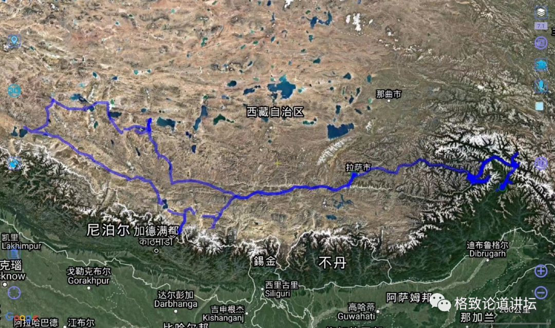
The blue curve in this picture indicates that our main field route basically spans most of the southern parts of the Qinghai -Tibet Plateau. We have to go at least twice a year and run for a month or two to ensure that our instruments can work normally for most of the time.
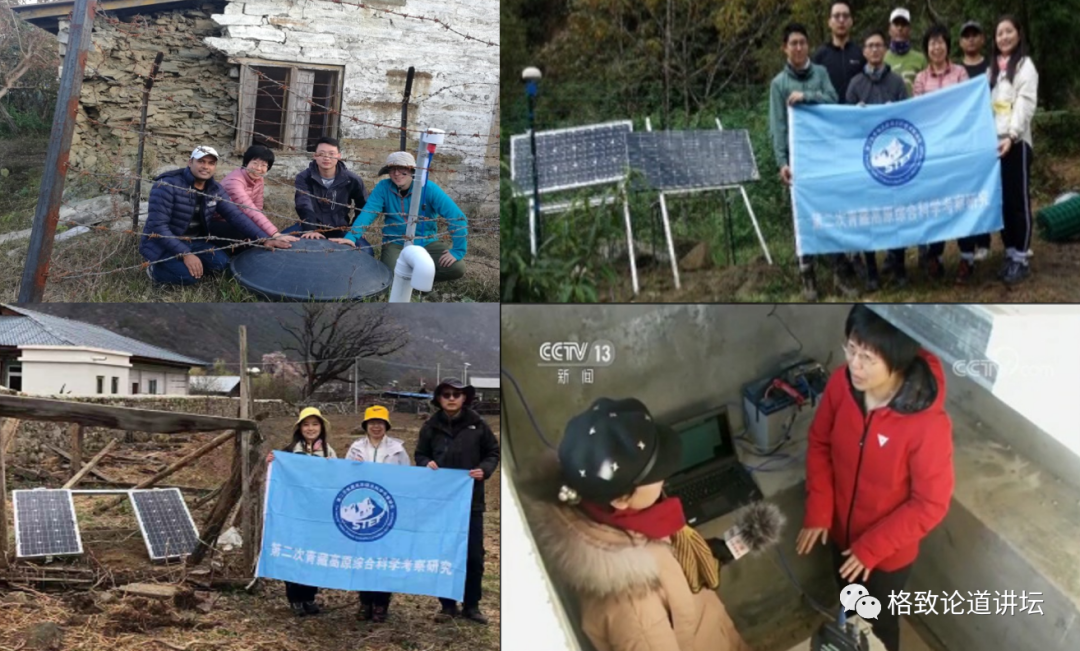
Upper left: Gurkha, Nepal, upper right: Paimo Highway Khan dense
Bottom left: Grand Canyon Gara, lower right: Lulang, Southeast Station of Tibet
These pictures show the situation where we work in the Qinghai -Tibet Plateau.

Left: Earthquakers
Our task is to put the seismic instrument on the left to the Qinghai -Tibet Plateau. The picture on the right shows our normal work: In order to reduce the interference on the surface, we need to carefully choose the location of the seismometer. Usually we dig a pit of one or two meters in the ground to put the instrument on the ground, which can reduce the surface interference and record more useful seismic waves.
Let's take a look at a earthquake wave and listen to its voice.
The sound of earthquake waves (peng et al., 2012)
This is the sound of earthquake waves generated by a magnitude 9.1 earthquake in Japan in 2011. Earthquake waves are mainly transmitted underground, but refraction on the surface will also be spread to the atmosphere. Our ears can hear some signals, but if the frequency is high or low, we can't hear it. Therefore, you need to compress the seismic wave. After the compression treatment of time, you can hear it intuitively.
Everyone may be curious: Why do we want to record earthquake waves and what useful information can they provide to us? In fact, many people compare the earthquake to a beacon that illuminates the ground. By analyzing the earthquake waves, we can understand how the earthquake happened, and we can also know what the earth we can't see.
Different types of earthquake signals

(Van Herwijne and Schweizer, 2011)
Not only that, these instruments are very sensitive to signals. Many weak signals, such as flying aircraft flying in the sky, walking on the ground, these signals will generate seismic waves, and earthquake instruments can be recorded. So how to accurately collect earthquake waves is very important for us.
I am very lucky as an earthquake scholar. These instruments we set up on the Qinghai -Tibet Plateau have recorded countless and small earthquakes. Some earthquakes occur on the Qinghai -Tibet Plateau, and some even occur on the other side of the earth. It can be seen that these earthquake waves can penetrate the entire earth.
In my memory, three incidents impressed me very deeply. Below I will share with you the three earthquake -related stories.
Three stories about seismic waves
Completed: 50%///////////
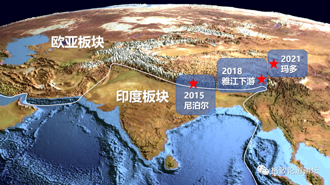
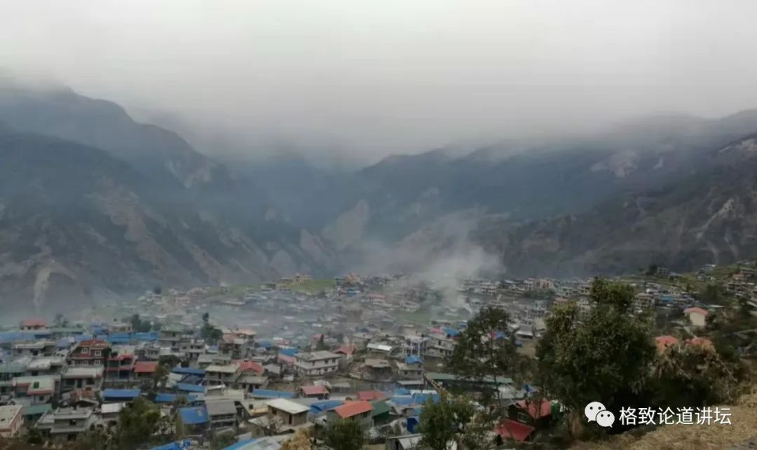
In 2015, a magnitude 7.8 earthquake occurred in Nepal, of which Barpak was one of the most affected areas.
The Town of Barak, Nepal at the earthquake site
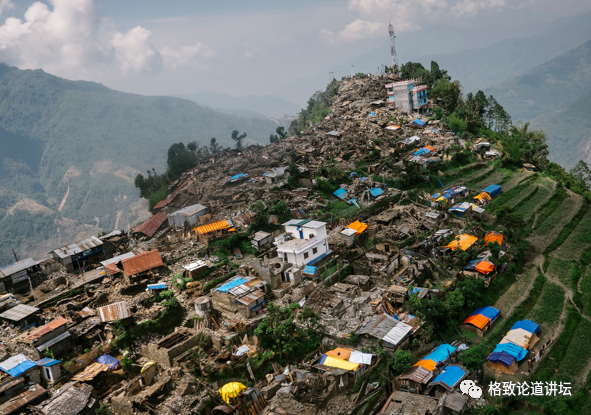
This picture is the town of Bapak after the earthquake. It can be seen that many houses collapsed and were razed to the ground. This is also the hometown of our research group international student Sanjev. At that time, I met Shang Tao for the first time at the University of Tribwin. He told me that he wanted to give up physics, study graduate students of the earth, and specialize in the earthquake.
Barpak town that resume rebuilding
Five years later, we went to the scene again and took the look of the reconstruction of the town of Bapak. It can be seen that there has been slowly recovering the calmness of the past. But what are the reasons for this earthquake? Is there no signal such a large earthquake? Is there no precursor information? These issues have always troubled our seismic workers.
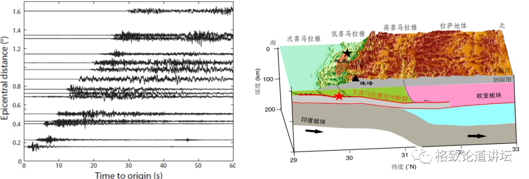
To solve these problems, we need to observe the earthquake. Fortunately, before the earthquake occurred, we set up many earthquake stations on the border between China and Nepal. For five years, these stations have recorded more than 1,000 earthquakes above 3.5 times. It is precisely because of this observation that there is data from nearby stations that the truth is getting closer and closer to us.
Through these earthquake waves, we re -determined the position of the earthquake, greatly improved the accuracy of the earthquake positioning, and narrowed the error of a magnitude. We further discovered that the location of these earthquakes may have a lot to do with the perspective of the Indian sector's dive from the bottom of the Eurasian plate, and the changes in these dive angles may affect the rise of the Qinghai -Tibet Plateau. Therefore, we have some new understanding of these issues.
But we still have many problems that have not been solved for the occurrence of earthquakes. Our international student Shang Tao has now changed from a master's degree to a PhD, and continues to carry out this work.
The Nepalese earthquake is large, but it is unexpected that its surface activity is not very obvious. When we went to the town of Bapak, we did not find significant signs of surface activities. In fact, the magnitude of many earthquakes is not large, but there are many obvious activities on the surface, such as the Mado earthquake that occurred in 2021 and the gate source earthquake that occurred in 2022. In 2021
2022 Gate Source 6.9 Earthquake Lan New High Speed Railway
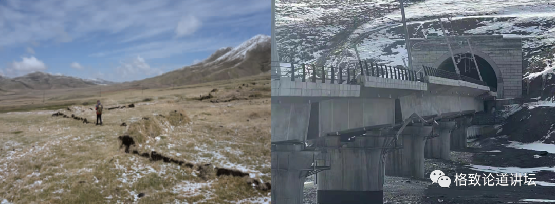
On the left is a picture of the Mardo earthquake. You can see a long surface break zone with a length of 160 kilometers, which is equivalent to the distance from Beijing to Tianjin. The picture on the right is a door -source earthquake. The broken belt just passed through the Lanxin high -speed rail, so some sections were severely damaged.
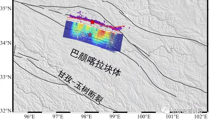
Why are these seismic faults so big? What does its underground structure look like? These issues have aroused our great interest. Through earthquake waves, we further analyzed the structure of the Mago earthquake.
The red represents the distance of sliding at the broken level. The darker its color, the greater the distance between the sliding. For example, if we put the two wooden blocks together, and the surface of the wooden block is rough. In this case, we need to use a lot of power to staggering them. Once staggered, the distance between sliding will be greater, which is the position represented by the red color in the picture.
For a known fault, if the roughness of which regions can be found is relatively large, we can roughly estimate that the most likely to slide there in the future. In order to carry out long -term observations, we set up an earthquake station, hoping to test these conclusions one day.
In addition to the conventional earthquake waves, our instruments can also record many different signals, such as ice lamblite blocked rivers and mudslides.
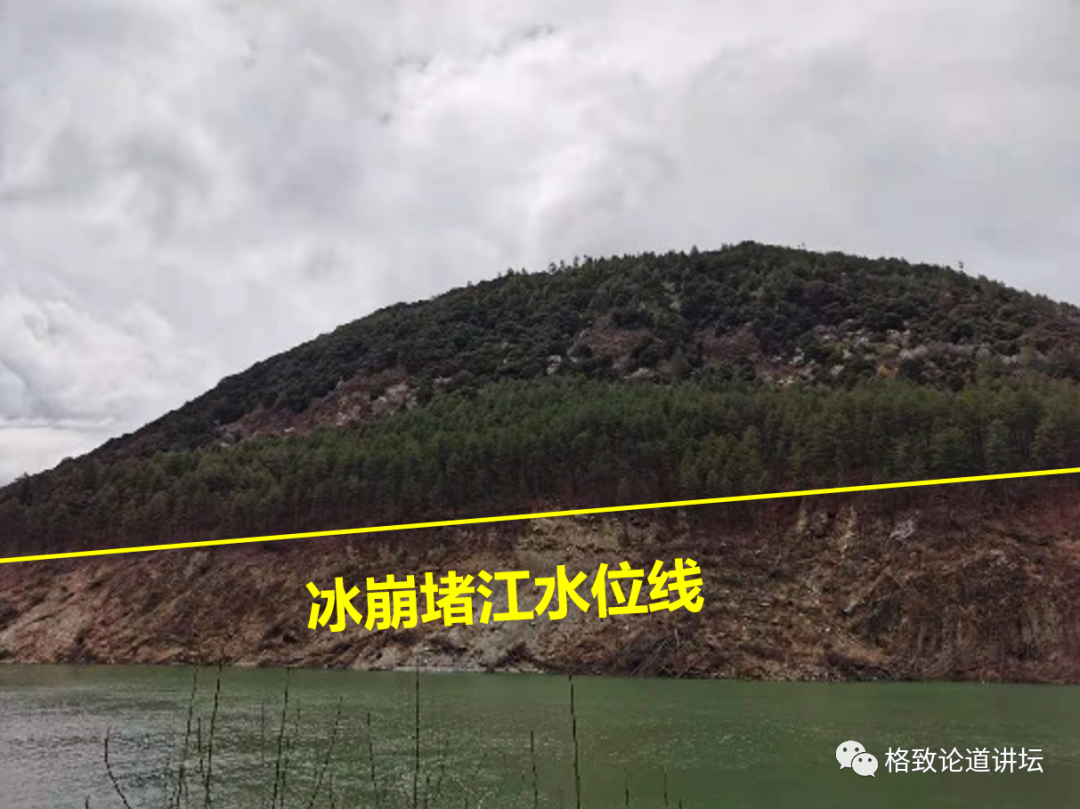
In fact, there are many places in the Qinghai -Tibet Plateau area covered with ice and snow all year round. If ice collapses in these places, a series of problems will cause a series of problems. Especially in the lower reaches of the Yarlung Tibetan River, once the river is blocked, the water level of the Yarlung Tibetan River will rise rapidly.
The picture above is what we have taken at the scene. In 2018, many incidents occurred, so you can see a clear water level line.
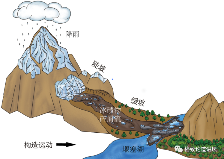
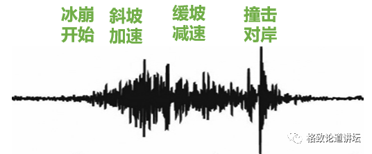
So we further analyzed the waveforms of the Bingnu Earthquake waves. From the perspective of the amplitude, the entire waveform is divided into several different stages, which correspond to the continuous processes such as when these events occur and how to occur. So these signals are very important, and the information it records cannot be observed by other instruments.
Listen, the sound of earthquake waves
Completed: 90%///////////
Through the above three examples, we can know that we can find some new phenomena on the analysis of the seismic waves. But it is undeniable that we feel that some results are still too late. In our work, how to apply these scientific discoveries to the fields of earthquake prevention and disaster reduction in time, this will be a subject we have always faced in the future.
Through the analysis of earthquake waves, you can locate the earthquake and understand the structure inside the earth. So for those who study the earthquake, the earthquake wave is the pulse of the earth. I believe that these pulse can tell us the cause of the earthquake and help us find a way to prevent earthquake prevention and disaster reduction. Finally, let's listen to these earthquake waves.
This is the 2015 Nepal earthquake.
This is the Mado earthquake in 2021.
Finally, the ice collapse in 2018.
This is my sharing. thank you all!
- END -
New Beibei King!The new generation of Honda CIVIC TYPE R will be introduced to China | Cover every day, see the fire wheel

On July 21, the new generation of CIVIC Type R, which has attracted much attention...
High -speed does not free 2022 Mid -Autumn Festival Holiday Tai'an high -speed travel guide

The Mid -Autumn Festival holiday was 3 days (September 10th to 12th) in the Mid -A...