Typhoon "Plum Blossom" will be moved into Jiangsu tonight to go to the coast of Shandong
Author:Sichuan Observation Time:2022.09.15
The Central Meteorological Observatory issued a typhoon yellow warning at 06:00 on September 15:
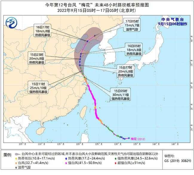
The center of Typhoon "Plum Blossom" No. 12 this year has logged in again on the coast of Fengxian in Shanghai around 0:30 am today (15th). The maximum wind near the center was 12 (35 meters/s), and the lowest air pressure in the center was. 975 Papa. Before 5 o'clock this morning, "Plum Blossom" moved into Jiangsu Province and weakened to a strong tropical storm. At 5 o'clock, it was located in Haimen, Jiangsu Province. It was 31.9 degrees north latitude and 121.2 degrees east longitude. ), The lowest air pressure in the center is 980 Baipa.
It is expected that "Plum Blossom" will move north to west at a speed of 25-30 kilometers per hour. Today, it will pass through the coast of Jiangsu from south to north today. Log in to the southern coast of the Shandong Peninsula today (tropical storm level, 20-23 meters/s, level 8-9), and then gradually shifted to the east of the north. After passing through the Shandong Peninsula, it will move into the Bohai Strait during the day on the 16th. And gradually transgender into temperate cyclones.
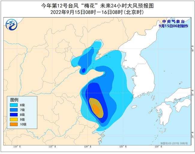
Dafeng forecast: September 15th to 08:00 on the 16th, north of the northern part of the East China Sea, most of the Yellow Sea, Bohai, Bohai Strait, Yangtze River Estuary District, Hangzhou Bay, Shanghai Coast, East Jiangsu Coast, Shandong Coast, Liaodong Peninsula coastal coastal coastal coastal coastal There will be 6-8 high winds and gusts 9-10. Among them, the west of the southern part of the Yellow Sea and parts of the parts of the eastern coast of Jiangsu will have a level 9-10, and the gusts are 11-12.
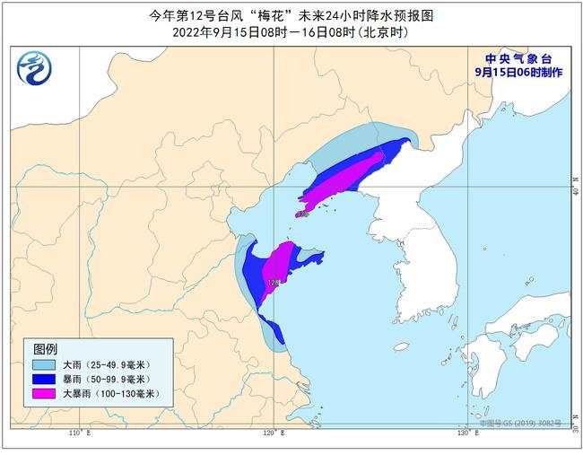
Precipitation forecast: September 15th to 08:00 on the 16th, northeastern Jiangsu, central Shandong, central Liaoning, southeast of Jilin, and other places have heavy rains. Among them, the western Shandong Peninsula, Liaodong Peninsula, and eastern Liaoning areas There are heavy rains (100-130 mm) in some areas. The above -mentioned areas are accompanied by short -term and heavy precipitation (the maximum hourly rainfall is 30 to 60 mm, and the local area can exceed 70 mm). There are strong convective weather such as thunderstorms and winds.
Defense guide:
1. Government and relevant departments do a good job of preventing typhoon rescue emergency in accordance with their duties.
2. Related water operations and past ships should return to the port to avoid wind, strengthen port facilities, and prevent the ship's anchor, stranding and collision.
3. Stop outdoor dangerous operations such as large -scale rally indoor and outdoor and high altitude.
4. Reinforcement or removal of the buildings that are easily blown by the wind. Do not go out at will. You should stay as safe as possible to ensure that the elderly and children stay at home the safest place, and dangerous house personnel transfer it in a timely manner. When the typhoon center passes through the time, the wind will decrease or stand still for a period of time. Remember that the strong wind will suddenly blow. It should continue to stay in a safe place to avoid wind and dangerous houses to transfer in time.
5. Related areas should pay attention to preventing mountain floods and geological disasters caused by precipitation.
Sichuan Observation (Source: China Weather Network)
- END -
Notice!From 17:00 on July 10th to 18:00 on 8:30, Hebei Settlement Settlement to handle some employment business
On July 7, the Human Resources and Social Affairs Department of Hebei Province issued an announcement that according to the construction of the Hebei Provincial Human Resources and Social Affairs Inte
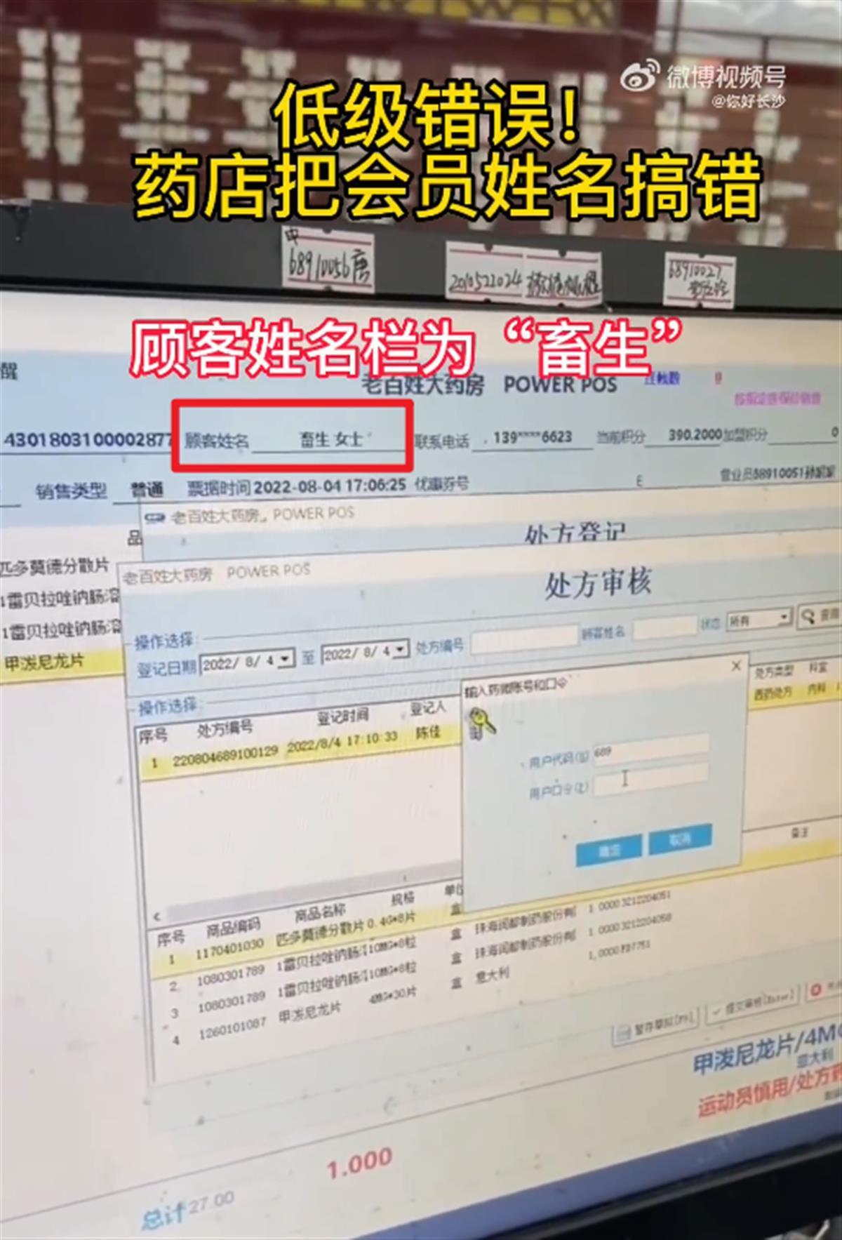
The company's response to the member's name was written as "beast": the pharmacy system was wrong, apologized and strengthened management
Jimu Journalist Ding WeiVideo editing Ding Wei