Typhoon "Plum Blossom" will still have heavy rain and wind around the eastern part of Shandong from the coast of Qingdao around the coast of Qingdao on the 16th.
Author:Qilu.com Time:2022.09.15
Qilu.com · Lightning News, September 15th. The Meteorological Observatory of Shandong Province released the Meteorological Service Express today at 16:50. Typhoon No. 12 this year, "Plum Blossom" (tropical storm level) at 16:00 on the 15th, is located in the center of the east of Lianyungang City, Jiangsu Province About 120 kilometers of Yellow Sea on the south of the Yellow Sea. It is expected that "plum blossoms" will move north at a speed of 15 to 20 kilometers per hour. The center will enter Shandong from the coast of Qingdao around the early morning of the 16th. After passing through the Shandong Peninsula, it will move into the Bohai Strait from near Penglai on the morning of the 16th, and on the morning of the 16th, and Gradually transgender is temperate cyclone.
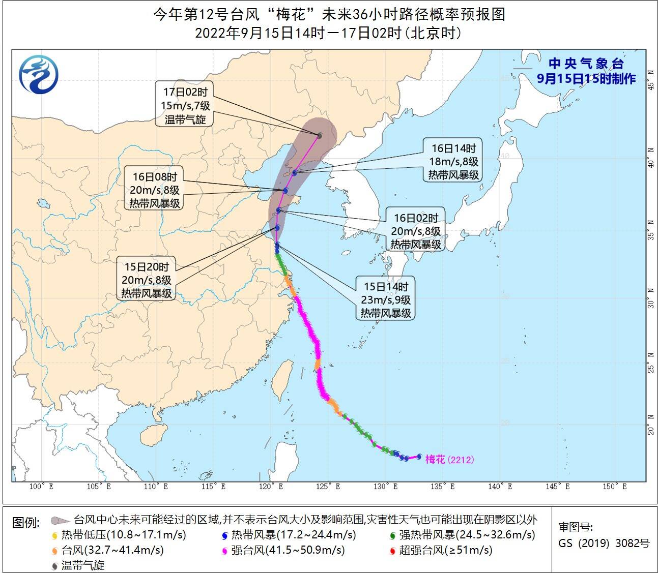
Typhoon No. 12 "Plum Blossom" mobile path forecast chart
Stormy
Affected by "plum blossoms", from 06:00 to 16:00 on the 14th, there were 97 counties (districts and cities) and 1300 towns in the province. The average precipitation was 24.4 (mm, the same below), and the amount of water was about 3.83 billion cubic meters.
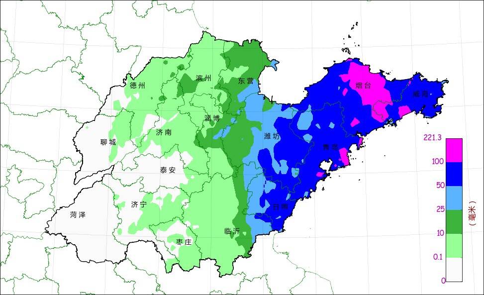
September 14th to 16:00 on the 15th of Shandong Province (millimeter)
The average cities: Yantai 92.4, Weihai 78.8, Qingdao 78.0, Rizhao 53.8, Weifang 38.4, Dongying 16.7, Zibo 9.8, Linyi 6.9, Binzhou 6.0, Texas 1.9, Jinan 1.7, less than 1 or precipitation without precipitation. There are 1 stations exceeding 200.0, 11 of 150.0 ~ 200.0, 60 from 100.0 ~ 150.0, and 370 of 50.0 to 100.0. Qingdao Bihai Lantian 182.1. The current radar precipitation echo is mainly located in Weifang, Linyi, Rizhao, Peninsula, and the middle of the Yellow Sea, and the Bohai Strait.
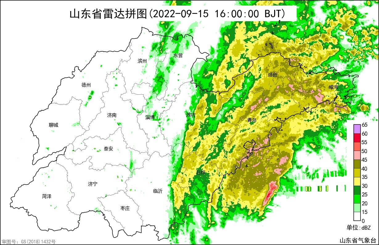
September 15th at 16:00 in Shandong Province radar puzzle
From 14-15, level 7 to 8 gusts appeared in the middle of the Yellow Sea 9 to 10 Northeast winds, and the largest level 10 (27.3 meters/s) in Nanda Island in Qingdao; 6-7 gusts 8 gusts of Grade 6 to 7 in the north of the Bohai Sea, Bohai Strait and the north of the Yellow Sea. Grade Northeast Wind.
Prediction
It is expected that on the night of the 15th, Qingdao, Yantai and East Weifang will have a heavy rainstorm (40-80 mm local 100 to 150 mm locally), Weihai, Dongying, Zibo, Weifang west, and Rizhao local heavy rain or heavy rain (10 ~ 20 20-20 There are small rain in Binzhou, eastern Jinan, eastern Jinan, and Linyi in east of Jinan; during the day of the day, the weather in Dongying, Weifang, and Peninsula are cloudy, and the weather in other areas turns cloudy.

September 15th to 20:00 on the 16th of the precipitation forecast diagram (millimeter)
On the night of the 15th, the southeast wind in the middle of the Yellow Sea turned southwest wind 8-9 gusts 11-12, and the Bohai and Bohai Straits northeast winds of 7-8 gusts from levels of 7 to 10 gusts to level 8-9 gusts 11-12, north of the Yellow Sea, northern Yellow Sea Southeast wind level 8 gusts 9-10; during the day of the 16th, the northeast wind of the Bohai Strait is weakened from level 11-12 gusts to level 7 gusts 8-9, and the northeast wind of the Bohai Sea is weakened at levels 8-9 gusts. By level 5-6, the northern part of the Yellow Sea weakens at level 8 to 10 gusts at level 8 to 10 gusts, and the middle of the South Wind 8th Gust of the middle of the Yellow Sea is 9-10 to the north wind 5-6. From the night of the 15th to the day of the day, the 5-6 gusts of the northeast wind of Rizhao and the northeast wind of the Peninsula region will turn to level 7 to 10 gusts at level 7 to 4 to 4 to 4. Grade enhancement to level 6 to 7 gusts 8-9 to Nanfeng 3, and the level 4 to 5 gusts of north winds in other areas weaken to level 3.
Typhoon No. 13 "Miao Bai" and Typhoon No. 14 "Nanma Du" trend analysis
Typhoon Miao Bai, No. 13 this year, was transformed into temperate cyclones in the Northwest Pacific Ocean surface on the afternoon of the 15th.

Typhoon "Plum Blossom", "Miao Bai", "South Macu" mobile path forecast map
Typhoon No. 14 this year, "Nanda Metropolis" (Typhoon Level) at 14:00 on the 15th, is located on the Pacific Ocean, about 1320 kilometers northwest of Guam in the United States, and has the largest 12 levels near the center. It is expected that "Nanma Du" will move north to north at a rate of 15 to 20 kilometers per hour, and the intensity will gradually increase. The maximum is likely to move from the southern part of the Korean Peninsula to the northeast on the 19th. Affected by the "Nanma Metropolis" and cold air, there will be obvious windy weather in the sea areas of our province on 18-19.
"Nanma Metropolis" is far from Shandong, and its later paths and impact on Shandong are still uncertain. The meteorological department will closely monitor the changes in weather, strengthen tracking and judgment, and scroll time to issue forecast early warning information.
Lightning News reporter He Zewei reports
- END -
Shanwan Morning News 丨 Taiyuan Xiaodian District adjusts the sampling point of the nucleic acid sampling point; many people return to Beijing on the way back to Beijing; on August 31, Taixin Avenue (Taiyuan section) opened

Good morning Success has never come overnight, but accumulated from the moment of...
Social security has been paid for 15 years, can you pay for it?Look at the authoritative answer →

Social security has been paid for 15 years, can you pay for it? The Municipal Huma...