High score special -Aerospace Technology's "100 million points" application in the field of people's livelihood
Author:Chinese aerospace Time:2022.09.15
Recently, CCTV's "Open Lecture" program invited Liao Chujiang, a researcher at the National Space Administration on the ground observation and data center, shared the inheritance of the "two bombs and one star spirit" in the high score.
In the show, Liao Chujiang shared such a picture to us. Do you know what this picture is?
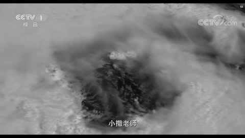
In fact, this picture is the monitoring result of Typhoon Ni Typhoon, which was taken with a fifty -meter resolution camera on the 36,000 -kilometer orbit of the Earth in 2016.
The image was praised by the meteorological expert at a international weather conference. Because they have never seen the structure of the typhoon eyes shot with high -resolution satellites.
Soon after the use of the high score 4th satellite was put into use, the typhoon was captured, which increased the accuracy of the typhoon path forecast by ten kilometers. According to the international traffic algorithm, every one kilometer increased by the accuracy of the typhoon path, the loss decreases by 100 million yuan, which means that the typhoon path forecast to the medium -to -high score 4 satellite will reduce the loss of one billion yuan.
Liao Chujiang said: "We also gained a sense of honor and accomplishment in this process. This is the biggest enjoyment of my life."
The characteristics of high -scoring satellites are insight into the world, which will be widely refined. This feature represents a pragmatic spirit. It can also notice the subtleties while observing the vast and vast earth, and it can solve the problem of the people's anxiety.
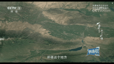
Xinjiang's grassland area is widely distributed, reaching 500,000 square kilometers. To fully understand the status of these grasslands, you must survey on the spot, but some unmanned areas can only ride horses. Each survey takes more than ten days, which consumes labor and material resources.
The local person in charge had thought of using remote sensing data to solve the problem, but the development of my country's remote sensing satellite more than ten years ago was not good. Foreign satellite data were expensive. The price of a hundred square kilometers of grassland was close to 50,000 yuan. This cost could not be afforded.
After the high -scoring satellites were launched in 2013, the data obtained were distributed to each unit for free. The headmaster of the Xitianshan Prairie Station in Xinjiang no longer had to spend more than ten days to go to the field survey to get comprehensive grassland information. To a large extent, the problem of difficulties on field investigation is solved.
On May 12, 2008, the Wenchuan earthquake, the national leaders went to the disaster area to direct the disaster relief to obtain a map, which could not reflect the damage of houses and roads in the disaster area. Only the remote sensing map can see these results.
Academician Li Xiaowen, then director of the Institute of Remote Sensing of the Chinese Academy of Sciences, lamented in his personal blog: "Seeing that the national leader is holding a map instead of our remote sensing, we will go to the disaster area to command the disaster. Go in. "The words were full of guilt.
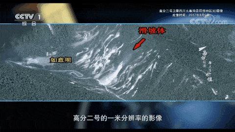
On August 8, 2017, Jiuzhaigou earthquake, my country already had many high -scoring satellites in the rail. On August 9, a high -scoring number 2 -meter resolution image was distributed to all relevant units in the morning. The results of the disaster situation, including the damage of houses, the hindrance of the road, and even the affected situation of the scenic area, avoiding greater losses.
When a major disaster comes, the relevant personnel are in the National Space Administration's Emergency Decision and Data Center's Emergency Decision and Command Hall in the National Aerospace Administration to coordinate the domestic remote sensing satellite data to support the disaster situation.
In addition, within one hour of the disaster, the high -orbit satellite data should be distributed to relevant units for disaster research and guidance.
This mechanism was a fight against the 2008 Wenchuan earthquake. Aerospace people have done it!
Liao Chujiang said: "The high score special benefits the people and serves the people's livelihood. In this process, we also realize our value of life."
When the high -scoring project proposed the development goals, Academician Wang Xiji, then the leader of the expert group, proposed that everyone should make everyone as conveniently to obtain high score data as electricity. To this day, our astronauts can say it.
In addition to sharing data in China, we also attach great importance to the international cooperation and international promotion of high -scoring satellite data.We have signed more than 150 aerospace cooperation agreements with 50 countries and international organizations.It reflects that we are a big country for the community of human destiny. It is the pursuit of high score spirit and the pursuit of life value.In the show, the host Sabenin asked Liao Chujiang's question: "What is the biggest enjoyment in life?"
"The greatest enjoyment of life is to create social value and realize life value in a great cause," Liao Chujiang answered.
Source | CCTV
Edit | Wang Shuying Li Nan Liu Yan Zhou Xinyue
- END -
Help the company's "three -degree window" in the administrative approval of the Luzhou Market Supervision Bureau's administrative examination and approval work is well received

On July 27, Sichuan Jiji Pharmaceutical Co., Ltd. sent Jinqi to the Luzhou Market ...
The "addition and subtraction method" ingenious vaccination vaccination "Formula"

Ganjiakou Street/Photo ConstructionIn order to further improve the awareness of va...