Typhoon "Plum Blossom" may land from the coast of Qingdao on the evening of the 15th in the early morning of the 16th on the 16th.
Author:Poster news Time:2022.09.15
Volkswagen Network • Poster Journalist Liang Wen Jinan Report
At 16:50 on September 15th, the Meteorological Services of the Shandong Provincial Meteorological Observatory reported that the typhoon "Plum Blossom" will land from the coast of Qingdao around the early morning of the 16th. On the night of the 15th, there will be heavy rainfall in Shandong. There are strong winds in each sea area and inland.
Typhoon No. 12 this year "Plum Blossom" (tropical storm) at 16:00 on the 15th is located on the south of the Yellow Sea, about 120 kilometers in the direction of Lianyungang City, Jiangsu Province. It is expected that "plum blossoms" will move north at a speed of 15 to 20 kilometers per hour. The center will enter Shandong from the coast of Qingdao around the early morning of the 16th. After passing through the Shandong Peninsula, it will move into the Bohai Strait from near Penglai on the morning of the 16th, and on the morning of the 16th, and Gradually transgender is temperate cyclone.
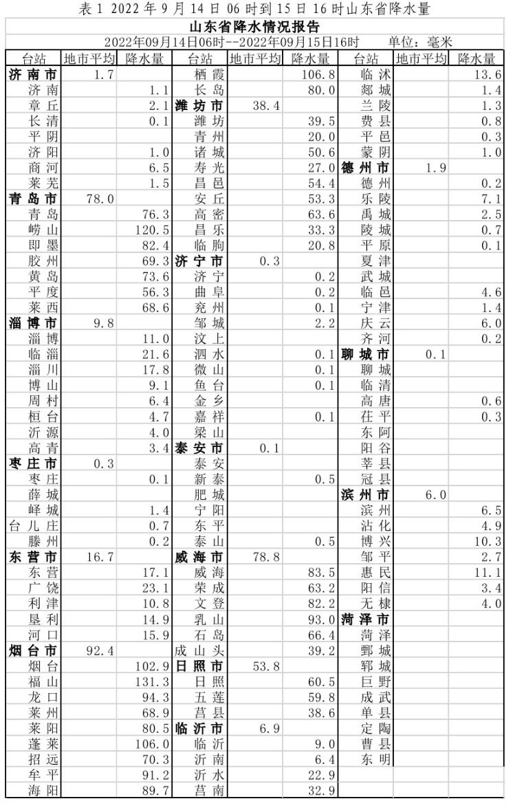
Affected by "plum blossoms", from 6:00 on the 14th to 16:00, there were 97 counties (districts and cities) and 1300 towns in Shandong Province. The average precipitation was 24.4 (mm, the same below), and the amount of water was about 3.83 billion cubic meters. The average cities: Yantai 92.4, Weihai 78.8, Qingdao 78.0, Rizhao 53.8, Weifang 38.4, Dongying 16.7, Zibo 9.8, Linyi 6.9, Binzhou 6.0, Texas 1.9, Jinan 1.7, less than 1 or precipitation without precipitation. There are 1 stations exceeding 200.0, 11 of 150.0 ~ 200.0, 60 from 100.0 ~ 150.0, and 370 of 50.0 to 100.0. Qingdao Bihai Lantian 182.1.
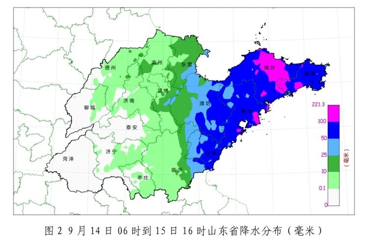
The current radar precipitation echo is mainly located in Weifang, Linyi, Rizhao, Peninsula, and the middle of the Yellow Sea, and the Bohai Strait.
From 14-15, level 7 to 8 gusts appeared in the middle of the Yellow Sea 9 to 10 Northeast winds, and the largest level 10 (27.3 meters/s) in Nanda Island in Qingdao; 6-7 gusts 8 gusts of level 6-7 gusts in the Bohai Sea, Bohai Strait and the north of the Yellow Sea appeared. Grade Northeast Wind.
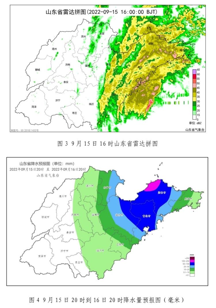
It is expected that on the night of the 15th, Qingdao, Yantai and East Weifang will have a heavy rainstorm (40-80 mm local 100-150 mm), Weihai, Dongying, Zibo, Weifang west, and Rizhao local heavy rain or heavy rain (10-20 20-20 There are small rain in Binzhou, eastern Jinan, eastern Jinan, and Linyi in eastern Jinan; during the day of the day, the weather in Dongying, Weifang and Peninsula are cloudy, and the weather in other areas turns cloudy.
On the night of the 15th, the southeast wind in the middle of the Yellow Sea turned southwest wind 8-9 gusts 11-12, and the Bohai and Bohai Straits northeast winds of 7-8 gusts from levels of 7 to 10 gusts to level 8-9 gusts 11-12, north of the Yellow Sea, northern Yellow Sea Southeast wind level 8 gusts 9-10; during the day of the 16th, the northeast wind of the Bohai Strait weakened at level 11-12 gusts to level 7 gusts 8-9, and the Grade 11-12 gusts of the northeast wind of the Bohai Sea weakened By level 5-6, the northern part of the Yellow Sea weakens at level 8 to 10 gusts at level 8 to 10 gusts, and the middle of the South Wind 8th Gust of the middle of the Yellow Sea is 9-10 to the north wind 5-6. From the night of the 15th to the day of the day, the 5-6 gusts of the northeast wind of Rizhao and the northeast wind of the Peninsula region will turn to level 7 to 10 gusts at level 7 to 4 to 4 to 4. Grade enhancement to level 6 to 7 gusts 8-9 to Nanfeng 3, and the level 4 to 5 gusts of north winds in other areas weaken to level 3.
Typhoon Miao Bai, No. 13 this year, was transformed into temperate cyclones in the Northwest Pacific Ocean surface on the afternoon of the 15th.
Typhoon No. 14 this year "Nanda Metropolis" (Typhoon Grade) On the 15th, the center was located on the Pacific Ocean, about 1320 kilometers northwest of Guam in the United States, and the largest wind of the largest wind near the center. It is expected that "Nanma Du" will move north to north at a rate of 15 to 20 kilometers per hour, and the intensity will gradually increase. The maximum is likely to move from the southern part of the Korean Peninsula to the northeast on the 19th. Affected by the "Nanma Metropolis" and cold air, there will be obvious windy weather from the sea area in Shandong on 18-19.
"Nanma Metropolis" is far from Shandong Province. The later path and the impact on Shandong are still uncertain. The meteorological department will closely monitor the changes in weather, strengthen tracking and judgment, and scroll time to release forecast early warning information.
- END -
The School of Energy and Machinery Engineering, Shanghai Electric Power University, has achieved a series of important results in the field of solar photovoltaic thermal use
Recently, Associate Professor Zhang Tao of the School of Energy and Machinery Engineering of Shanghai Electric Power University uses the first author and communication authors' academic papers Prelim...
[New Era of Endering New Journal] New Era of Jian Gong] Shifo Town, Maiji District: "July Chrysanthemum" blooms "getting rich flowers"

Editor's note: Li Li has opened a new journey, and he does not neglect the future....