Typhoon's strange "position", who said it?
Author:China Meteorology Time:2022.09.16

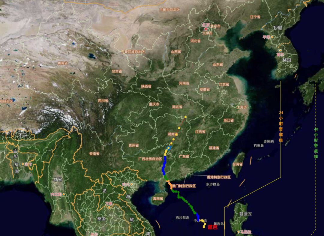
Around 20:30 on September 14th, Typhoon "Plum Blossom" this this this was the coast of Putuo, Putuo, Zhoushan, Zhejiang Province. But its early path uncertainty was great. Earlier, Typhoon Xuanlan Nuo No. 11 this year also came out of the unique "V" path.
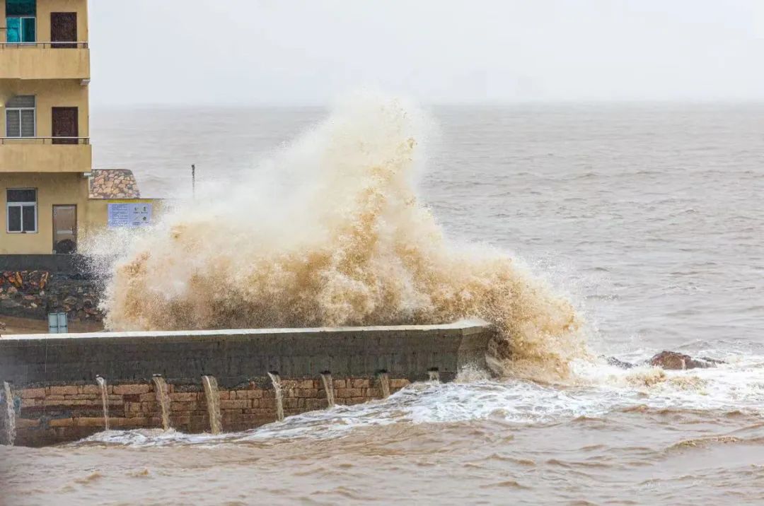
Around 20:30 on September 14th, Typhoon Plum Blossom, No. 12 this this this this this was the coast of Putuo, Putuo, Zhoushan City, Zhejiang Province.
Every year, the typhoon season, the landing point, and the influence of wind and rain have become the focus of people's attention. Back, rapid turn, eastward movement, south ... Why did typhoons appear these "wonderful" positions?
Why does "plum blossom" slowly swallow
Guide the airflow, stay away from the secondary height, and multi -vortex restraint
On September 14, Typhoon Plum No. 12 this year landed on the coast of Putuo, Putuo, Zhoushan, Zhejiang Province. Later, he passed through Hangzhou Bay at 0:30 am on the 15th and landed in Fengxian in Shanghai in Shanghai. After entering Jiangsu, he continued to the north.
From September 14th, the fast -moving weather satellite rapid imaging instrument cloud map can be seen that the typhoon "plum blossoms" organizational structure is symmetrical, the eye area is clear, and the core area is strong. It is the strongest typhoon that has landed in my country since September 15 this year.
Data show that from 1949 to 2021, the average life expectancy of the tropical cyclone (from the beginning to the disappearance) was about 6 days, and the "plum blossoms" moved slowly on the sea for a week since September 8th. Day landed in Fengxian in Shanghai and continued to go north. Typhoon "Kanu", which is similar to its path in 2005, completed a lifetime of generating -landing -dying in a week.
Introduction of Dong Lin, chief forecast at the Central Meteorological Observatory:
""
The weak air current is the main factor that caused the "plum blossom" to move slowly before landing. At present, "plum blossoms" are a bit far away from the subtropical high pressure, resulting in weak guidance airflow. In other words, guiding airflow's traction effect on "plum blossoms" is not strong. In addition, the restraint of the east vortex is also an important factor.
"
On September 14th, Typhoon No. 14 this year, "Nanda Metropolis" (tropical storm level), Typhoon Miao Bai (Typhoon Grade) and "Plum Blossoms" formed three dances. In addition, "Nanma Du" also indirectly transported water energy for "plum blossoms" and restrained the "plum blossom" to move west, which also caused the "plum blossom" to slow down.
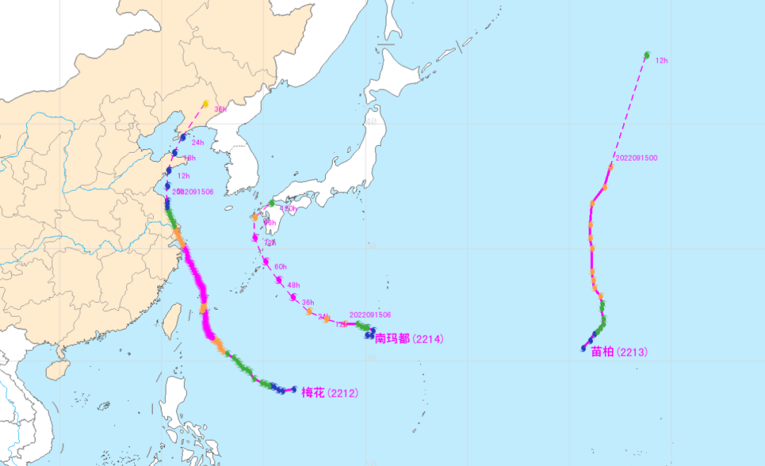
"Plum Blossoms", "Miao Bai" and "Nanma Metropolis" dance, affected by the "Nanma capital", the "plum blossom" moves slowly
According to the forecast, the "plum blossoms" coincided with the tide of astronomy. The combination of the two will bring at least three days of storms to East China. In the future, it will also affect Shandong and parts of the northeast. The power cannot be underestimated.
The similar "Kanu" also coincides with the astronomical tide to land in Zhejiang, bringing wind and rain and economic losses to Zhejiang, Fujian, Shanghai, Jiangsu and other places.
Experts remind that the eastern coastal areas need to prevent the influence of crazy wind and heavy rain, while doing a good job of water storage of the reservoir while preventing the adverse effects of heavy precipitation and strong wind.
Where does the typhoon go?
Subjective high pressure, monsoon groove, cold air
Multi -system effects such as West Wind Tanks and other systems
Regardless of whether it is rules or a strange position, the typhoon from birth to demise life, there are "noble people" who lead the way, "tigers" with road blocking, and "teammates" love and kill each other. In the end, each typhoon has a unique personality. Essence
All in all, due to its own structure and subtropical high -voltage, monsoon grooves, South Asian high -voltage, cold air, western wind groove systems, and multi -air rotary interactions, the typhoon cannot go freely. In the end, for the typhoon path, the biggest impact is the external environmental factors. As soon as the typhoon was born, it was "involuntary."
The subtropical high pressure (auxiliary high) can be said to be an old friend who loves and hates. When the typhoon is on the south side of the deputy high, the typhoon and the deputy high will form a strong east wind. Under the guidance of the east air, the typhoon travels west or northwest. If the vice is stable, the typhoon may be more "obedient". However, the actual situation is often not the case. The deputy Gao Dong retreats, Xishang, north, and south, and breaks, mergers, etc. will correspond to the position of typhoon.
Let's take a look at the typhoon path of "Qi Qi"
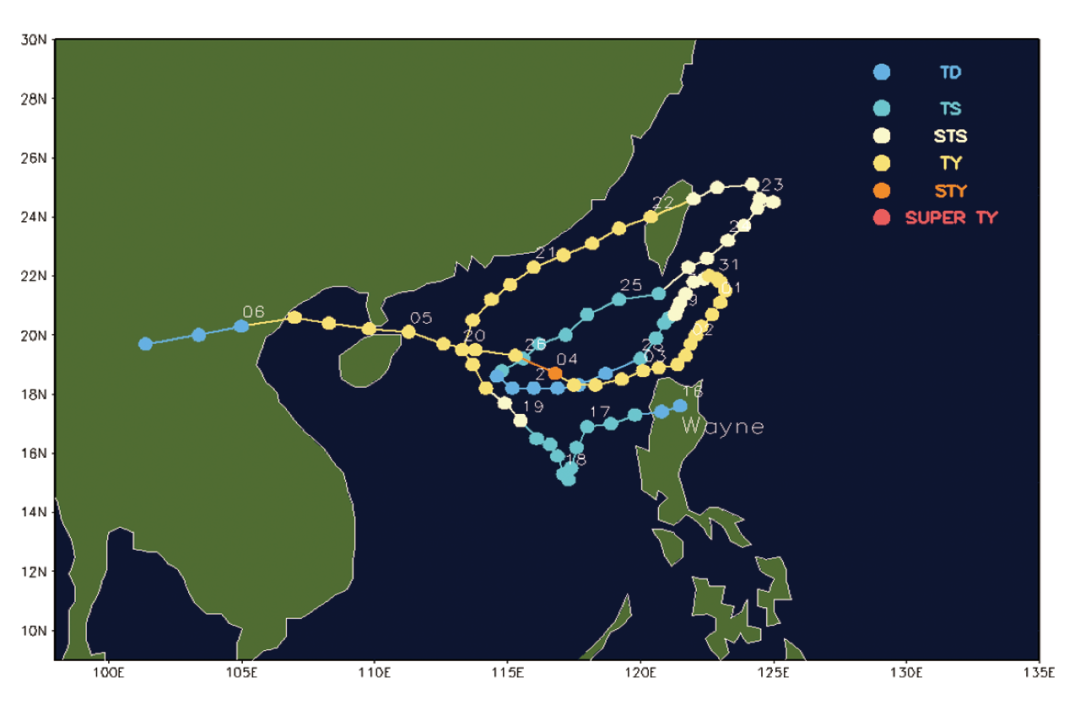
Typhoon "Wayne" path map No. 16 1986
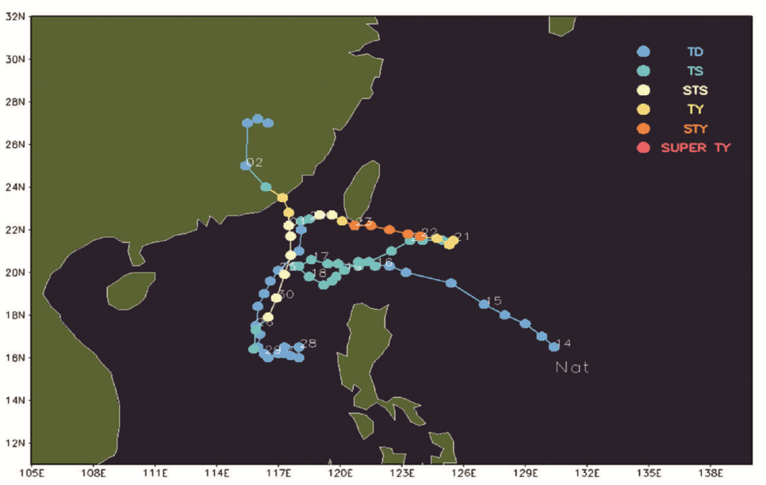
Typhoon 1991 Typhoon "Beat" path map
Take the typhoon "Xuan Lannuo" as an example. In the early stage, due to the influence of its northern side -like high -shaped high, "Xuan Lannuo" stabilized westward. After walking to Taiwan and the east, the secondary high was broken into two stages, which made "Xuan Lannuo" a bit "six gods". After waiting for the deputy high to adjust the vice -high side with the east side of Taiwan, it was turned north to the north, and the "V" step was stepped out of it.
The monsoon groove system can achieve both typhoons or typhoons. Typhoon No. 2 this year, 10 days before the generation of the generation, the scattered cloud group in the monsoon groove was chaotic near the Philippines, bringing long rainfall. Until April 10, a strong cloud group in the monsoon groove was numbered as typhoon "catfish". Although there is an independent "title", "catfish" has always been unable to get rid of the mother's body, but has been dragging the long monsoon tail. In the end, it has not grown into a strong typhoon. Essence
However, this does not mean that its power is insufficient. Its powerful sprinkler function still causes major losses to the Philippines. In addition, the typhoon generated in the monsoon groove, in addition to under the guidance of the southwest monsoon itself, has a rare east movement path in the typhoon, the overall north -south swing of the monsoon groove will also cause the typhoon path to suddenly change. If the trend of the monsoon groove is not accurate, it will cause the prediction deviation of the typhoon path. For example, the typhoon "Lu Bi" No. 9 2021 will have a deviation in the forecast of Fujian. In addition to the sub -high and low layers of the middle layer of the stream layer, the high pressure of South Asia with the high -rise layer of the flow layer will also affect the typhoon path, making the typhoon move more complicated and confusing. On June 30, Typhoon Siaba, No. 3 this year, was generated in the central part of the South China Sea. From the perspective of the early forecast field, the middle layer of the "Siam" is a saddle -shaped field to guide the weak airflow; the low -level circulation shows that the typhoon on the east of "Avey" has developed, and there may be a double typhoon effect. "Barn" north side has high -pressure spine blocking. These factors are not conducive to "Siaba" to move north. Many models forecast are mainly west.
Typhoon No. 3 "Siam" Siam "Path Picture
However, with the continuous adjustment of the situation, especially on July 2, the original forecast South Asia high -pressure ridge line broke, forming two anti -air rings flow, leaving a passage for "Siaba" to the north. The residual clouds went north until the Bohai Sea did not slowly dissipate. There are huge differences in the prediction of the "Siaba" before and after the path forecast. Although there are many factors, the form of high pressure in the south pressure is the most important reason.
Cold air may be the "enemy" that typhoon does not want to meet in a lifetime. Cold air mostly appears in spring and autumn. Because the autumn typhoon is more active than spring, cold air has a greater impact on autumn typhoons. Suddenly low -rise cold air may weaken the typhoon's opposite cloud system, and even completely dispersed the typhoon, which may cause its path to suddenly adjust to the south. Even if the typhoon cannot be completely eliminated, the typhoon may "damage the soldiers" and weaken the energy. Typhoon "Aisani" in 2020 was not weak, but when he entered the South China Sea, he met with a strong cold air after meeting a strong cold air and the path fell south, and was eventually eliminated in South China.
After the cold air goes south to low latitudes, it is difficult to portray the temperature field and temperature change field, and the strength of the cold air and whether it can invade the typhoon's kernel area is also a necessary basis for judging its impact on the typhoon. At present, due to the lack of effective diagnostic products, the time and degree of cold air on typhoons are still difficult problems in typhoon business forecast.
In addition, the impact of cold air on typhoons is also very interesting, sometimes it will cause cracks on the wall of the typhoon, invading the core area of the typhoon from the crack. This is the most worried issue of the forecasm -because the closing of the typhoon eye wall is the most important basis for the currently relying on satellite cloud maps to make typhoons. Once the typhoon eyes are destroyed and cannot be closed, the typhoon cannot be set to a strong level; but at this time, the typhoon eyes that are not broken at the core area of the typhoon are still strong, which is easy to cause the typhoon intensity. Sometimes, in front of the cold air, the typhoon will "cleverly" keep the integrity in the way of shrinking the eye area. Cold air cuts off the spiral cloud outside the core area of the typhoon like scissors. The strength changes are not great.
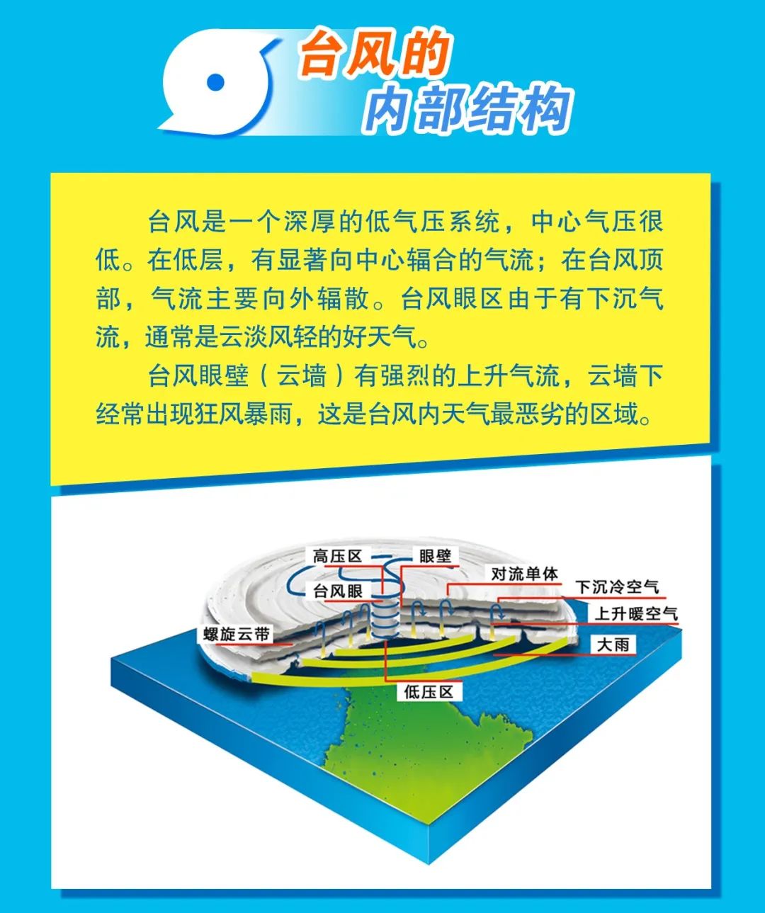
Typhoon internal structure
Mid -latitude west wind groove is also an important role that affects the path of typhoon. Typhoon Bayway, No. 8 in 2020, Typhoon Masak and No. 10 Typhoon "Sea God" is three typhoons that combine north and west wind grooves. Due to the abnormal stability of the situation, the three typhoons have a path to the north. After the typhoon enters the Northeast region, it is combined with the west wind grooves. It gradually becomes a green cyclone, which has a great impact on the northeast region.
The interaction between the vortex system is more like a palace fight, which has the most direct and obvious impact on the typhoon path. In recent years, the frequency of the pool rotation system has become higher and higher, and the typhoon has switched between the active period and the interval period. During the active period of typhoon, two, three, or even four typhoons have been generated one after another. The vortex system affects each other, and the spin may affect the direction of other typhoons indirectly to indirectly affect the sub -high position and movement. Influenced by the pooring, the first forecast path and intensity were extremely difficult to generate when the "Xuan Lannuo" was generated.
In short, whether it is a conventional path or a strange path, each typhoon cannot be only affected by one system. On the contrary, under the common action of multi -system, the typhoon becomes unpredictable and elusive, bringing great challenges to the forecast work
The Chinese Meteorological News Agency produced
Author: China Meteorological News Reporter Jian Jufang Edit:
- END -
The list of the third batch of electric bicycle bicycles in our county is here
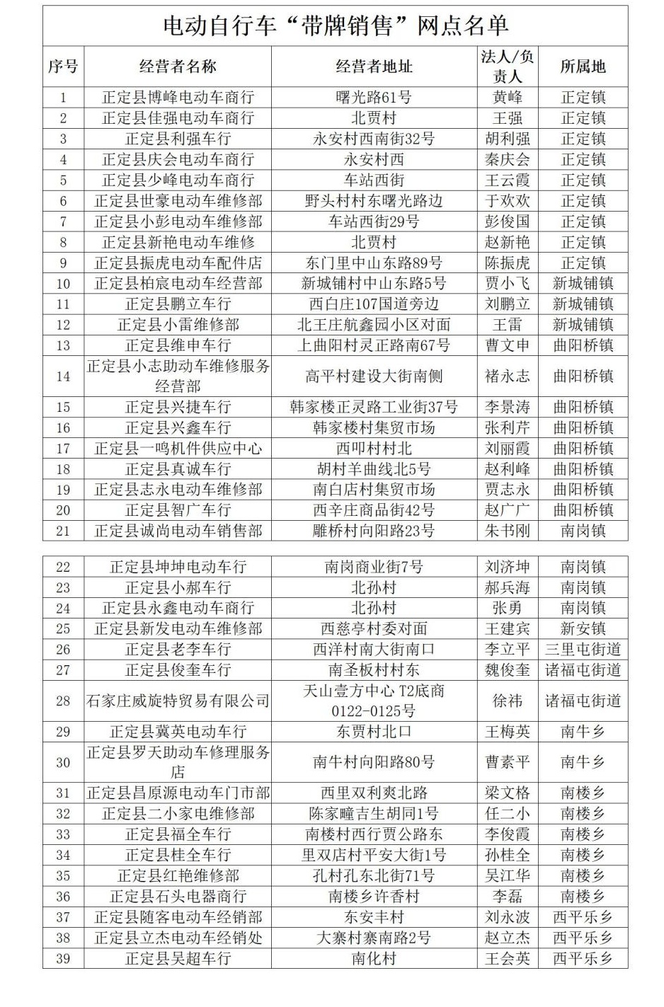
Zhengding CountyList of electric bicycles with card sales outlets(The third batch)...
GDP increased by 4.2% year -on -year Shaanxi's economy in the first half of the year

On July 20, the Shaanxi Provincial Government News Office held a press conference ...