The latest path chart of "Nanma" is here!Will it affect Hangzhou?There are new news in autumn
Author:Voice of Zhejiang Time:2022.09.16
Source: China Weather Network, Hangzhou Weather
The copyright belongs to the original author, if there is any infringement, please contact it in time
Typhoon "Plum Blossom" Sandon Shandong Qingdao
Tonight will also be available in Liaoning
Typhoon "Plum Blossoms" landed on the coast of Laoshan District, Qingdao, Shandong, in Laoshan District, Shandong, the latest typhoon in Shandong in the coast of Laoshan District, Qingdao, Shandong.
Earlier, "Plum Blossoms" landed at 20:30 on the 14th at the coast of Putuo, Zhoushan, Zhoushan, Zhejiang, and then landed on the coast of Fengxian in Shanghai before 0:30 in the morning of the 15th. Strong typhoon.
According to the monitoring of the Central Meteorological Observatory, Around the 16th, the center of the "plum blossom" landed on the coast of Laoshan District, Qingdao, Shandong. When landing, the strength was a tropical storm. The latest typhoon in Shandong since 1949.

Yesterday, Qingdao, Shandong, encountered heavy rainfall, and the water accumulated was serious
Under the influence of typhoons, Jiangsu, Shandong and other places encountered strong wind and rain. Monitoring shows that from 8:00 yesterday to 6:00 today, large rainstorms in the northeast of Jiangsu, central Shandong, eastern Liaoning, southeastern Jilin, and other areas. ~ 150 mm), Shandong Qingdao and Yantai Bureau Extraordinary Rainstorm (250-353 mm). In addition, 8-9 gusts are also appeared in eastern Jiangsu, Shandong Peninsula and other places, and levels 10-12.
At 5 o'clock today, the "Plum Blossom" center is located in Laiyang, Yantai, Shandong. It is expected that "Plum Blossom" will move north at a speed of 20-25 kilometers per hour. The strength will not change much. In the evening, it will land again in the Liaoning Lushun to the Zhuanghe area (tropical storm level, 18-23 meters/s, level 8-9), and then gradually transgender into temperate cyclones.
The latest path chart of Typhoon "Nanma" is here
There are new news in Hangzhou autumn
The impact of the typhoon "plum blossom" on my country has not ended, and a Typhoon No. 14 "Nanda Metropolis" was here on the sea. Today (16th) it is strengthened from typhoon to strong typhoons. From the cloud map, the typhoon eyes are clear and huge, and it will be strengthened to super typhoons in the future.

Fortunately, its path is east, and after turning gorgeous at sea, he will go straight to Japan. It is nearly a thousand kilometers away from Hangzhou at the same latitude (18th). Therefore, for Hangzhou, only the northeast airflow that will be affected by its peripherals will occur in the eastern region will occur in the eastern region tomorrow morning, and that's all.
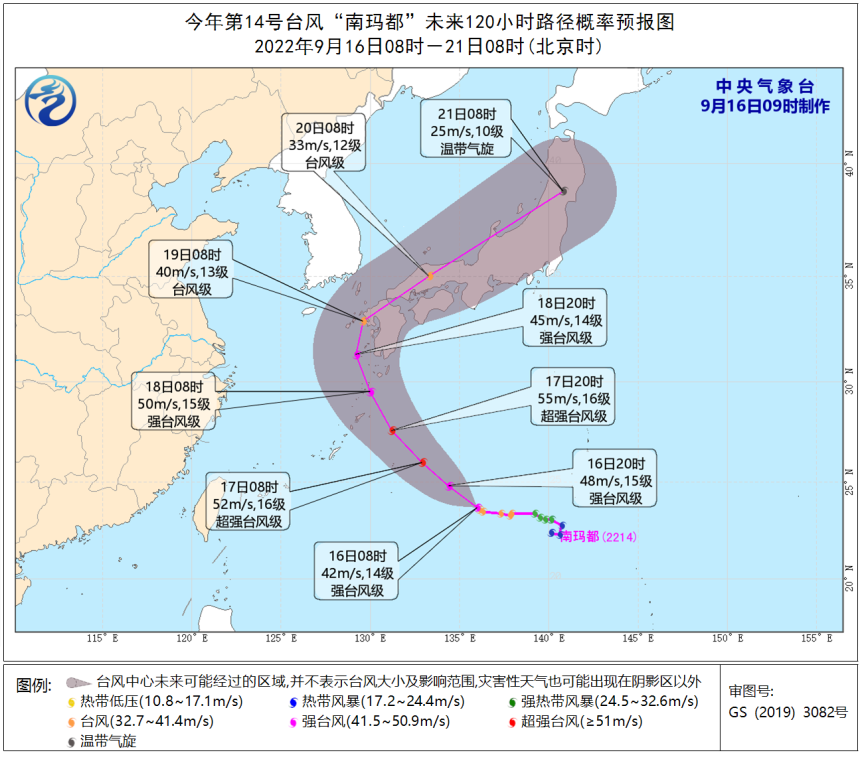
To say that it has a greater impact on Hangzhou, or a cold air southward on the 19th, only carrying the wind and without rain, cooling is the theme. After it arrived, from the 20th, the lowest temperature in the urban area would drop to 16 and 7 degrees, which will also be the first time in the second half of this year to fall to less than 20 degrees. This cold air will undoubtedly accelerate the pace of Hangzhou autumn, and everyone's expectation is not far away.
- END -
Kaihai!Thousands of sails are full of fish and shrimp full cabin

Authoritative Express News 丨 From July, these new people's livelihood rules have begun implementation
Hot JulyA batch of relationships you and my new rules have begun to implementClari...