Maybe four to my country, what kind of typhoon "Plum Blossom" IV
Author:Jinan Times Time:2022.09.17
Typhoon "Plum Blossoms" on the 12th of this year was fierce and landed twice in Zhejiang and Shanghai overnight.
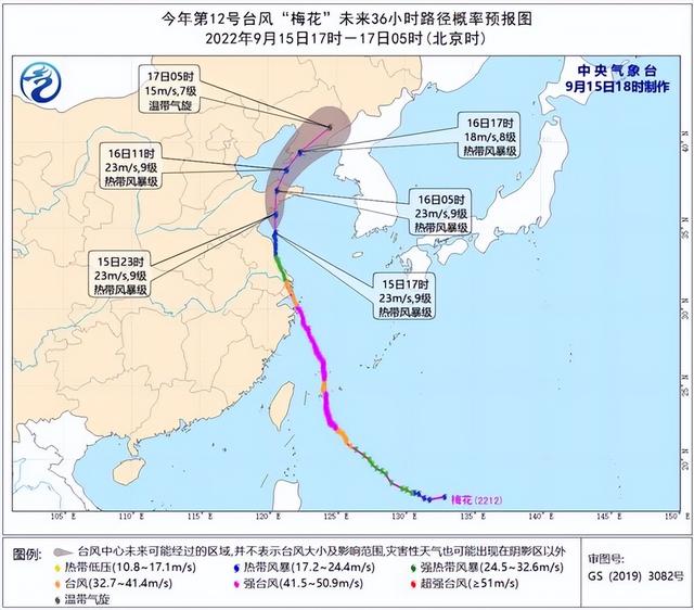
Typhoon "Plum Blossom" mobile path. Central Meteorological Observatory made at 18:00 on September 15th
It has not only become the strongest typhoon that has landed in my country this year, but also the strongest typhoon in Zhoushan and Shanghai, Zhejiang since 1949.
The people of the free shipping area are no stranger to its previous life, that is, "Plum Blossom" II in 2011. At that time, "Plum Blossom" also pointed directly at the East China region. Although the three -degree appointment and did not eventually land in my country, it still had a significant impact on the Yangtze River Delta region.
In contrast, this year's "Plum Blossom" IV was refreshing and came straight to the long triangle. What is powerful is that after the "plum open", the ring is still huge, and it will be in Shandong, and may even be in Liaoning. What kind of typhoon is "Mei Four"?
Fierce
On the morning of September 8th, Typhoon Plum Blossom, No. 12 this year. At the beginning of birth, it was regarded as a strong player, but the path was still uncertain.
"Plum Blossoms" stabilized at the sea and became stronger step by step. In the early morning of September 11, it was strengthened to a strong typhoon level, and the typhoon eyes were clearly visible. On the same day, its path was obviously westward. As it gradually approached, the possibility of landing in East China was getting greater.
However, on September 12, the "plum blossom" moved slowly, and the deep cold water flipped, which weakened the intensity. At the same time, Typhoon No. 13 "Miao Bai" suddenly generated. Although it is in the deep Pacific Ocean in the northwest, it has no impact on our country, but its generation has undoubtedly increased the complexity of the maritime plot.
In the early morning of September 13, "Plum Blossom" moved into the warm southern seas of the East China Sea, and re -enhanced it into a strong typhoon level at 5 o'clock in the morning. At this time, its goal is more clear, and speed up to the "Free Shipping District". At this time, the "plum blossoms" are menacing. Although they are not big, they have "Big eyes of Kazilan".
The typhoon did not arrive, and the wind and rain went first. Affected by the combination of the typhoon body, the inverted and cold air north side of the typhoon, the obvious rainfall began on September 12.
According to statistics from the Central Meteorological Observatory, since September 12, the cumulative rainfall of the central Zhejiang, Shanghai, southeast of Jiangsu, and northern Taiwan Island has 50-150 mm. Millimeter, 542 to 592 mm in Shangyu and Puzhou in Shaoxing in Zhejiang; 7-8 gusts of 7-8 coastal coastal coastal coastal coastal coasts, southeast of Jiangsu, southeast of Shanghai, southeast of Shanghai, southeast of Shanghai, southeast of Shanghai, southeast of Jiangsu. Ren 12 to 15.
Wherever you go, the wind is heavy and heavy. Around 20:30 pm on September 14th, in the eyes of the public, the "plum blossom" landed on the coast of Putuo, Zhoushan, Zhejiang. When landing, the maximum wind near the center was 14 levels, which was a strong typhoon. "Plum Blossom" became the first typhoon to land in East China this year, and its intensity far exceeded the top three typhoons that landed in my country this year.
Subsequently, it accelerated the pace and sneaked into Shanghai late at night. On September 15th, he landed again on the coast of Fengxian around the coast of Fengxian on September 15th again, refreshing the historical record again -the strongest typhoon to land in Shanghai since 1949.
It took two and a half hours to run for more than 80 kilometers. The "Plum Blossom" center across Shanghai from the southeast to the northwest, and left elegantly on the morning of September 15.
Although the "plum blossom" has weakened to a strong tropical storm at this time, its circulation form is still complete, and the pressure is still to Jiangsu, Shandong, Liaoning, and Jilin.
Past and Present
Generally speaking, the typhoon will be injured after landing, but why is the "plum blossom" so individual, can it continue to go deep into the inland after landing?
"Mainly benefited from the time and location." Hu Xiao, chief meteorological analyst of China Weather Network, analyzed that the "plum blossom" has a strong strength. When the first landing is, it is a strong typhoon level. At the same time, it goes north along the coastline of the East China area. Half of the main structure is still on the sea, so it is continuously transporting the water vapor at the sea to the land while walking. After landing, the water vapor is still sufficient. Not only that, it also has a younger brother to cheer. Typhoon No. 14 "Nanma" is located on the east side of the "Plum Blossom", using the "Southeast Wind" to transport water vapor.
It seems that behind a powerful typhoon is the help of many factors.
For the people of the free shipping area, the last "plum blossom" can be traced back to 2011. Due to the use of typhoon names, this year's typhoon "Plum Blossom" is strictly "plum blossom" 4, and the "plum blossom" in 2011 is "plum blossom" II.
The Central Meteorological Observatory said that the "Mei II" at that time also reached the intensity of super typhoons. It also pointed out that the nickname "Mei Chaofeng" was sent directly. At that time, the sea was also very lively, and the three dances danced, so the prediction of the path of "plum blossoms" caused the forecasters to lose a lot of hair.
At the time, the "Mei II" would land in Zhejiang, Shandong, and Liaoning in China, but it made a three -degree appointment and chose to go north of my country to the north of China. Finally, it landed in North Korea, also known as "plum blossoms."
This year's "plum blossoms" aimed at the East China region, but the short knife went straight. It was not enough after the "plum opened twice".
The Central Meteorological Observatory mentioned that "Mei IV" still has the memory of "Mei II". It looks like and like a path. The landing location is more than the last time.
Following "Plum Blossom", Typhoon Miao Bai, No. 13 this year, was born on September 12. Compared with the "plum blossom" and "Miao Bai" in 2011, the standing position was re -engraved. Especially "Miaobai", the birthplace of 2011 and 2022 is super close. As for "Mei I" and "Mei III", there are no traces in the history of typhoon. "Mei One" was born in the winter of 2004, and there was nothing to do. "Mei III" was the first typhoon in 2017, and it was not born at the moment.
Compared to "Plum Blossom" One Two Three, the strength of "Plum Blossom" IV is really prominent.
"Plum Blossom" may be ascended to my country
For Shanghai, two autumn typhoons ushered in in ten days, and they were not a good role.
Looking back at Typhoon Xuan Lannuo No. 11 this year, the moment the northwestern Pacific "Wind King" was born, it has not been unusual.
Han Ning, chief service officer of the Shanghai Meteorological Bureau, introduced that only 36 hours since the report, "Xuan Lannuo" has been upgraded from a tropical storm to a super typhoon level. Very rare. And its trend is very complicated. After different stages of different stages, it shows the peculiar direction of "V -shaped".
"Xuanlan Nuo" after annexation of tropical low pressure became huge and full of wings, with a diameter of about 1,000 kilometers. Later, it crossed the latitude on the sea of more than 300 kilometers from Shanghai, and eventually landed on the southern coast of South Korea. The peripheral circulation was "throwing" to Shanghai.
In contrast, the growth of "plum blossoms" is quite satisfactory, and it is much smaller. Although it is lower than the intensity of "Xuan Lannuo", it has zero -distance contact with Shanghai. In particular, Shanghai is on the right side of its direction. The overall wind and rain it brings to Shanghai is much stronger than "Xuan Lannuo".
Judging from the absolute path, "Plum Blossom" found a friend -the typhoon "Fireworks" in 2021. Both have landed in Zhoushan for the first time and landed in the free shipping area. It has a significant impact on the Yangtze River Delta region.
The two of the Shanghai Meteorological Bureau found that "fireworks" is a full chronic child. "Fireworks" was generated at 2:00 on July 18, 2021, and it took 7 days on the sea. After landing in Putuo, Zhoushan, I wandered over the night in Hangzhou Bay and refused to move. The next morning, I landed twice in Pinghu, Zhejiang Province the next morning. The first landing was about 21 hours.
As a result, the wind and rain brought to Shanghai for a long time to Shanghai. In terms of rainfall, "fireworks" pressured "plum blossoms".
"Plum Blossoms" was fierce. Although it was stuck in high -pressure tropical high -pressure on the east and west rings at the sea, and moved slowly, it began to speed up when it was near the coast of East China.
In terms of landing intensity, "Plum Blossom" is still better, which refreshes the record of "Fireworks" when landing on Zhoushan. When the "Fireworks" landed, the maximum wind near the center was 13 levels, and "Plum Blossoms" had level 14 at the time of landing. At the time of the second landing, there were still 12 levels. Since 1949, the strongest typhoon in Zhoushan and Shanghai in Zhejiang.
Both "fireworks" and "plum blossoms" have stubborn life. The history of "fireworks" is 13 days, which is more than twice the average life expectancy of typhoons. It is selected as one of the top ten weather and climate events in China in 2021. "Plum Blossom" has completed the second login, but the structure is still complete and the circulation is still huge. After landing for about 15 hours, a strong tropical storm level is maintained.
According to the news of the Central Meteorological Observatory on September 15th, the "Plum Blossom" is currently on the southern sea of the Yellow Sea. It will be available again in the area of Huangdao, Shandong to Haiyang at night (September 15th) at night (tropical storm, 18-23 meters /Second, level 8-9), and will be moved into the Bohai Strait in the morning (September 16) in the morning (September 16), and will be available again in the coast of Liaoning to the Zhuanghe area around Liaoning to Liaoning. Level 8-9), then gradually became a green cyclone.
China Weather Network said that if "plum blossoms" landed in Liaoning, it will be the latest typhoon in the northeast (except for the typhoon that had previously affected the Northeast); and it was the third typhoon in my country in 1950, and for the first time With the four boards such as "Zhejiang-Shanghai-Shandong-Liaoning".
In this case, "plum blossoms" can also be regarded as a miracle of typhoon life.
(Source: Surging News)
Edit: Han Luying
- END -
A toothpaste is 128 yuan. Is the high -priced toothpaste really worth it?

Jimu Journalist Kang XuyangIntern Zhao PenggeThe toothpaste market is moving towar...
Danger!70 -year -old people do not listen to the persuasion of the wild swimming daughter to call the police for help
Recently, Ms. Liu, Suzhou, called the police that her father did not listen to per...