The clouds are occasionally sprinkled with rainy during the cloudy period, and these common sense should be kept in mind!
Author:Sichuan Provincial Meteorologi Time:2022.09.17

17
Saturday
September 2022
In the 22nd Bailu solar terms in the lunar calendar

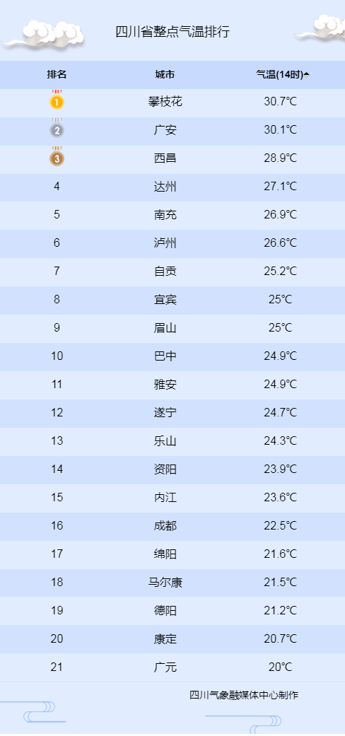
At 14:00, the temperature is active
The sky was overcast in the morning, and rainfall appeared in some places. In the afternoon, the situation in the sky was not great, and there was a dispersion of light rain at night. The overall temperature was not high, and the body sensation was cool.
Weather forecast in the next 24 hours
Tonight: Ya'an, Leshan, Yibin, Zigong, Neijiang, Zijiang, Ziyang, and Guang'an 7 cities have shower in cloudy days. Or thunderstorms.
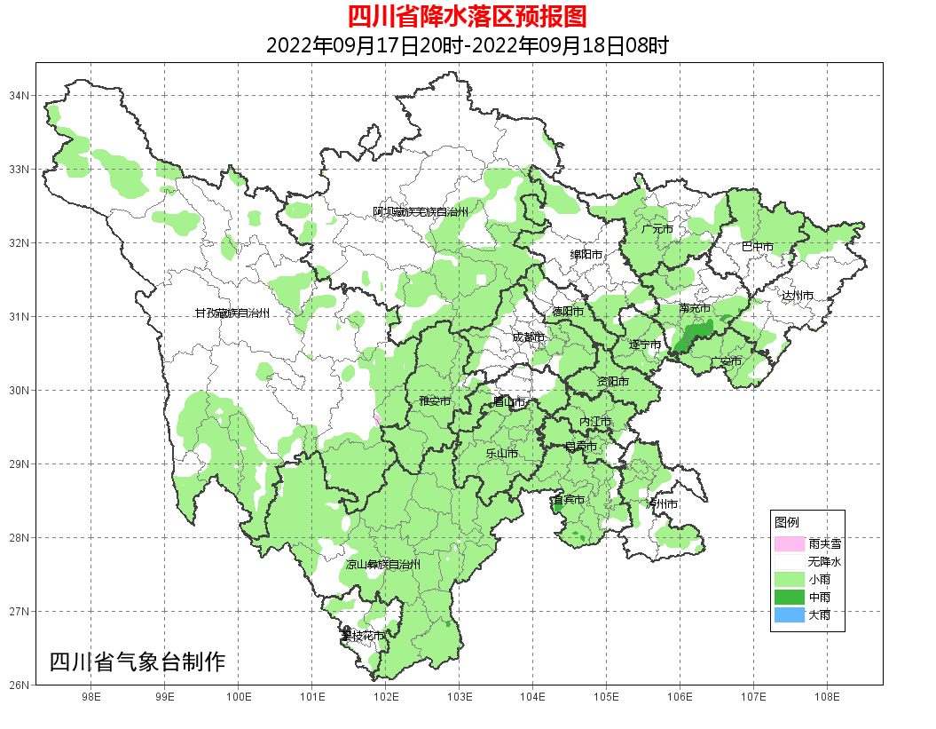
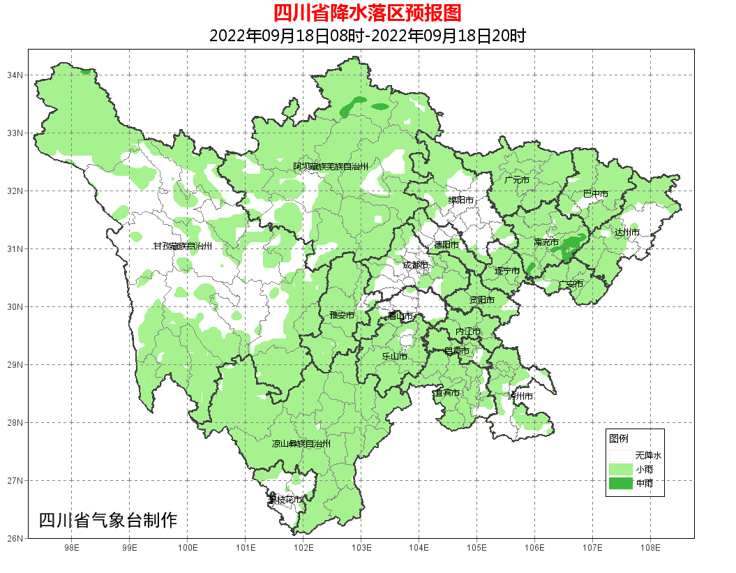
Tomorrow during the day: Most of the basins of the basin have scattered shower; the clouds of clouds in the western Sichuan Plateau and West West has decentralized showers or thunderstorms.
Within 24 hours, the lowest temperature in the basin: 20 ~ 23 ° C; the highest temperature: 25 ~ 28 ° C in the west, and the rest of the place 28 ~ 31 ° C.
National Weather Trends
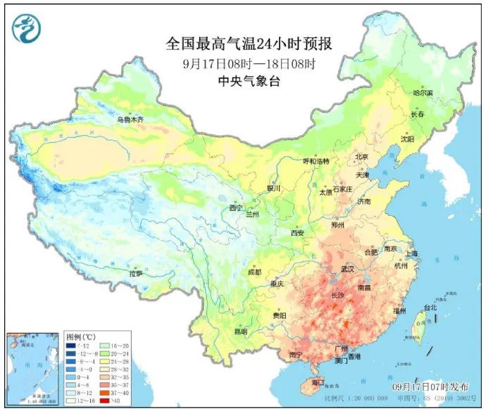
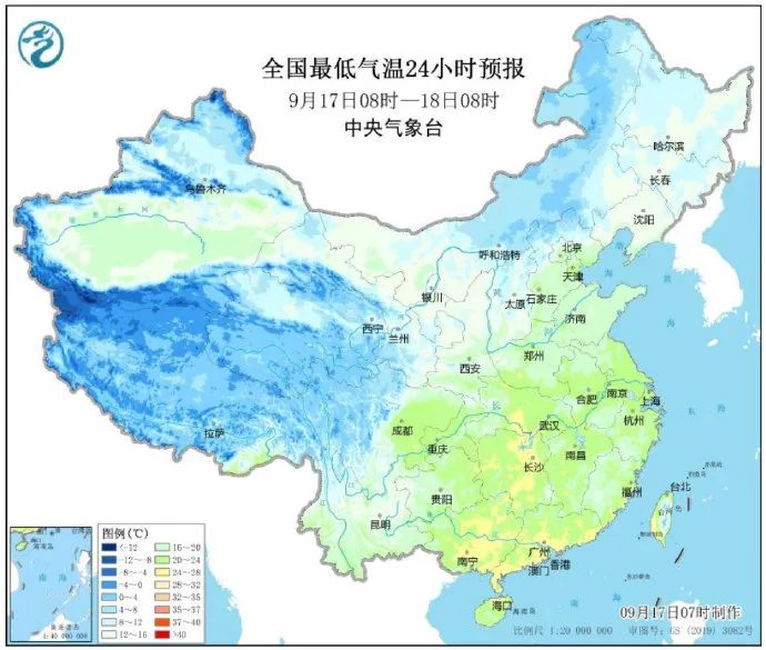
According to@Meteorological Observatory
Key weather forecast
1. Key weather in China
(1) There is a precipitation process in the eastern and southwest of the northwest region
(2) Typhoon "Nanma Du" will affect the East my country Sea of China
Typhoon "Plum Blossom" this year was transformed into temperate cyclones in the northeast of Liaoning on the night of the 16th. The impact on my country has ended.
Typhoon No. 14 this year's "Nanda Metropolis" (Super Typhoon Level) is located on the northwestern Pacific Ocean about 850 kilometers east of Kyushu Island, Japan at 05 on the 17th. The maximum wind nearby level 17 (58 meters/s). It is expected that "Nanma Du" will move northwest at a speed of about 20 kilometers per hour, and gradually approach the coast of the southwest of Kyushu Island, Japan. It may be moved into the East China Sea on the 18th. Movement, the intensity gradually weakened. Affected by the "Nanma Metropolis" and the peripheral circulation, from 08:00 on the 17th to 08:00 on the 18th, there are 7-8 large winds in the central and eastern parts of the East China Sea, with a gust of 9 to 11, and the wind power of the east of the eastern part of the East China Sea can reach level 10 to 12 , Local can reach level 13 to 16, and gusts 17.
2. Key weather abroad
(1) There are strong precipitation in South Europe and other places in Ganges Plain
(2) West Asia North Africa and other places continue to be high temperature
Specific forecast in the next three days
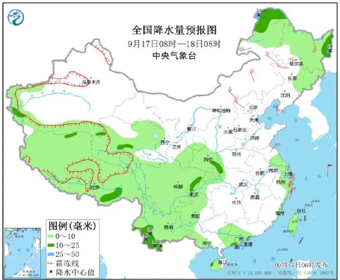
From 08:00 on September 17th to 08:00 on the 18th, there were heavy rain in parts of the northeast of Inner Mongolia, northwestern Heilongjiang and northeast, southwestern Yunnan, and eastern Sichuan Basin. The central and eastern parts of Inner Mongolia, most of the Heilongjiang, Liaodong Peninsula, northwest of Hebei, and eastern Zhejiang have 4-6 levels, and gusts 7. The northern and southern waters of the East China Sea will have 7-9 and 10 gusts.
From 08:00 on September 18th to 08:00 on the 19th, there are central to heavy rain in northern Tibet, southern Qinghai, central Gansu, central and southern Ningxia, western Shaanxi, and central Sichuan Basin. Among them, the central and southern parts of Sichuan Basin There are heavy rains (50-60 mm). The central and eastern Inner Mongolia, most Heilongjiang, western Jilin, Liaoning, Shandong Peninsula, southern Jiangsu, eastern Zhejiang and other areas have 4 to 6 winds and 7 gusts. The northeast of the northeast of the northeast of the northeast of the northeast of the northeast of the East China Sea will turn westwest wind. The central and southern west of the East China Sea will have 7-8 and gust -9 levels.
From 08:00 on September 19th to 08:00 on the 20th, the southwest of Inner Mongolia, the northwest of North China, the eastern part of the Northwest, the northern Sichuan Plateau, the majority of Sichuan Basin, southwestern Yunnan, western South China, southern, and northern Hainan Island and other areas There are heavy rain. Among them, there are heavy rains (50-90 mm) in southern Shaanxi, southwestern and northern parts of the Sichuan Basin. The central and eastern parts of Inner Mongolia, the majority of Heilongjiang, the majority of Liaoning, the Shandong Peninsula, the southeast of Jiangsu, and the eastern part of Zhejiang have levels of 4 to 5 winds and 7 gusts. The northern part of the East China Sea will have 11-12 levels and grades 13 levels of west wind. Most of the Yellow Sea, the Bohai Sea, and the Bohai Strait waters will have 7-8 and gust -9 levels.
Influence and attention
1. The obvious wind and adverse effects brought by the typhoon "Nanma Metropolis" to the Eastern Sea on 17-19;
2. 17-20 Cold air affects the northern region, paying attention to the unfavorable impact of wind cooling weather;
3. There are many precipitation in the Southwest and the south of Shaanxi and Gansu. There is a strong rainfall process on the 18th to the 20th.
4. Pay attention to the development trend of meteorological and drought in Jianghuai, Jiangnan and other places.
5. Autumn harvest autumn meteorological service.
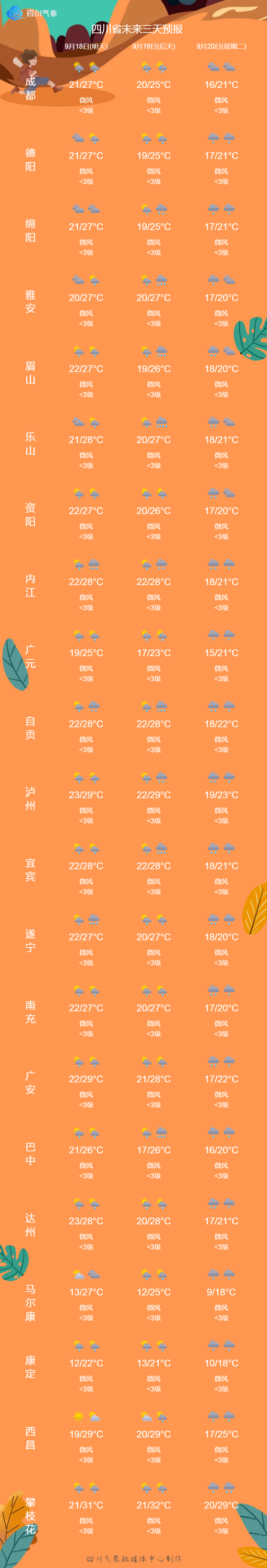
Urban forecast for the next three days
In the autumn fire period, these common sense must be kept in mind!
There are many windy weather in autumn, less precipitation, dry and dry, and it is easy to cause fire. What precautions do you know about family fire prevention, autumn harvest fire, forest fire prevention? Poke the picture to understand#说 说#


Click to read the original text to learn more about meteorological information
- END -
Volunteer service "not snoring" helps the construction of civilized cities

On August 6th, looking at the lit light bulbs, the left -behind elder Wang, the le...
Yanbian Workers Cultural Palace project enters the equipment debugging stage

On July 14, the reporter saw in the Yanbian Workers' Cultural Palace that the staf...