Cold air brings 1 character temperature!The impact of Typhoon "Nanma" on Zhejiang is manifested in ...
Author:Published by Zhejiang Time:2022.09.18
These two days
The weather in Zhejiang is really good
The temperature in the late summer is getting more and more pleasing to the eye
but
Cold air calls you long sleeves next week

At present, Bai Lu's solar terms are daily, but the temperature of the three -character head during the day is still regular. If the cold is not defensive, there will be high temperature emerge. The temperature difference between the morning and evening increases, and everyone needs to adjust the clothes in a timely manner.
In this season, the "Autumn Tiger" is indeed waiting for the opportunity, but you don't have to worry about it next week! In the next 7 days, Zhejiang is dominated by cloudy weather. Since the 20th, it will be affected by cold air, and the temperature will decline.
With the influence of weak and cold air penetration, the coolness of the morning and evening next week is even more rich. The temperature of the 1 -character head emerges. Although there is heating during the day, the highest temperature in many places also debuted at the highest temperature.
In short, this time the cold air performance is quite good. It is only responsible for cooling and not carrying wind and rain. Most of the good weather in Zhejiang is accompanied.
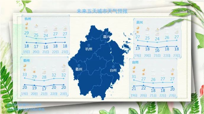
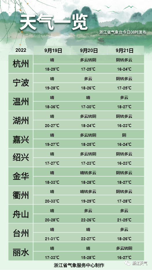
Zhejiang weather in the next three days
The weather trend in the later period
22-25
The province is cloudy.
26th
There are sometimes shower in southern Zhejiang and coastal areas, and other areas are cloudy to overcast.
27th
There are sometimes shower in the province.
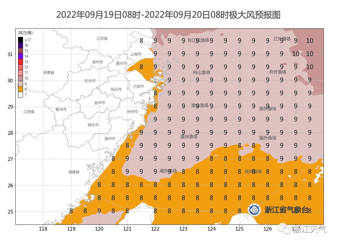
Typhoon "Nanma Metropolis"
After the autumn typhoon was pushed, at present, the typhoon of the sea event is only Typhoon No. 14 this year "Nanda Metropolis" (strong typhoon level). It is 31.1 degrees north latitude, 130.7 degrees east longitude, 15 levels (48 meters/s) near the center, and the lowest air pressure of the center is 930 Hill.
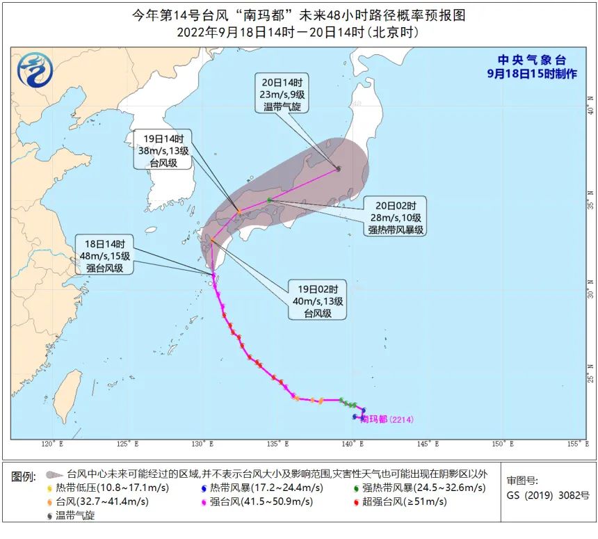
Looking at this path, "Nanma" will not land in my country. The impact on Zhejiang is mainly manifested in the coastal wind.
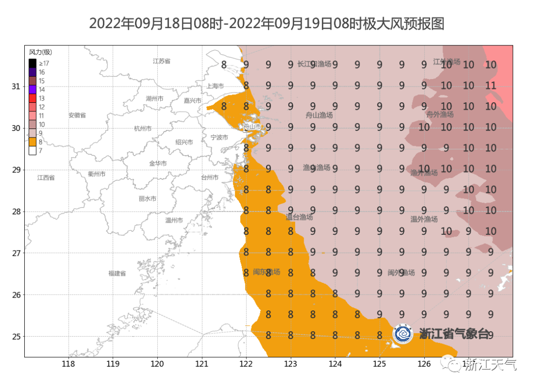
Georgian forecast
Today, the coast of the north of the Ming and Zhejiang
Ge'm 8-9 level
Especially reminded
All kinds of ships that have just been caught in the sea
Need to pay attention to the weather movement
Pay attention to sailing safety
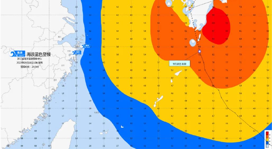
Wave alert
The Zhejiang Marine Monitoring and Forecast Center issued a wave blue alert at 10:00 on the 18th based on the "Emergency Plan for the Marine Disaster". Affected by the outer and cold air of Typhoon "Nanda Metropolis", it is expected to be noon today to noon tomorrow:
Near -sea waters: Hangzhou Bay has a middle wave of 1.4 meters to 2.2 meters; there are large waves from 3.5 meters to 5.0 meters in northern Zhejiang; in central Zhejiang, there are large waves from 3.5 meters to 4.5 meters in the south.
Near -shore waters: Zhoushan and Ningbo are from 2.0 meters to 3.0 meters. Near -shore sea wave early warning level is blue.
Comprehensive from Zhejiang Weather, Central Meteorological Observatory, Zhejiang Natural Resources Department, Zhejiang Provincial Marine Monitoring and Forecast Center, etc.
Lear editor: Ren Jiani
Editor in charge: Shen Bo
- END -
Akskao County Meteorological Observatory lifted lightning yellow warning [Class III/heavier]
Aktao County Meteorological Observatory lifted the thunderbolt warning issued at 17:21 on June 8, 2022 at 10:02 on June 9, 2022.
Qingdao Old Cadre Activity Center holds the vocal training course for veteran cadre art troupes

In order to improve the overall art level of the veteran cadre art troupe and enha...