Notice!Typhoon "Nanma" influence!Ge Gust level 9!Weifang cools down!
Author:Weifang Media Network Official Time:2022.09.19
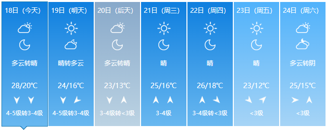
next week
Cold air coming
Temperature starts to fall
The lowest temperature on Friday 12 ℃
The wind also followed!
Affected by Typhoon "Nanma Du"
Shandong Meteorological Bureau and Weifang Meteorological Observatory
They all issued emergency warning!
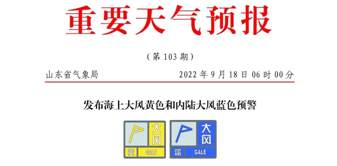
At 06:00 on September 18th, the Shandong Provincial Meteorological Observatory issued the sea wind yellow and inland wind blue warning at sea: Affected by Typhoon No. 14 "Nanda Metropolis" and cold air. The Bohai, Bohai Strait, northern and middle of the Yellow Sea and the central parts of 5-6 are enhanced to level 7 gusts 8-9, and Binzhou, Dongying, Weifang, Rizhao and Peninsula areas 3-4 are enhanced to level 4-5 gusts 6-7. Others Level 3-4 inland areas; night from the night of the 18th to the 19th, the Northeast Wind, the Bohai Strait, the northern part of the Yellow Sea and the central part of the 7-10 gusts 9-10, the Bohai Sea 7 Gust 8-9, Weihai 6 — Grade 8-10 levels, Binzhou, Dongying, Weifang, Yantai, Qingdao, and Rizhao level 5-6 gusts 7-8, and level 4 gusts 5-6 in other inland areas; The northern and central level 7-10 gusts 9-10 weaken to level 6-7 gusts 8, the level 7 of the Bohai Strait level 7-9 weakens to level 5-6, and the Bohai Sea 6-7 gust -8 level 8 weakens to 5— Level 6, Weihai level 6-17 gusts 8-10 weaken to level 4-5 gusts 6, Yantai, Qingdao and Rizhao level 4-5 gusts 6-7 weaken to level 3-4, other inland areas 3 — level 4.

Weifang Meteorological Observatory, September 18, 2022, at 08.43, issued a big wind blue warning signal: Affected by the circulation and cold air of the periphery of Typhoon No. 14 "Nanda Metropolis". The wind is large, level 5-6 gusts of grades in the inland areas, 7-8 gusts, level 7 gusts in the northern sea area 8-9, please pay attention to prevention. Defense guidelines: 1. Government and relevant departments do a good job of preventing heavy winds in accordance with their duties; 2. Turn off doors and windows to strengthen the buildings that are easily blown by the wind, such as the fence, scaffolding, billboards, etc. Items, covering construction materials; 3. Active measures to take active response measures in related water operations and past ships, such as returning to Hong Kong to avoid wind or bypassing, etc.; 4. Pedestrians should ride bicycles as little as possible. Do not go on billboards and temporary buildings when winding winding. Wait for staying below; 5. Relevant departments and units pay attention to fire prevention of forests and grasslands. Weifang's specific weather forecast is day -to -night. The weather is cloudy and cloudy. On the 19th to night, the weather was sunny, and the north winds were weakened to level 3 to 4, the lowest temperature was 16 ° C, and the maximum temperature was 24 ° C. On the 20th to night, the weather turns clear, the north wind turns to the south wind of 3 to 4, the lowest temperature is 13 ° C, and the maximum temperature is 23 ° C. Finally, I will remind you that the temperature difference between day and night is greater recently. Pay attention to the cold and warm. Remember to add and subtract clothes at any time ~ Source: Weifang Meteorological Observatory, Volkswagen Daily, etc.
- END -
Special Supervision and Inspection of Menglian County, Pu'er City
From December to July of the following year, we are the sugar press season. During the supervision and inspection, the relevant person in charge introduced to the disciplinary inspection and supervis
Summer "Sanxiangxiang" ground -ground village rejuvenation adds vitality

Classmates, welcome to Tongliang Village, Jiangnan District. In the past few days,...