This is a soil medical examination report!East -west lake soil map is online, soil fertility is checked at any time
Author:Changjiang Daily Time:2022.09.23
The Yangtze River Daily Da Wuhan Client September 23 (Reporter Cai Xinxing Correspondent Li Jia) A soil electronic map, after logging in through the terminal, you can check the nutritional content of the cultivated land soil at any time, thereby guiding farmers to fertilize scientifically. On September 23, Wuhan City was held online in the Harmony Festival of the Chinese Farmers in the cloud in 2022. At the event site, a standardized information display platform for cultivated land soil in the East and West Lake District was released.
This soil electronic map currently supports web version and Android version of APP login. The reporter of the Yangtze River Daily registered account and logged in to the platform. After seeing that the map of the west lake was divided into different blocks by different colors, there were dense and dark small circles distributed. The reporter randomly opened one of the dots in the five teams of Hebaohu and No. 158, and immediately appeared in the pH value, acid and alkali rating of this plot, nitrogen, recommended phosphorus, potassium recommended, recommended planting varieties, etc. information.
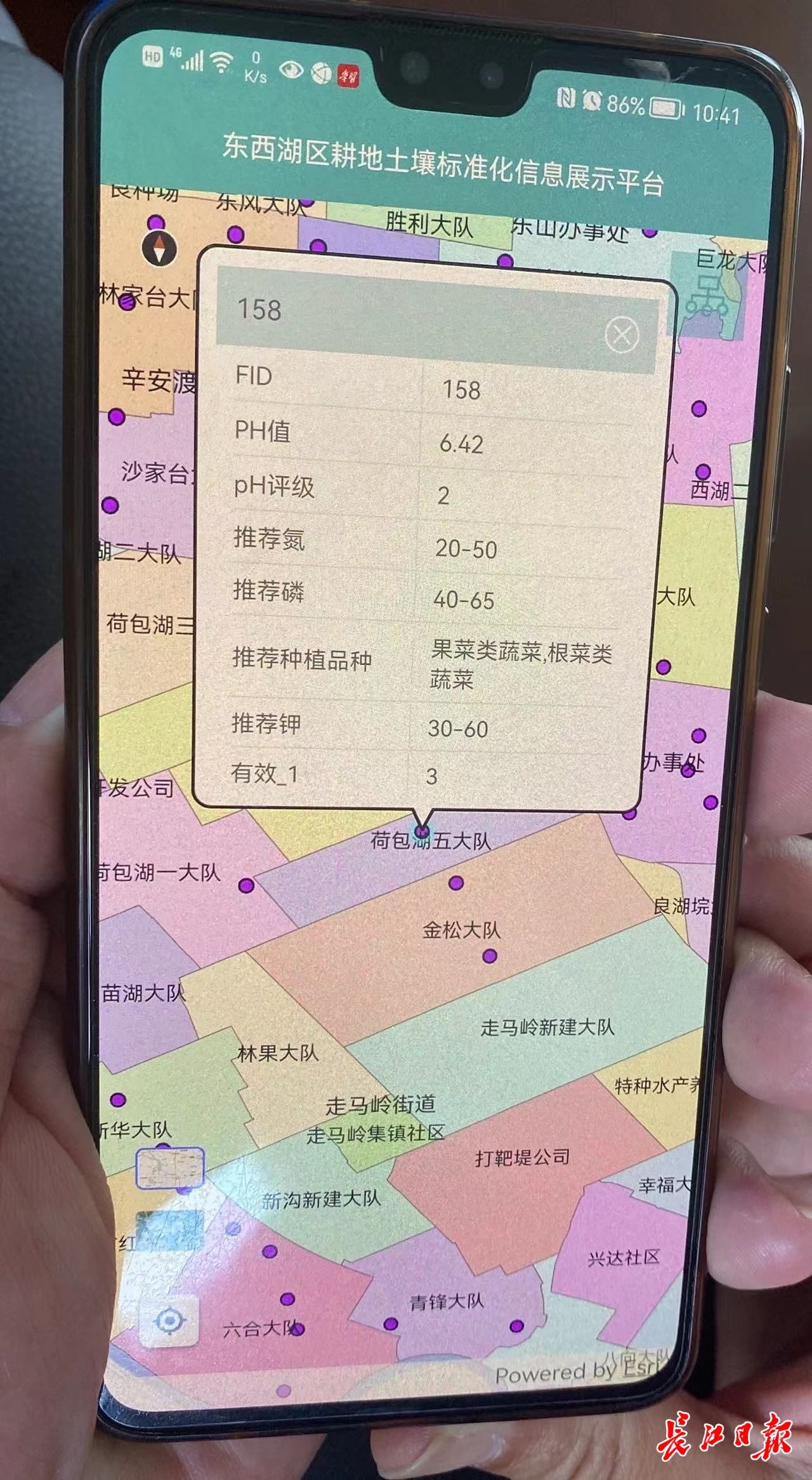
East -west lake soil map. Reporter Cai Xinxing Photo
"These data information reflects the soil fertility of a certain plot, and tells farmers how to regulate fertilizer, what is suitable for planting, and realize scientific planting." The relevant person in charge of the Agricultural and Rural Bureau of the East and Lake District introduced that at the beginning of this year, the bureau and Hubei and Hubei Hubei and Hubei. The Provincial Academy of Agricultural Sciences has cooperated on the drawing of soil maps, depending on the soil information data accumulated for many years. This soil map has collected the basic data of 180,000 mu of cultivated land in the region, and Evaluate, analyze the integration of library.
Dr. Yi Tian from the Institute of Agricultural Quality Standards and Testing Technology of the Academy of Agricultural Sciences of Hubei Province participated in the entire process of soil map drawing. She told reporters that recommendation of nitrogen and phosphorus represents the nutritional value of soil within this value. For data such as effective phosphorus, it represents the nutritional value that soil can absorb. Through the pH value and grade, farmers can know how to adjust soil pH, and soil maps will also give the most suitable crop recommendation in this area. "It can be seen through big data that the cultivated soil of the East and West Lake is suitable for planting vegetables, which is also consistent with the actual cultivation."
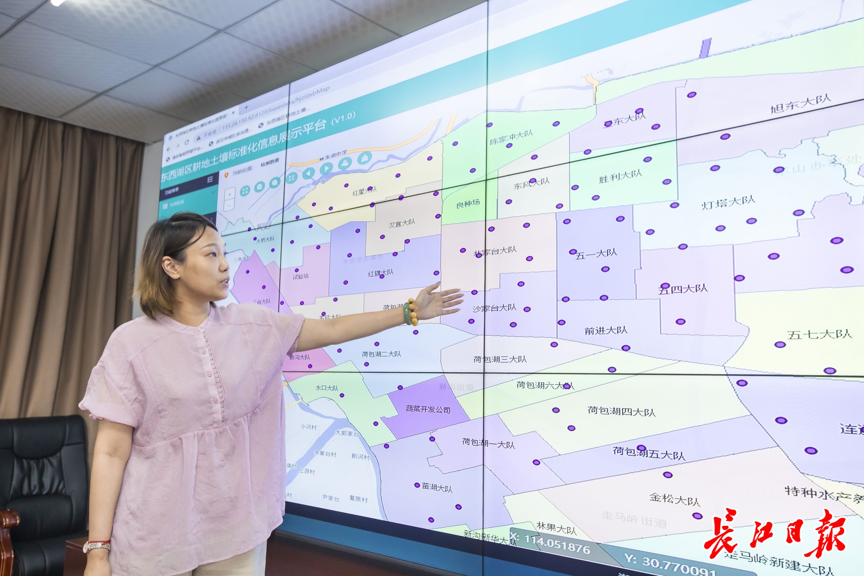
Dr. Yi Tian is introducing the soil map of the East and West Lake. Reporter Guo Chuan Photo
Although the current point is 200, the actual collection data is far more than that. Yi Tian said that in general, at least one sampling point is every thousand acres, but some plots are distributed in multiple brigades or have actual needs, and the sampling point will be more dense. These sampling information will be updated uninterrupted every year.
Every time the soil sampling, the doctoral service team of Yi Tian will first go to the scene to sample in accordance with the national sampling standards and requirements. After the collection is completed, return to the laboratory and then monitor the organic matter, pH value, and various nutritional factors of the soil sample. So as to get first -hand soil sample information. "The sampling work does not begin to draw soil maps this year. Previously, the Hubei Academy of Agricultural Sciences and the East and West Lake District cooperated for ten years. Every year, it was collecting soil information collection. With this big data as the foundation, the information platform can go smoothly. Go online, really let big data help farmers solve problems. "
How can farmers adjust after understanding soil fertility? According to the relevant person in charge of the Agricultural and Rural Bureau of the East and West Lake District, the drawing of soil maps is a front -end work. "It's like getting a physical examination report for the soil." Thanks to maintaining close contact with the team of experts for a long time, they will continue to hire these teams to conduct one -to -one guidance to farmers, based on the recommended amount of fertilization and combined with the crops planted for fertilization.
On the same day, the "Intelligent Diagnostic Platform" of the East and West Lake was also launched together. The platform can achieve remote diagnosis of crop disease and insect pest control. Farmers uploaded to the APP through the characteristics of pests and insect pests. The background can achieve remote diagnosis and prescribing medicine.
According to reports, in recent years, East and West Lake has vigorously implemented the strategy of rural revitalization, relying on science and technology to promote farming, built the first batch of smart agricultural bases in Hubei Province, and launched the "Yangtze River Bancel", "Soil Map", "Agricultural Products Investment Supervision", "Smart Diagnosis" The platform, and 12 doctoral practice bases, 3 "industry -university -research push" bases to build an agricultural intelligent building.
【Edit: Zhao Ke】
For more exciting content, please download the "Da Wuhan" client in the major application markets.
- END -
The technology is self -reliant, and there is a genetic ︱ in Wuhan to read the Yangtze River in China along the Yangtze River

The Yangtze River Daily Da Wuhan client July 21st Science and technology has self ...
Wuhu Breakfast will handle feedback!(61st)
In order to further optimize the business environment, make full use of breakfast ...