Typhoon "Olysu" has been generated!In the next week, there will be strong wind and rain in Hainan
Author:Hainan Agricultural Reclamatio Time:2022.09.23
The latest news is here
Typhoon No. 16 this year (Top Tropical Storm) (Tropical Storm) (English name: NORU; Source: South Korea; Name: 狍 今 今) It was generated on the east of the Philippines today (23) at 2 o'clock in the afternoon, 2 o'clock in the afternoon The center is located on the ocean surface of about 1150 kilometers north of Manila, Philippines, 17.7 degrees north latitude and 131.3 degrees east longitude, and the largest wind near the center is 8 (18 meters/s), and the seven -level wind circuit radius is 120 to 200 kilometers. It is expected that "Olympic" will move west at a speed of about 15 kilometers per hour, and the intensity will gradually increase, and it will enter the South China Sea on the night of the 25th.
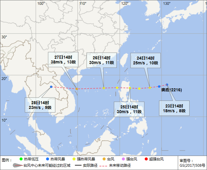
"Olysu" at 14:00 on September 23rd
Click the figure below to view the real -time path of the typhoon

What is the impact on Hainan?
What is the weather in the next few days?
Look with the daily girl
Weather forecast (September 24th to October 2nd)
Hainan Province will be continuously affected by two tropical cyclones. From September 26th, large -scale sustainable heavy precipitation weather will occur, and preliminary precipitation is expected to continue until October 2. On the night of the 25th, the typhoon "Olysu" will enter the South China Sea and move quickly in the west. On the 26th, close to the south of Hainan Island. From the 26th to 28th, it will bring strong wind and rain to Hainan Island. Tropical cyclones will be generated in the South China Sea and will bring a new round of heavy precipitation to Hainan from October 1st to 2nd.
01
Land
From September 24th to 25th, due to the influence of east to northeast airflow, there were showers or thunderstorms in most parts of Hainan Island, and the land was large to heavy rain; the highest temperature in the island was 30 to 33 ° C, and the lowest temperature was 21 to 24 ° C.
From the 26th to 28th, due to the influence of Typhoon Olympic, there were heavy rain and heavy rain in the east of Hainan Island. There were showers in the western half and heavy rain in the western half; the temperature in various places decreased slightly. In addition, the surrounding coastal land of Hainan Island is accompanied by 8-10 levels and gusts of 11-12 gusts.
From the 29th to 30th, due to the influence of the east of the east, there were heavy rain in the eastern half of Hainan Island, heavy rain to heavy rain, and heavy rain in the west half.
From October 1st to 2nd, due to the new tropical cyclone, the island has heavy rain and heavy rainstorms to extremely heavy rain; temperatures in various places have decreased slightly. In addition, land on the coast of Hainan Island is accompanied by 6-8 levels and gusts 9-11 gale.
02
Ocean
From September 24th to 25th, Hainan Island Four Weekly Sea, Beibu Gulf Sea, the sea, the sea, and the sea near the Xisha, Zhongsha, and Nansha Islands, the wind is 5 to 6, the gust of gust 7, and the gust of gusts 8 during thunderstorms.
On the day of the 26th to 28th, the Qiongzhou Strait, with a wind power of 6 to 7, and a gust of gust 8; the eastern, western and southern sea surface of Hainan Island, the sea surface of the north Bay, the sea near the Xisha Islands, the wind power of 6 to 8, and the gust -9 level; Zhongsha level; Zhongsha With the sea near the Nansha Islands, the wind is 5 to 6, the gust of gust 7, and the level 8 of the gusts during thunderstorms.
On the night of the 28th to 29th, Hainan Island's four weeks, the sea surface of the Beibu Gulf, the sea surface of the northern Bay, the sea, the Xisha, Zhongsha, and the Nansha Islands, the wind power level 5-6, the gust of gust 7, and the gust of gusts 8.
From the night of the 29th to 30th, Hainan Island's four -week sea surface, the sea surface of the Beibu Gulf, the sea surface near the Xisha and the Zhongsha Islands, the wind power of 6 to 8, and the gust of gust 9; Time Gust level 8.
From October 1st to 2nd, Hainan Island's four -week sea surface, Beibu Gulf sea surface, the sea surface of the Xisha and Zhongsha Islands, the wind is 7 to 9, and the gust of gust is 10-11; Grade, level 8 in the thunderstorm.
Warm reminder of the Meteorological Department of Hainan Province
01
Typhoon No. 16 "Olysu" moves fast. After entering the South China Sea on the 25th, it will quickly approach the offshore of the south of Hainan Province. Please pay close attention to the latest weather forecast and do a good job of returning to Hong Kong to avoid wind management in Hong Kong as soon as possible.
02
Due to the continuous heavy precipitation in the eastern half of Hainan Island and saturated soil water, a new round of precipitation will increase the risk of geological disasters, floods, and small and medium rivers.
03
Low -lying farmland needs to dredge the ditch in advance to prevent staining damage due to water accumulation. Winter melon vegetables in the eastern region can be appropriately extended to avoid the adverse effects of rainy weather.
Disclaimer: Reprinted or quoted this public account news, please indicate the source and the original author.
Source | Hainan Daily Client
Edit | Liang Ning
Editor in charge | Wu Qirong
Duty header | Zhong Ye
- END -
Hohhot City Public Security Bureau launched the second centralized unified operation of summer night public security inspections

According to the deployment of the Ministry of Public Security and the Public Secu...
Hot and hot!Xiaoyu "responded" to ...

According to the public account of the Gansu Provincial Meteorological Bureau, the...