Next week, Xiamen's temperature rises to prevent the "autumn tiger" hurt people
Author:Xiamen Daily Time:2022.09.25
In the next week, the city is mainly under the control of subtropical high -pressure. The ground layer is still the home of the Northeast wind and weak cold air. Under this situation, the weather in our city will rise and sunny and dry. Remind citizens to pay attention to replenishing water and pay attention to the safety of fire at the same time.
On the maritime side, it is expected that the super typhoon "Olysu" will land on the coast of East Vietnam from the early morning of the 28th to the morning of the morning. After landing, the intensity will be weakened rapidly. For our city, "Olympic" and cold air joined forces. Today, the city has strong coastal winds. Today, there will be 6-7 and 8-level northeast winds in the inside of our city.
In addition, Typhoon "Tallas" No. 15 this year has been transformed into a temperate cyclone on the morning of the 24th on the morning of the 24th. The Central Meteorological Observatory stopped the number at 8 am on the 24th.
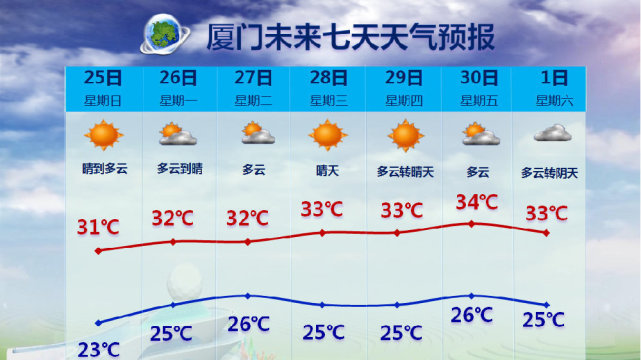
In terms of temperature, in the next few days, as the subtropical high pressure is strengthened, the temperature in our city will rise, and the highest temperature is expected to rise to 32 ° C. After the 27th, the temperature will rise, and the level of 34 ° C may be reached at the end of the month. Pay attention to preventing the "autumn tiger" hurting people, and still do a good job of heatstroke and cooling.
Xiamen Evening News reporter Wang Dongcheng Weishan
- END -
The United States has become the world's most known national diagnosis of 5,189 cumulative diagnosis

According to US media reports, the number of American acne cases has increased in ...
Baoer Diary (924)

Do not stay up late at homeGo to bed early to exerciseHold your mouthPourHappy day...