Strong Typhoon "Olysu" has entered the southwestern region of the South China Sea
Author:Global Times Time:2022.09.26
Chinanews.com, September 26. According to the website of the Central Meteorological Observatory, Typhoon "Okulu" No. 16 this year has landed on the coast of Orola in the eastern part of Luzon Island, Philippines at 8 pm yesterday (25th). The maximum wind nearby is 16 levels (55 meters/s, super typhoon), and the lowest air pressure in the center is 930 Hill. After landing, it moves north to the west. Strong typhoon level, today (26th) from Luzon Island, Philippines, moved into the sea surface of the South China Sea. At 5 o'clock in the morning, it is located on the central and eastern parts of the South China Sea in the east of Huangyan Island in the east of Huangyan Island in my country. The largest wind near the center is 14 Level (42 meters/s), the lowest air pressure in the center is 955 Hill.
From the 26th to 27th, there were many rainstorms in the southwest. There were small rain in some areas in Sichuan, Chongqing, Yunnan, Guizhou, Qinghai -Tibet Plateau and other areas, heavy rain or heavy rain; rain or snow in high altitude areas.
Strong Typhoon "Olympic Deer" has entered the South China Sea
Typhoon No. 16 this year, "Olympic" was landed in the coast of Orola in the eastern part of Luzon Island, Philippines yesterday (25th) at 8 pm yesterday (25th). Typhoon grade), the lowest air pressure in the center is 930 hundred Pache, and after landing, it moves north to the west, passing through Luzon Island, Philippines. The island moves into the sea surface of the central and eastern part of the South China Sea. At 5 o'clock in the morning, it is located on the central and eastern parts of the South China Sea, which is about 195 kilometers north of Huangyan Island in the east of Huangyan Island. Pa. It is expected that "Olympic" will move west at a speed of 25 to 30 kilometers per hour, and gradually approach the coast of eastern Vietnam. The intensity will be strengthened. At 15-16 levels, strong typhoon or super typhoon), the intensity weakened rapidly after landing. The Central Meteorological Observatory issued a typhoon yellow warning at 06:00 on September 26.
Affected by the cold air and "Olympic", from 08:00 to 08:00 on the 26th, the coast of Fujian, the coast of Guangdong, the eastern coast of Hainan Island, the western coast of Taiwan, and the Taiwan Strait, the Basta Strait, the South China Sea, and the three seas of the South China Sea, and the three waters of the South China Sea, and the three waters of the South China Sea, and the three waters of the South China Sea. There will be level 6 to 7 winds near the sea area near the sand. The wind is 13 to 16 levels, and the gusts are 17 or above; the Sansha Islands will have heavy rain or heavy rain, and some islands will have heavy rain (100-130 mm).
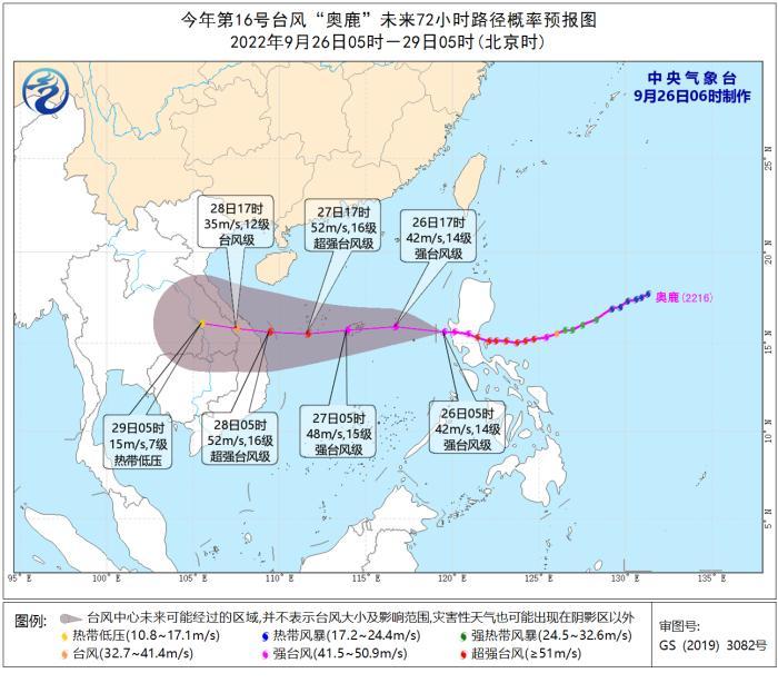
Typhoon "Olysu" path probability forecast chart in the next 72 hours
How rainy is the southwestern region
From the 26th to 27th, there were many rainstorms in the southwest. There were small rain in some areas in Sichuan, Chongqing, Yunnan, Guizhou, Qinghai -Tibet Plateau and other areas, heavy rain or heavy rain; rain or snow in high altitude areas.
Specific forecast in the next three days
From 08:00 on September 26th to 08:00 on the 27th, there are small to medium rain in Tibet, Qinghai, southern Gansu, southwestern Shaanxi, Sichuan, Chongqing, Guizhou, Yunnan, Hainan, and Taiwan. Among them, southeast of Tibet There are heavy rain in southeast Qinghai, southern Gansu, northern Sichuan Plateau, and southern Sichuan. The South China Sea will have level 11 to 12 winds and gusts 13.
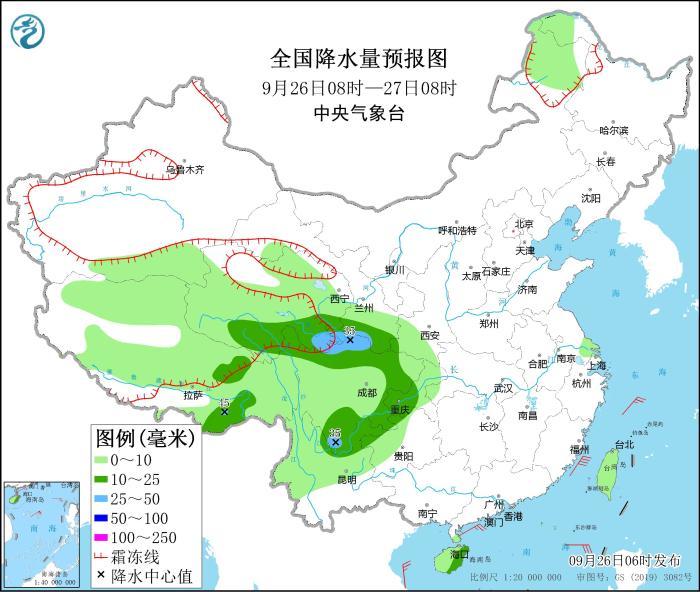
National precipitation forecast chart (September 26th to 08:00 on September 26th)
From 08:00 on September 27th to 08:00 on the 28th, there are heavy rain in southeast Tibet, southern Shaanxi, western Sichuan Plateau, Chongqing, western Guizhou, and Hainan. Among them, there are heavy rain in parts of the eastern part of Hainan Island. There are heavy rains (100 to 130 mm). The central and western seas of the South China Sea will have 12 to 14 winds and gusts 15.
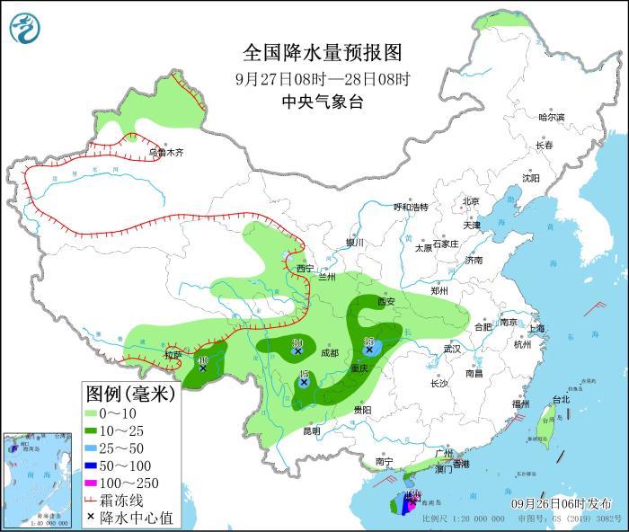
National precipitation forecast chart (September 27th to 08:00 on September 27th)
From 08:00 on September 28th to 08:00 on the 29th, there are middle to heavy rain in southeast of Tibet, southern Sichuan Plateau, northern Yunnan, southern South China coast and Hainan. There are heavy rains (50-80 mm). The central and western seas of the South China Sea will have levels of level 9 to 11 and gusts 12, and the North Bay will have level 7 to 8 and gusts 9.
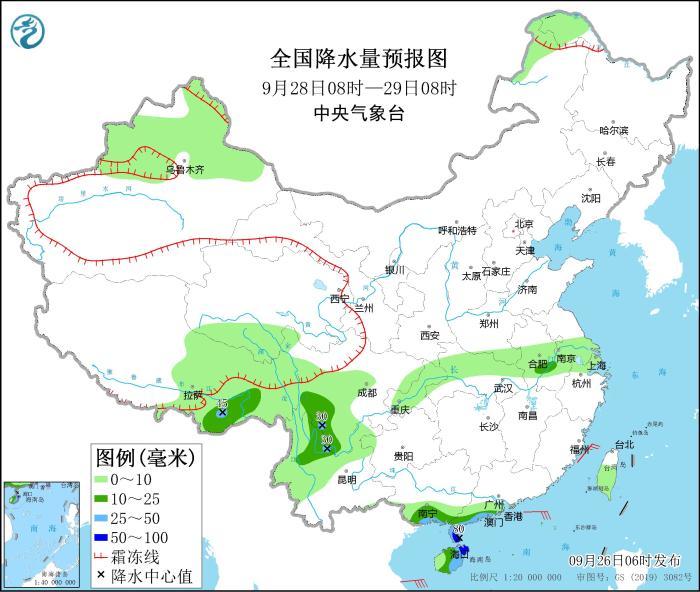
National precipitation forecast chart (September 28th to 08:00 on September 28th)
Source: China News Network
- END -
Zuo Qiang and his party went to the Northeast Region to investigate and guide

From August 1st to 2nd, Zuo Qiang, deputy secretary of the Party Committee and gen...
Beijing: Night Tour Baita Reward Opera

On July 30, citizens were enjoying the Peking Opera Drunk Concubine at the Nationa...