The super typhoon "Olysu" brings strong wind and rain!"Autumn Tiger" looks up again?| Weather Outlook
Author:China Meteorological Administr Time:2022.09.26

The new week is coming
How is the weather this week before the holiday
Planet

①
Affected by Typhoon "Olympic Deer"
Three days in the future
The wind and rain of the South China Sea and South China are coming
Last night, "Okul" landed on the coast of Orola province in eastern Orola, eastern Luzon, Philippines, and continued to move westward. This morning, it entered the waters of the central and eastern parts of the South China Sea. In the future, it will stabilize the west at a speed of 25 to 30 kilometers per hour, and the intensity may also be enhanced to super typhoon levels. On the 28th, it will land again on the coast of the eastern part of Vietnam on the 28th (48 to 52 meters/s, 15 to 16, and strong typhoons. Strong typhoons will be strong. Level or super typhoon), after landing, the intensity weakened rapidly, and the Central Meteorological Observatory issued a yellow warning of typhoon on the morning of the 26th.
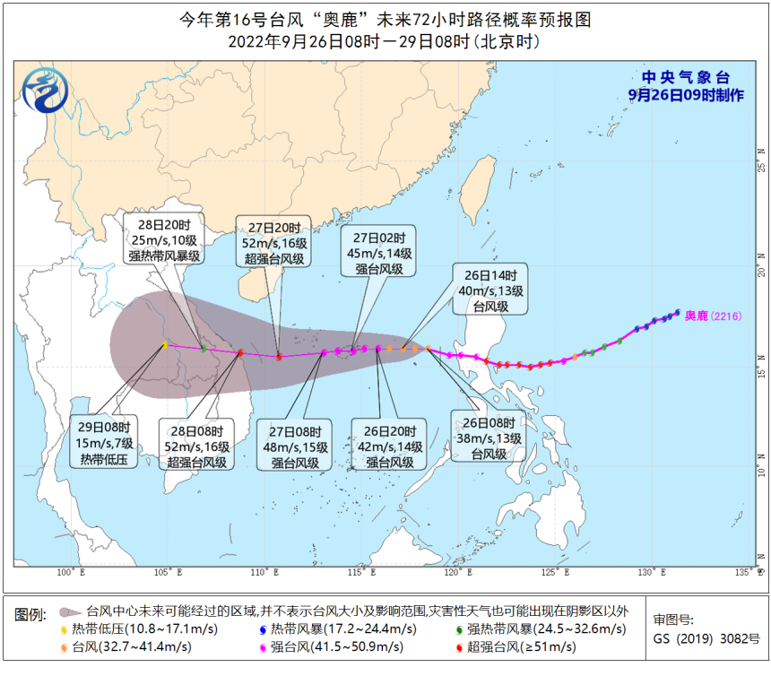
In the next three days, the "Olympic" will seriously affect the South my country Sea and South China coast, bringing wind and rain, especially the sea wind is more vigilant.
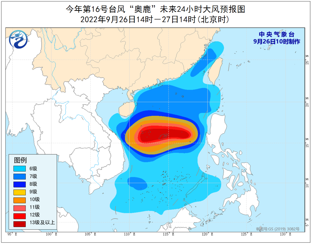
Specifically, today to night, due to the joint influence of "Olympic" and cold air, the coast of Fujian, the coast of Guangdong, the eastern coast of Hainan Island, the western coast of Taiwan, and the Taiwan Strait, the South China Sea, and the Sansha Islands There will be 6 to 7 winds in the nearby waters, with gusts 8 to 9. Among them, the waters of the central part of the South China Sea, the waters near the Xisha Islands and the Neighbor Sansha Islands can reach 8 to 12, and the gusts are 13 to 14. There are 13 to 16 levels, and gusts are 17 or above.
From the 26th to 28th, due to the influence of Typhoon Olympic, there are greater wind and rainy weather in the South China Sea and South China coasts. Some areas of Hainan Island and the Sansha Islands have heavy rain and heavy rainstorms.
Two days after the Ming Dynasty, it will be the main time period of the rainfall of Hainan Island.
In addition, in the next three days, the southwestern region will still be rainy.
②
From September 30th
The new cold air in the north is coming
Southern "Autumn Tiger" look up again
The recent cold air frequently punch card
The autumn of many places in the north is gradually showing
Did you change your autumn?
I want to tell everyone
The new cold air is arranged again

Cold: It is expected that from September 30th to October 3rd, a large -scale precipitation and cooling process will appear from west to east. On heavy rain, rain or snow or snow will appear in part of the northern part of Xinjiang; the temperature generally drops by 4 to 6 ° C, and the land is 8 to 10 ° C. The public needs to pay attention to changes in temperature and add clothes in time.
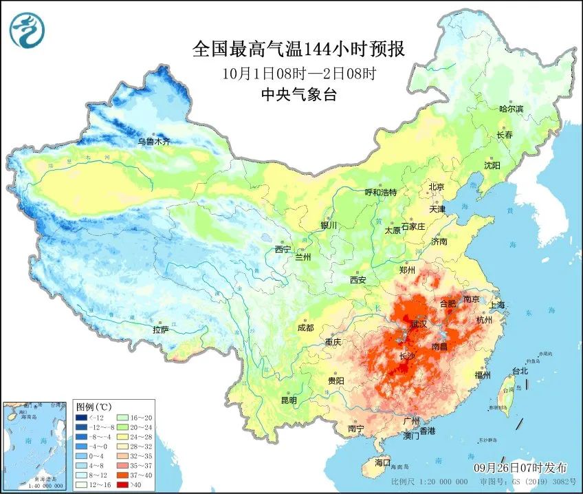
Heat: The south is high -temperature reproduction. It is estimated that from the 30th to October 4th, a large -scale high temperature weather process will occur in the south of Jiangnan and North China. The public needs to pay attention to heatstroke prevention and cooling.
Meteorological expert reminder
Typhoon "Olysu" moves fast, strong strength
When affecting the coast of the South my country Sea and South China
The strongest can reach strong typhoon or super strong typhoon level
Strong wind and wind
In the central part of the South China Sea, the Xisha Islands, and the Zhongsha Islands
Sailing operating vessels and personnel in the nearby waters
Need to evacuate in time
Ship near South China coast returns to Hong Kong to avoid wind in time
Hainan Island has continued to rain since September 20
Especially the eastern part of Hainan Island
Soil water saturation
Affected by the heavy rainfall of typhoon
Mountain floods, geological disasters, and small and medium rivers are high risk of floods
Need to strengthen prevention
Low -lying farmland needs to clear the ditch in advance
To prevent waterlogging disasters
Produced by China Meteorological Administration Xuanke Center (China Meteorological News Agency)
Source: Central Meteorological Observatory
Edit: Zhang Juan
Review: Duan Haoshu

- END -
In the picture, the forest firefighters start the "treasure hunt" journey in Hexi's hinterland!
The map of the picture is a basic training subject of the forest fire team. Throug...
Linwei District Emergency Management Bureau carried out safety management inspection