The rainy rain is cool, pay attention to adding appropriate clothes 丨 Typhoon defense self -rescue guide
Author:Sichuan Provincial Meteorologi Time:2022.09.26

26
Monday
September 2022
In the first autumnal equinox of the lunar calendar in the lunar calendar
National Weather Trends
The rain is overwhelming in the southwestern region.
Yesterday, the southwestern region was still the main position of rainfall in my country. Southeast Gansu, eastern Tibet, southern Sichuan, western Yunnan, and southern Hainan Island appeared to be small to medium rain and heavy rain.
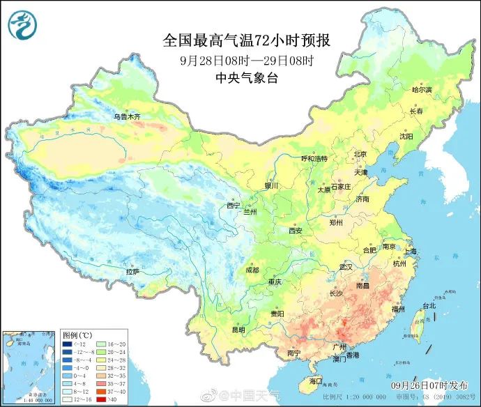
In the next three days, the southwestern region will continue to rain, heavy rain or heavy rain will occur, and rain or snow in high altitude areas will be there. The coastal area of South China, affected by Typhoon 16 and cold air this year, will have strong wind and rain.


The temperature difference between day and night in many places in the north is like two seasons
High temperature increase in Jiangnan South China
Before the National Day holiday, the cold air influenced by my country was weak. Except for the Southwest and the Qinghai -Tibet Plateau, there were not many precipitation in most areas across the country. The temperature would rise in fluctuations, and it returned to normal or high levels. It is expected that the highest temperature in the northeast will rise to about 25 ° C, and the highest temperature from North China to Jianghuai will approach or reach 30 ° C. Under the effect of Qingkong radiation heating, it was even a bit warm in the afternoon, but the lack of clouds and thermal insulation at night, the temperature will drop rapidly. In the next few days, the temperature difference between the day and night in the northern areas can reach about 15 ° C, and the local area will even exceed 20 ° C. In the season, everyone needs to add clothes to keep warm early and beware of colds.
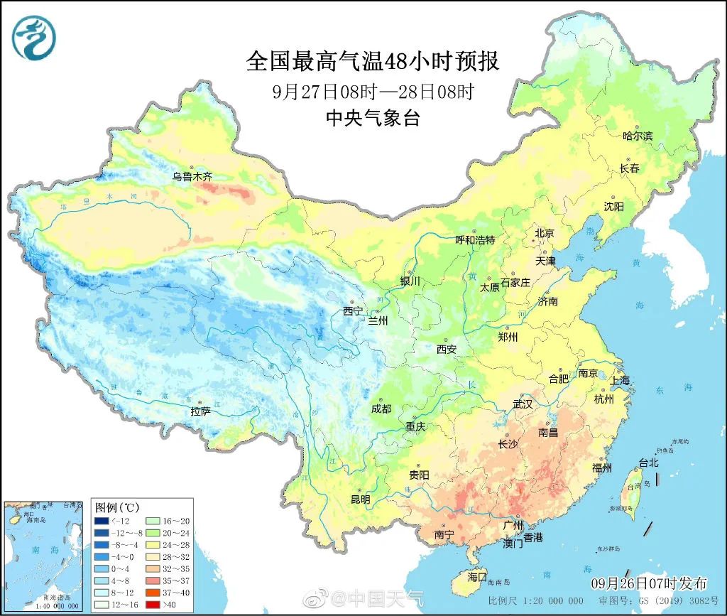
For the southern region, before the National Day holiday, as the subtropical high pressure strengthened the west, the high temperature weather in Jiangnan and South China will gradually increase, and the "autumn tiger" will come again.
Source: China Weather Network
At 14:00, the temperature is active
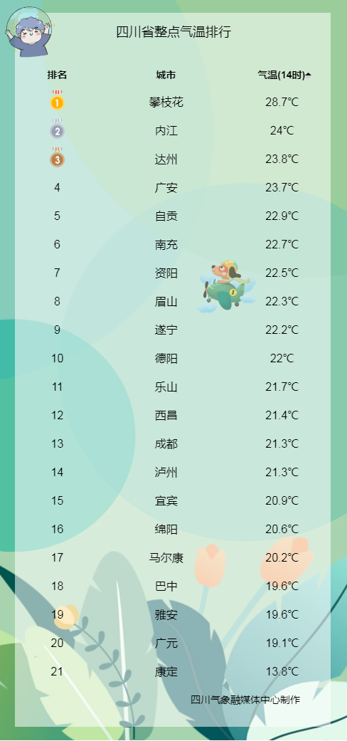
Today, there are scattered showers in most places, accompanied by the temperature of the rainwater, the temperature is not high; there are small rain at night and the temperature is low. Pay attention to adding clothing properly ~
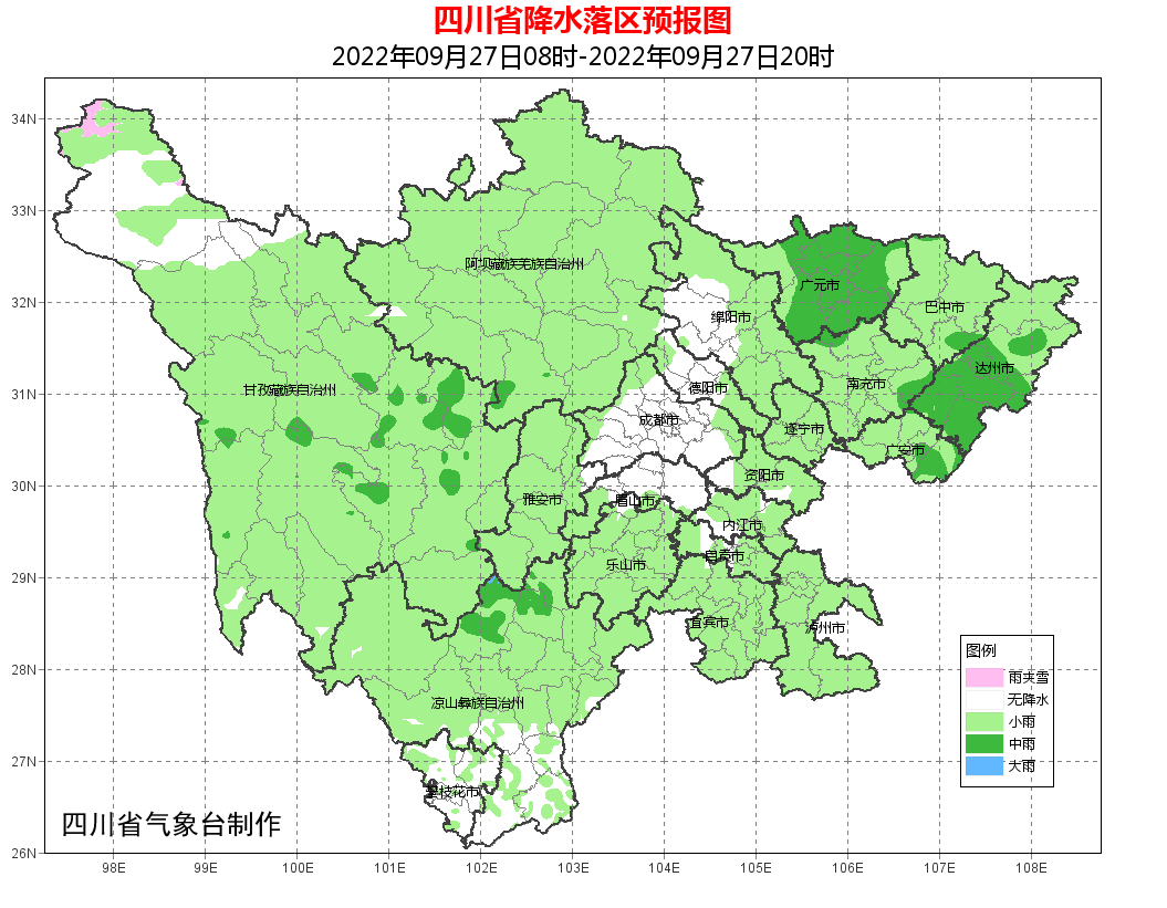
Rainfall
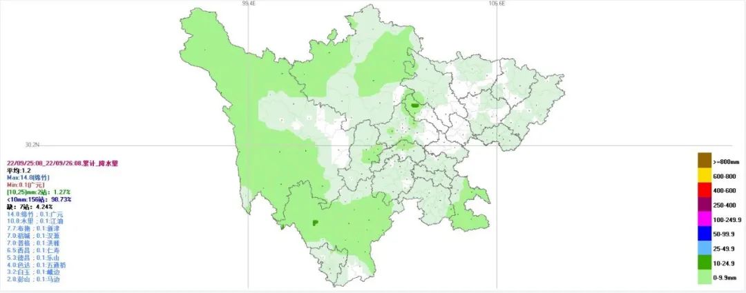
(Cumulative rainfall on the 25th to 08:00 on the 25th)
Yesterday from 08:00 until today at 08, the province's most of the rain, rain in some places, the lowest temperature in the basin was 16 to 18 degrees, and the highest temperature was 22 to 25 degrees.
Future weather trends
In the next three days, most of the provinces are cloudy and cloudy, and there will be more rain or light rain sooner or later. Among them, there will be heavy rain to heavy rain in the local area of the northern part of Western Sichuan Plateau, the west area and the northeast of the basin.

24 -hour weather forecast
Tonight: Most of the basin on the basin is small to medium rain; there will be shower or thunderstorms in the cloudy days in the western Sichuan Plateau and the northern part of Panxi. Or rain.

Tomorrow day: Chengdu, Meishan 2 and Mianyang and Deyang 2 cities in the west of the cities with cloudy clouds with scattered light or scattered rain or showers. The remaining places in the basin are small to the middle of the rain; , There are scattered light rain or showers in the cloudy clouds in the southern Liangshan Prefecture and Cloudy.
Within 24 hours, the lowest temperature in the basin: 17 ~ 19 ° C; the highest temperature: 20 ~ 23 ° C.
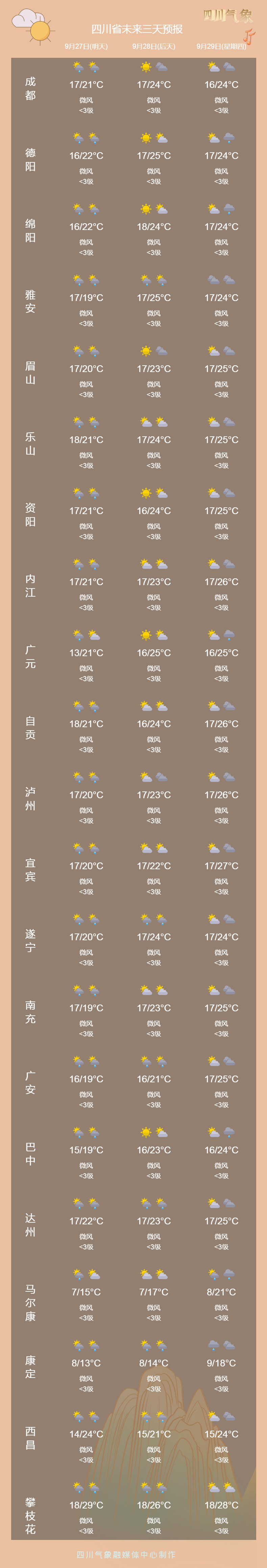
Urban forecast for the next three days
What should I do if the typhoon is here?
One article GET Typhoon Defense Self -Rescue Guide
Typhoon is a low -pressure vortex that occurs on tropical or subtropical oceans. It is a powerful and deep tropical weather system. It is often accompanied by wind, rainstorm and storm trend, causing serious disasters to my country's coastal areas. So, what preparations do residents need to make before the typhoon comes? How to avoid danger when typhoons come?

Before the typhoon comes, residents should listen to, watch or check the typhoon warning information in time, and understand the government's anti -Taiwan action countermeasures; then close the doors and windows, turn off the computer, TV and other electronic equipment; reserve food and water, prepare mobile power, flashlights, and flashlights Wait for emergency items; check whether the circuit, fire fire, gas and other facilities are safe; residents living in various types of dangerous housing, factory buildings, and sheds must be transferred to a safe area in time; if you are already in a strong house, you should be in the window The glass is pasted with a tape into a "rice" figure to prevent the window glass from crushing.

After the typhoon news was released, farmers' friends were prepared early on places that might be attacked by typhoons and floods. For large field crops, the ditch is needed to open the field drainage ditch to ensure smooth discharge irrigation; prepare enough agricultural materials for disaster relief; for the field crops such as rice, corn, soybeans, melon, vegetables, etc. The maintenance and reinforcement is carried out, and the field operators will be evacuated in a timely manner.


- END -
There is a high emotional quotient, called sincere

Author: Insight · Li SiyuanSmart is worse than sincerity, savvy is not as kind.Th...
Red Bloodline — Today in the history of the party history and army | July 23 The first National Congress of the Communist Party of China was held
"Data-version =" 0 "data-vwidth =" 1280 "data-vHeight =" 720 "transcoding =" 1 "style =" width: 400px; " Source 丨 Learning Legion (ID: xuexijuntuan)