Super typhoon landing, rain and rain in the South China Sea!National Day holiday weather ...
Author:South China Sea Release Time:2022.09.26

Autumn equinox has passed
But the South China Sea has not officially "autumn"
Even hanging
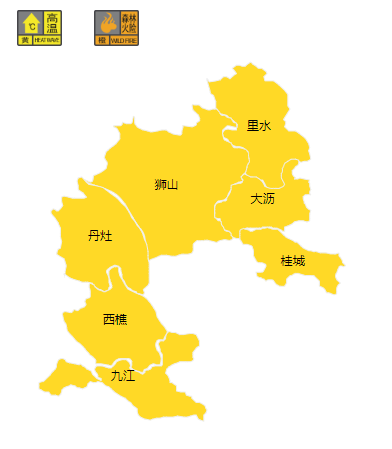
High -temperature yellow warning signal
Forest fire risk orange warning signal
Has the super typhoon "Olysu" landed?
What impact will it affect the South China Sea?
"Olympic" has landed in the Philippines last night
Typhoon No. 16 this year has landed on the Philippines last night (September 25th). It has weakened to a typhoon level. This morning, it was moved by Luzon Island of the Philippines to the central and eastern sea of the South China Sea. The northeast of Huangyan Island is about 95 kilometers.
It is expected that "Olympic" will move west at a speed of 20-25 kilometers per hour, gradually approaching the coast of the eastern part of Vietnam, and the intensity will gradually increase. From the early morning of the 28th to the morning of the coast of central Vietnam.
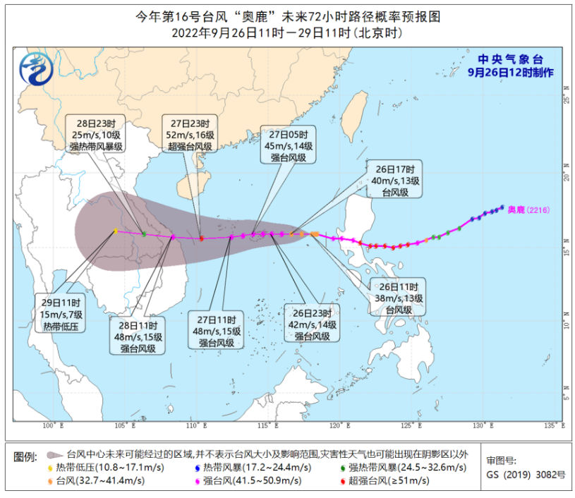
In addition, Typhoon "Rose" (tropical storm level; English name: Kulap) this year was generated on the northwest Pacific Ocean about 1420 kilometers east of Japan's south of Tokyo on September 26. It is expected that "roses" will move northwest at a speed of 20-25 kilometers to move northwest to the northeast, tending to Japan, which will have no impact on the South China Sea.
There will be a wave of thunderstorms in the South China Sea District
@Guangdong's weather is expected that in the next three days, most of the Guangdong Province is controlled by auxiliary high ridges, and the weather is mainly sunny. It will be affected by the "Olympic" peripheral circulation and cold air on the night of the 26th to the 28th. The local rain is strong, there are strong winds along the coast of Guangdong Province, and there are wind and rain on the South China Sea.
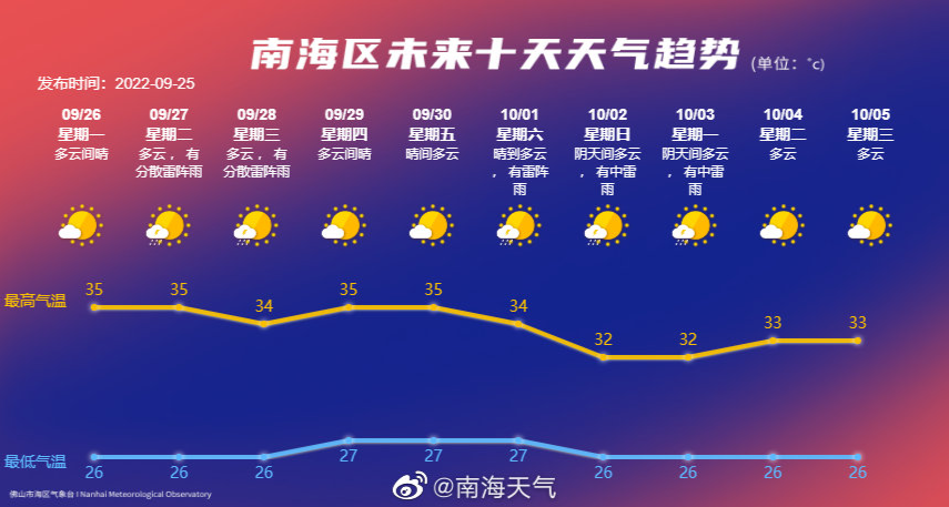
The South China Sea Meteorological Observatory predicts that the local area of Nanhai District is cloudy on September 27, and there will be thunderstorms locally; from 28 to 29, it is affected by the east side of the typhoon "Oolu" to the southeast wind from the north side of the typhoon. There are thunderstorms locally; from October 1st to 3rd, they are affected by the circulation of the typhoon from the periphery of the typhoon, and there are thunderstorms. The specific forecast is as follows:
September 27: Cloudy, local thunderstorms, 27 ~ 35 degrees, northeast wind 2 ~ 3;
September 28: Cloudy, decentralized thunder shower, 27 ~ 35 degrees, east wind 3 level;
September 29: Cloudy, decentralized thunder shower, 26 ~ 35 degrees, east wind 2 ~ 3;
September 30: Cloudy, local thunderstorms, 27 ~ 35 degrees, east wind 2;
October 1: Cloudy, thunder showers, 27 ~ 33 degrees, east wind 2 ~ 3 levels;
October 2: Cloudy in cloudy, there are thunderstorms, 26 ~ 32 degrees, east wind 2 ~ 3 levels;
October 3: Cloudy, thunder showers, 26 ~ 32 degrees, east wind 2 ~ 3 levels;
October 4: Cloudy to sunny, 27 ~ 33 degrees, east wind 2 levels;
October 5: Cloudy, 27 ~ 34 degrees, east wind 2 levels;
October 6: Cloudy, 26 ~ 32 degrees, northern wind 2 ~ 3.
One week
The weather jumps repeatedly between the rain and rain
In short, everyone remember to bring an umbrella just right
There is still a week before the National Day holiday
The latest weather dynamics
Please pay attention to the meteorological department forecast

Follow the video number of the South China Sea, master the latest information of the South China Sea
- END -
Beijing built 211 community health service centers
As of 2021, the city's community health service center (station) has reached 2111, and basically achieved 15-30 minutes of walking with community health services, opening long-pressed services, promot...
Fuzhou continues to grasp various flood prevention work

To pay tribute to the rain in the rainFuzhou continues to grasp various flood prev...