"Olysu" will continue to issue typhoons and heavy rain in Hainan from the morning of the 28th to noon from the morning of the 28th to noon.
Author:Hainan Agricultural Reclamatio Time:2022.09.27
September 27, 2022
The weather forecast released by Hainan Meteorological Observatory today (dangerous weather)
Typhoon three -level warning
Typhoon No. 16 this year, "Olympic" (super typhoon), is at 16:00 at 15.6 degrees north latitude and 110.8 degrees east longitude. The wind power is 16 (55 meters/second), the seventh-level wind ring radius is 200-280 kilometers, the tenth-level wind ring radius is 100 kilometers, and the 12-level wind ring radius is 30 kilometers. It is expected that the "Olympic" will continue to move west at a speed of about 25 kilometers per hour, and the intensity will be strengthened. It will land on the coast of the eastern part of Vietnam from the morning of the 28th to noon. After landing, the strength will weaken rapidly.
Three -level warning
Affected by the "Olympic Deer", it is expected that in the next 24 hours, most towns and villages in Haikou, Ding'an, Wenchang, Tunchang, Qionghai, Qionghai, Wanning, Lingshui, Polying, and Sanya For precipitation above 50 mm, some towns, Qiongzhong, Wanning and Baoting will have more than 100 mm precipitation. Relevant units and personnel are requested to prevent work.
Geological disaster weather risk level 4 warning
It is expected that in the next 24 hours, the southwestern part of Qionghai City (Shibi Town, Longjiang Town, Huishan Town), northwest of Wanning City (Longjan Town, Beida Town, Sanxian Luo Town, Nanqiao Town), northern Lingshui County (Qunying Township, Ti Meng Township, Township Town), northern (Shiling Town) in Baoting County, the central and eastern parts of Wuzhishan (Nansheng Town, Shuiman Township), southern Baisha County (Nankai Township, Yuanmen Township), Qiongzhongzhong The rainfall of the county has a certain risk of geological disasters (blue warning). Please ask the relevant departments of the city, county, towns and towns to do a good job of geological disaster defense.
Blue mountain flood disaster meteorological risk early warning
It is expected that in the next 24 hours, Sanya City, Puzhou, Qionghai City, Wanning City, Wuzhishan City, Lingshuili Autonomous County, Qiongzhongli Miao Autonomous County, Ding'an County, Baisha Li Autonomous County, Tunchang County, Paoting Li Miao Autonomous County The possibility of the weather risk of flood disasters in some towns and towns in cities and counties reaches the level of blue warning. Other regions may also cause rhododendron disasters due to the short -term duration of the local area. Relevant departments are requested to pay attention to the prevention and early warning and transfer of risk aversion.
In terms of ocean, affected by the "Olympic" and the rapid flow of partial flow:
The Qiongzhou Strait, from 17:00 on the 27th to 8:00 on the 28th, to the east to the northeast wind level 7, the gust of gust is 9-10; 8:00 on the 28th to 20:00 on the 28th, the east to the northeast wind 6-7, the gust of 8-9 level ; 20:00 on the 28th to 08:00 on the 30th, the east wind is 5-6, and the gust is 7-8.
At the surface of the Beibu Gulf, the East and Changjiang of the island to the sea surface of the high area of the Lingao, the night from the 27th to the night of the 28th, the northeast wind is 6-7, and the gust is 8-9; -8.
The island's Chengmai to the sea surface of Haikou, on the night of the 27th, the east to the northeast wind level 7, the gust of gust is 9-10; the 28th day, the east to the northeast wind 6-7, the gust of 8-9; the night from the 28th to the 29th At night, the east wind is 5-6, and the gust of gust is 7-8.
The island Wenchang and Qionghai to the sea surface of Ledong. On the night of the 27th to the 28th day, the east wind is 9-10, the gust is 11-12; the night of the 28th, the east wind is 6-7, the gust is 8th; the 29th daytime; the 29th daytime; At night, the east wind is 6, and the gust of gust is 7-8.
On the sea near the Xisha Islands, at night on the 27th, the southeast wind is 10-11, and the gusts are 12th; the 28th day to night, the southeast wind is 8-9, the gust is 10-11; Level 6, gust 7-8.
On the sea near the Zhongsha Islands, on the night of the 27th, the southeast wind is 8-9, and the gusts are 10-11; on the 28th to the night, the southeast wind is 7-8, and the gust is 10th; the 29th day to the night, the southwind 5 -6 levels, gusts 7-8.
The sea near the Nansha Islands, from the night of the 27th to the night of the 28th, the southwest wind is 6-7, and the gust is 8th; the 29th to the night, the southwest wind level 5-6, and the gust of 7.
In addition, the Typhoon No. 3 of Typhoon No. 3 in the ports of the coastal areas of the island and Qionghai to Ledong area does not change. Typhoon No. 2 of Typhoon 2 of the ports in the coastal areas of the east and Changjiang to Haikou area of the island will not change.
Land weather forecast
Night from the night to the 28th day of the day:
There are heavy rain in the north, with a minimum temperature of 23-25 degrees, and the highest temperature is 28-30 degrees
In the middle, there are heavy rain on the clouds, the lowest temperature is 22-24 degrees, and the highest temperature is 27-29 degrees
In the east, there are heavy rain on the clouds, heavy rain in the area, the lowest temperature is 23-25 degrees, and the highest temperature is 28-30 degrees
In the west, there is a middle to heavy rain on the clouds, heavy rain in the local area, the lowest temperature is 22-24 degrees, and the highest temperature is 28-30 degrees
In the south, there are heavy rains on the cloudy days, heavy rainstorms, the lowest temperature is 23-25 degrees, and the highest temperature is 28-30 degrees
Xisha Yongxing Island, with thunder shower in cloudy on the cloudy days, 10 levels in the southeast wind, temperature: 26-31 degrees
Zhongsha Huangyan Island, cloudy on the cloudy days, there are thunder showers, southwind, 8 levels, temperature: 26-29 degrees
Nansha Yongxia Reef, cloudy and cloudy in cloudy, cloudy in the southwest, temperature: 27-30 degrees
28th to the 29th day of the day:
In the north, there is a cloudy to heavy rain in the cloudy days, heavy rain in the local area, the lowest temperature is 25-27 degrees, and the highest temperature is 29-31 degrees
In the middle, there is a cloudy to heavy rain in the cloudy days, heavy rain in the local area, the lowest temperature of 23-25 degrees, the highest temperature of 30-32 degrees in the east, cloudy clouds are cloudy to heavy rain, local heavy rain, minimum temperature 24-26 degrees, the lowest temperature is 24-26 degrees. The highest temperature is 29-31 degrees
In the west, there is a small cloudy in cloudy to the middle rain, the lowest temperature is 23-25 degrees, and the highest temperature is 30-32 degrees
In the south, there is a cloudy to heavy rain in cloudy days, heavy rain in the local area, the lowest temperature is 23-25 degrees, and the highest temperature is 30-32 degrees
Xisha Yongxing Island, with thunder shower in cloudy, the southeast wind is 9th, the temperature: 26-32 degrees
Zhongsha Huangyan Island, cloudy and cloudy on the cloudy days, there are heavy rain and thunder, southwind, temperature: 26-30 degrees
Nansha Yongxia Reef, there are thunder shower in cloudy days, 6 southwest winds, temperature: 27-30 degrees
From the night of the 29th to the 30th day:
In the north, there is a cloudy to heavy rain, the minimum temperature is 24-26 degrees, and the highest temperature is 29-31 degrees
In the middle, cloudy is heavy to heavy rain, with a minimum temperature of 23-25 degrees, and the highest temperature 30-32 degrees
In the east, there is a cloud to heavy rain, the lowest temperature is 24-26 degrees, and the highest temperature is 30-32 degrees
In the west, there are thunderstorms in the clouds, the lowest temperature is 23-25 degrees, and the highest temperature is 30-32 degrees
In the south, there are thunderstorms in the clouds, with a minimum temperature of 24-26 degrees, and the highest temperature 30-32 degrees
Xisha Yongxing Island, cloudy with thunder showers, southwind 6, temperature: 26-32 degrees
Zhongsha Huangyan Island, cloudy and cloudy on the cloudy days, heavy rain turns heavy rain, southwind 6, temperature: 26-29 degrees
Nansha Yongxia Reef, there are thunder shower in cloudy on the cloudy days. The southwest wind turns to the southwest wind 6, the temperature: 27-30 degrees
In addition, from the 27th to 28th, the land on the east and southern coastal of the island will be accompanied by a Grade 9-11 wind, and the land in the north and the coast of the north and the west will be accompanied by a level 6-8.
Weather trends in the next 4-7
On the night of the 30th, there were showers or thunderstorms across the island, and the local area was so heavy. Around October 1, a new tropical low pressure may be generated in the South China Sea. From October 1st to 3rd, our province will have a heavy precipitation process. The wind power of each sea area is 5-7, and the weather turns well on October 4.
Notice! Recently, there are risks of flood disasters in some towns and towns in these cities and counties in Hainan

Typhoon No. 16 this year was coming. At 12 o'clock on September 27, the Hainan Provincial Department of Water Affairs and the Provincial Meteorological Bureau jointly issued a warning of the blue mountain flood disaster meteorological risk warning.
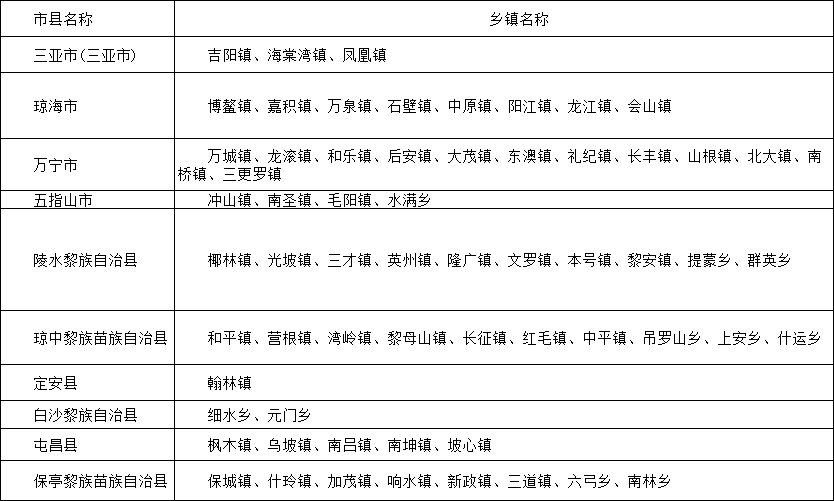
Statistical list of townships and towns in Shanhong Disaster Meteorological Risks in Hainan Province.
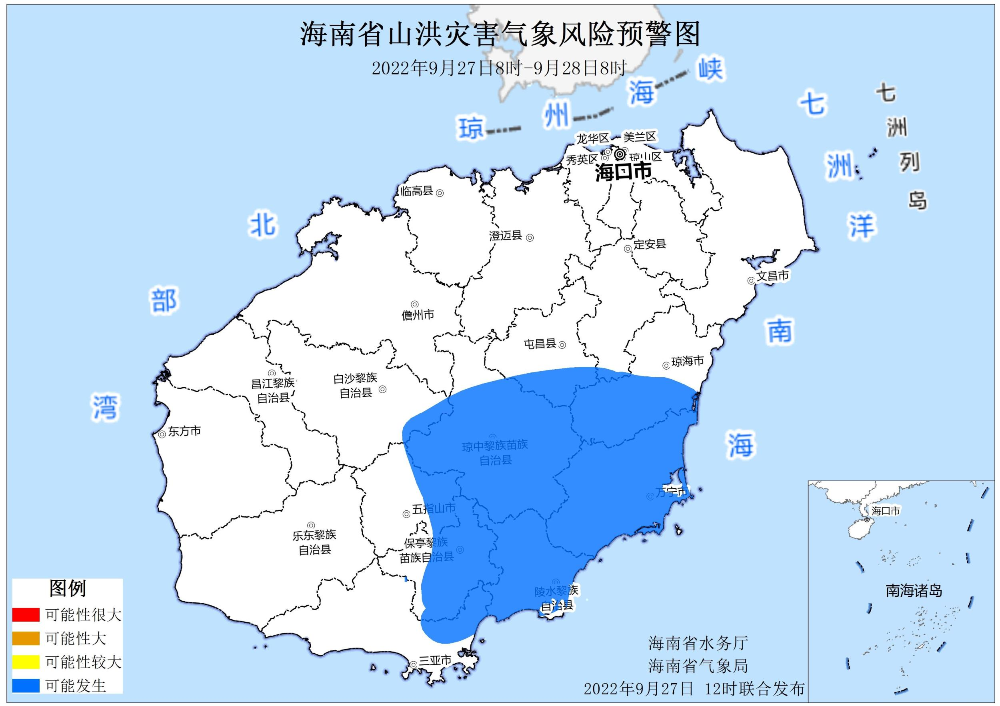
It is expected that from 8:00 on September 27 to 8:00 on September 28th, Sanya City, Qionghai City, Wanning City, Wuzhishan City, Lingshui Li Autonomous County, Qiongzhongli Miao Autonomous County, Ding'an County, Baishali Autonomous County, Tunchang, Tunchang The possibility of the weather risk of flood disasters in some towns and towns in counties and counties in counties and counties and counties in the county, Paoting Li, and Miao Autonomous County reached the level of blue warning.
Other regions may also cause rhododendron disasters due to the short -term duration of the local area. Relevant departments are requested to pay attention to the prevention and early warning and transfer of risk aversion.
Blue warning area
Typhoon "Olysu" strikes Hainan to launch a flood prevention and wind prevention level III emergency response
Typhoon No. 16 this year was coming. At 11:00 on September 27th, the General Headquarters of Hainan Province Flood Control, Wind and Drought Prevention, launched a level III emergency response. implement.
According to the meteorological forecast, Typhoon "Olympic Deer" No. 16 this year has been strengthened from a strong typhoon level at 2 am on the 27th to super typhoon level. At 7 o'clock, the center is 15.6 degrees north latitude and 112.4 degrees east longitude. On the central and eastern part of the South China Sea in the south of Yongxing Island, the largest wind power near the center is 16 (55 meters/s) near the center. Affected by Typhoon "Olympic Deer", it is expected that in the next 24 hours, the island Haikou, Chengmai, Ding'an, Wenchang, Tunchang, Qionghai, Qionghai, Wanning, Lingshui, Baoting, Wuzhishan, and Sanya 12 cities and counties. Some townships will have more than 50 mm precipitation, of which more than 100 mm precipitation will occur in some towns in Qiongzhong and Wanning.
Hainan continues to release the South China Sea Wave II -level alarm: multiple sea surfaces will have 2.5 ~ 10 meters waves
At 10:00 on September 27th, Hainan Provincial Ocean Forecasting Station continued to release the South China Sea Wave II alarm (orange). It was affected by the typhoon "Olympic Deer". It is expected that there will be 2.5 ~ 10 meters of large waves from the sea at noon today to noon tomorrow to noon. Madness.
Among them, south of Hainan Island and near the sea near Xisha have 8.0 to 10.0 meters of mad waves. There are 6.0 to 7.0 meters of crazy waves on the sea surface of Nansha. The southern part of the Beibu Gulf and the east of Hainan Island has a huge wave of 4.0 to 5.0 meters on the east. Near Dongsha, east of Leizhou Peninsula, northern part of the north, near Zhongsha, Northeast Nansha, and the sea surface of the Qiongzhou Strait are 2.5 to 3.5 meters.
There will be 2.5 to 4.0 meters from east of Hainan Island to the south of the southern part of the coast. There will be a large wave of 2.5 to 3.5 meters in the near -shore waters in the northeast.
Please do a good job of preventing waves in advance.
Disclaimer: Reprinted or quoted this public account news, please indicate the source and the original author.

Source | New Hainan Client
Edit | Liang Ning
Editor in charge | Wu Qirong
Duty header | Zhong Ye
- END -
Ai Airlines 丨 A Great Wall Millennium History!Qi Great Wall: Deeply witnessed the years

The millennium stands, witnessing the changes in the years.On the top of the hustl...
Yangjiang Disabled Persons' Federation organizes the professional skills improvement training course for the disabled
Yangjiang Day News (Reporter/Zhang Beizhi Intern/Zeng Zihui) On September 20, Love Warm Yang · Building Dreams forward Yangjiang City 2022 The opening ceremony of the professional skills improvemen