Pay attention to the typhoon "Olysu": The impact of the super typhoon level on Guangxi has been strengthened again on the sea surface of the central part of the South China Sea
Author:China Well -off Time:2022.09.28
The Central Meteorological Observatory continued to issue a typhoon yellow warning at 06:00 on September 27:
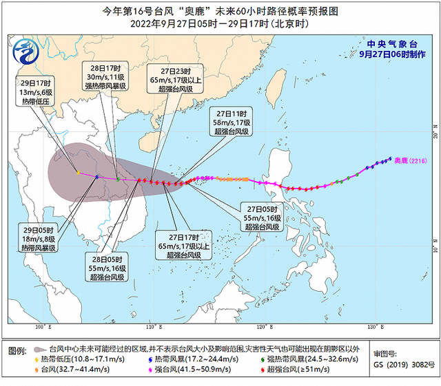
Typhoon No. 16 this year has been strengthened to a super typhoon level on the sea of the central part of the South China Sea at 2 am today (27th). At 6 o'clock in the morning, it is located in Sansha City, Hainan Province (Xisha Yongxing Island) (Xisha Yongxing Island). On the sea of about 145 kilometers east of the south, it is 15.6 degrees north latitude and 112.7 degrees east longitude. The maximum wind near the center is 16 (55 meters/s), the lowest air pressure in the center is 930 hundred Pache, and the seven-level wind ring radius is 200-280 200-280 Komem, 10 kilometers in the ten -level wind ring, 50 kilometers radius of the 12th -level wind ring.
It is expected that the "Olympic Deer" will move west at a speed of about 20 kilometers per hour, and the intensity will also be enhanced. After crossing the waters of the south of the Xisha Islands, it will land on the central part of Vietnam on the morning of the 28th (50-55 Mi/second, 15-16 levels, strong typhoon or super typhoon), the intensity gradually weakened after landing.
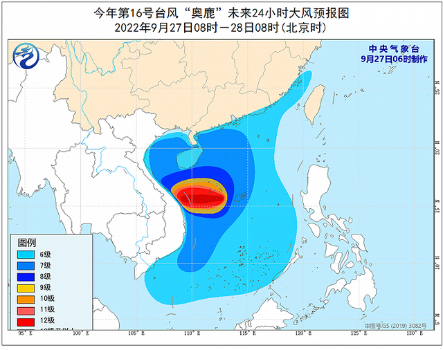
Dafeng forecast: 08:00 on the 27th to 08:00 on the 28th, the western part of the Taiwan Strait, the South China Sea, the Xisha Islands, the Zhongsha Islands and the Nansha Islands waters, the Qiongzhou Strait and the central and southern part of Fujian, the coast of Guangdong, and the coast of Hainan Island will be 6- Grade 8 winds, gusts 9-10, of which the west of the central part of the South China Sea and the waters near the Xisha Islands can reach level 9-12, and the gust of gust is 13-14. -17 levels, gusts above 17 or higher.
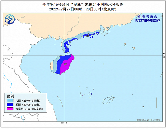
Precipitation forecast: 08:00 on the 27th to 08:00 on the 28th, the coast of the southwest of Guangdong, most Hainan Island, the Xisha Islands, and the Zhongsha Islands will have heavy rain. There are heavy rainstorms (250-300 mm) near the waters near the Xisha Islands.
"Olysu" jumps three levels of super typhoons! The impact on Guangxi appears ...
On September 26th, Typhoon "Olympic" No. 16 this year was moved from Luzon Island, Philippines to the central and eastern part of the South China Sea. It is expected that it will move westward and gradually approach the coast of eastern Vietnam. Its intensity has strengthened very quickly. From the night of the 24th to the day of the 25th, the typhoon "Olysu" jumped three levels in a row, which was quickly strengthened from a strong tropical storm to a super typhoon. So, will it bring the "typhoon rain" to Guangxi, or is it a "air -conditioning machine" that is hot?
Because the path of Typhoon "Olympic" is adjusted south, it can basically exclude its possibility of landing in Hainan. However, its intensity is strong and fast, and the coast of the South China Sea and South China must still be alert to the adverse effects of wind and rain. For Guangxi, the typhoon "Olysu" cannot send a large range of timely rain to the current lack of water, and it can only throw a little rainwater in the local area. The Guangxi Meteorological Observatory predicts that due to the influence of the peripheral circulation of Typhoon "Oolu", strong wind and rainy weather will occur in the south of Guangxi, the sea surface and coastal areas, especially from the 27th to 29th.
The meteorological department reminds all parts of Guangxi coast to do relevant defense work in advance. Maritime ships and maritime operators in the affected areas should return to Hong Kong to avoid wind in time. Binhai, island tourism and water projects need to pay attention to safety.
In terms of temperature, due to the south of the Typhoon "Olympic", the sinking airflow it brought this time has little effect, and the "air -conditioning machine" hot air effect is not obvious. However, don't forget that there are another veteran who created hot+high temperature -the subtropical high pressure is still entangled in Guangxi.
Two days of this Ming Dynasty, as the subtropical high pressure strengthened the west extension, the entire Guangxi District sang the rhythm of Xiao "Qing". 37 ° C, 29-33 ° C in other areas. After the typhoon rain is launched, the high temperature range will shrink to northern Gui from 28-29.
Defense guide:
1. Government and relevant departments do a good job of preventing typhoon rescue emergency in accordance with their duties.
2. Related water operations and past ships should return to the port to avoid wind, strengthen port facilities, and prevent the ship's anchor, stranding and collision.
3. Stop outdoor dangerous operations such as large -scale rally indoor and outdoor and high altitude.
(Tuyuan Network China Xiaokang.com Comprehensive CCTV, Guangxi News Network)
- END -
The total investment scale is nearly 15 billion!Zaozhuang fully speeds up the construction of the new pharmaceutical industry project

Qilu.com · Lightning News, July 5th, on July 5th, the Jaozhuang Municipal Governm...
The United States, Japan and Australia Foreign Minister jointly stated that the dangerous "suffix" 丨 Beijing observation

On August 5, US Secretary of State Brills, Australian Foreign Minister and Japan F...